31. March 2015 · Comments Off on Mid day Update – March 31 · Categories: snow, spring, weather discussion, weather forecast · Tags: ,

RADAR

Wet snow is now being reported in the Pocono’s. No rain showers have made it to the ground yet in western New Jersey but should in the next hour or two. Look for showers or periods of light rain for the remainder of the afternoon. There could be a few heavier showers mixed in. This should only be 1-2/10″

For location above 1000′ look for wet snow that could leave a slushy accumulation.

Any precipitation that continues into the late afternoon or early evening could mix with wet snow even in the lower valleys.

Temperatures are currently in the mid 40’s in western New Jersey and holding steady

31. March 2015 · Comments Off on Last Day of March Weather · Categories: snow, spring, weather discussion, weather forecast · Tags: , , ,

10930190_953330374686297_7192930958843981954_n

Early morning risers in western New Jersey are seeing a very nice morning with partly sunny skies and temperatures in the mid to upper 30’s. Unfortunately this will not continue as clouds will arrive quickly and bring light rain by mid day or early afternoon. For elevations above 1000′ this will be wet snow.


11080933_1039056939457228_2453635313482645280_n

By late afternoon or early evening, and light rain falling could start mixing with snow even at the lower elevations. I expect little if any accumulations mostly on colder surfaces. The exception will be elevated areas above 750′ – they might see a coating to 1″ in spots.


11102961_1039056852790570_174768434388363984_n


Wednesday will be sunny but on the cooler side with highs in the 40’s. Thursday and Friday will be mild days with highs in the 60’s. But showers will be on the increase starting Thursday evening continuing into Friday.

30. March 2015 · Comments Off on End of March Weather Outlook · Categories: snow, spring, weather discussion, weather forecast · Tags: , , ,

7Day

Early risers in western New Jersey saw some light snow this morning that coated the ground in a few areas. This was the result of a cold front that moved through. Winds have increased and will stay breezy today but high temperatures will make it to the low 50’s but feel cooler in the wind.

On Tuesday a small fast moving clipper type system will approach the area and give us some rain or wet snow shower in the afternoon ending by early evening. Then we start off April on a sunny but chilly note on Wednesday. Warmer air arrives for the end of the week but so does the chance of showers by Thursday night and Friday.

28. March 2015 · Comments Off on Chilly Saturday With Flurries? · Categories: snow, spring, weather discussion, weather forecast · Tags: , , ,

RADAR

The calendar may say Spring and late March but today will feel more like early February. It could be worse: some folks in SE PA and Long Island are waking up to some light snow this morning that is coating the ground in some places! There’s a chance some sections of western New Jersey could see some flurries today. If you are in a heavier snow shower don’t be surprised if it briefly whitens the ground.

7Day

Believe it or not our normal high temperature now should be 54 degrees! Today will be blustery and cold with high’s not getting out of the upper 30’s. This is unfortunate as I know there are some outdoor activities (i.e. Easter Egg Hunt) that begin now. After a very cold start, Sunday will be a little warmer and feature mostly sunny skies and less wind that should help a little. Then there’s a chance of some light rain or snow showers Sunday night into Monday morning as warmer more seasonable air makes it into the region. End of week looks to have high temperatures near 60 but with increased rain chances.

26. March 2015 · Comments Off on Warm Air Finally Arrives · Categories: spring, weather discussion, weather forecast · Tags: , ,
Radar 17:35 pm showing heavy rain near Harrisburg, PA heading East

Radar 17:35 pm showing heavy rain near Harrisburg, PA heading East

It took most of the day but the warm front finally made it past our area. As of right now western New Jersey temperatures is in the upper 50’s to around 60.

A band of heavy rain with some thunder and lightning is heading east. As seen above, it’s currently near Harrisburg. Be on the lookout this evening for an initial heavier period of rain and possible a rumble of thunder then periods of rain the remainderĀ of the night.

7Day

The cold front will bring us back to what we’re used to which is below normal temperatures. We might even see some flurried Friday night into Saturday. Saturday may stay in the 30’s for high temperature. Keep in mind we should now be in the low 50’s for high temperatures… But it looks like we will have some 50’s for highs next week.

25. March 2015 · Comments Off on Thursday Warm-up Followed By More Cold · Categories: spring, weather discussion, weather forecast · Tags: , , ,

7 Day Forecast

Western New Jersey is experiencing some light rain showers this Wednesday afternoon. The goods news is these showers are the forerunner of some much milder air. This will really be demonstrated on Thursday with high temperatures in the low 60’s! But with warm air comes rain. Today we should only see light amounts and tomorrow about 1/2.”

Unfortunately the warm air will not last too long. A strong cold front will come through late Thursday into Friday morning and cool us down below normal once again. In fact Saturday looks quite chilly and raw with high temperatures in the upper 30’s with a breeze and scattered showers or flurries can’t be rules out.

22. March 2015 · Comments Off on Sunday Weather Discussion · Categories: spring, weather discussion, weather forecast

Capture

Today in western New Jersey will be a nice sunny day, for February. But by late March standards it will be cold and breezy. Temperatures will probably not climb much out of the 30’s and there will be a breeze. Tonight we dip into the teens and rinse and repeat tomorrow. Tuesday shows a little improvement then warmer on Wednesday and Thursday but with a chance of showers.

21. March 2015 · Comments Off on First Full Day of Spring Weather · Categories: spring, weather discussion, weather forecast · Tags: , , ,

20150321_085842

Yesterday’s storm certainly over-performed as far as I’m concerned. While I knew more snow would fall that would accumulate, I didn’t expect the longevity of the intensity that resulted in more snow accumulating than I forecasted. Stewartsville received 4″ of wet snow. Here are some additional accumulations in the western New Jersey area:

...HUNTERDON COUNTY...
   FRANKLIN               5.2   730 PM  3/20  COCORAHS
   STANTON                5.0   742 PM  3/20  SOCIAL MEDIA
   WHITEHOUSE STATION     4.8   602 PM  3/20  TRAINED SPOTTER
   READINGTON             4.5   839 PM  3/20  TRAINED SPOTTER
   KINGWOOD               4.5   634 PM  3/20  SOCIAL MEDIA
   THREE BRIDGES          4.3   638 PM  3/20  TRAINED SPOTTER
   READINGTON TWP         1.4   100 PM  3/20  TRAINED SPOTTER

...WARREN COUNTY...
   OXFORD                 4.3  1244 AM  3/21  TRAINED SPOTTER
   STEWARTSVILLE          4.0   950 PM  3/20  SOCIAL MEDIA
   ALLAMUCHY              3.6   737 AM  3/21  TRAINED SPOTTER
   HACKETTSTOWN           3.5   630 PM  3/20  TRAINED SPOTTER
   RIEGELSVILLE           3.0   733 AM  3/21  CO-OP OBSERVER
   BLAIRSTOWN             2.0   152 PM  3/20  SOCIAL MEDIA

…NORTHAMPTON COUNTY… WILLIAMS TWP 6.5 1209 AM 3/21 TRAINED SPOTTER FORKS TWP 6.0 728 PM 3/20 TRAINED SPOTTER BETHLEHEM 5.5 559 PM 3/20 TRAINED SPOTTER EASTON 5.3 615 PM 3/20 SOCIAL MEDIA HELLERTOWN 5.2 1032 PM 3/20 TRAINED SPOTTER DANIELSVILLE 4.5 1031 PM 3/20 SOCIAL MEDIA BUSHKILL TWP 4.5 1232 AM 3/21 TRAINED SPOTTER NAZARETH 4.3 953 PM 3/20 TRAINED SPOTTER BUSHKILL CENTER 4.0 630 PM 3/20 TRAINED SPOTTER MARTINS CREEK 3.8 515 PM 3/20 TRAINED SPOTTER

Capture
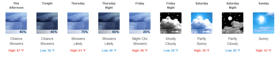
Saturday will be the better of the two this weekend weather wise. Look for partly sunny skies with temperatures near 50. There will be a breeze which combined with the temperature and sun should help to melt most if not all that fell yesterday. There could be a brief rain shower this evening as colder air arrives in the region. Sunday will be sunny but cold for this time of year. Colder than normal will continue into the new week until a nice warm-up arrives on Wednesday, albeit with a chance of rain.

20. March 2015 · Comments Off on Mid Day Storm Update · Categories: snow, spring, weather discussion, weather forecast · Tags: ,

Capture

Wet snow continues across western New Jersey on Friday afternoon, the first day of Spring. The back edge of the snow is now visible on radar near Harrisburg and moving in this direction. Furthermore in the last 15 minutes I’m starting to notice some gaps in the radar to our west so the steady snow should become more intermittent as the afternoon wears on.


Snow starts to stick to roads in western New Jersey on first day of Spring 2015

Snow starts to stick to roads in western New Jersey on first day of Spring 2015

As of noon, Stewartsville received 1.2″ of snow. At this point I suspect we will receive around the top end of my 1-3″ forecast.

20. March 2015 · Comments Off on First Day of Spring With Snow · Categories: snow, spring, weather discussion, weather forecast · Tags: , , ,

Capture

Temperatures this morning are already above freezing slightly and we have an E-SE wind. When the snow arrives (very light snow just entered western New Jersey as of 9 am) the lower atmosphere will cool down slightly. But the March sun will penetrate the clouds and help to warm up paved surfaces.

As you can see in the above radar, precipitation initially will be very light and intermittent.

northeast

I wider view of radar show opening in the coverage in Southern PA but more moisture to the west.

10478135_947853811900620_950837872726962015_n

We are still under a winter weather advisory until 8 pm tonight. The NWS is still forecasting 4-6″ for our area. My forecast still stands at 1-3.” More snow will fall but not accumulate. More will accumulate at higher elevations (generally above 750 ft). Also if it continues to snow moderately beyond 4-5 pm that snow may start sticking on untreated surfaces as well. But the storm should start winding down in our area from 6-9 pm.

If you feel like it, go out to your local Rita’s for a free water ice today!! lol

If will feel more spring like tomorrow with partly sunny skies and high temperatures in the upper 40’s and low 50’s.

Plugin for Social Media by Acurax Wordpress Design Studio
Visit Us On TwitterVisit Us On FacebookVisit Us On PinterestVisit Us On YoutubeVisit Us On Instagram