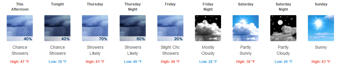
16. May 2018 · Comments Off on Wet Weather Replaces Wild Tuesday · Categories: spring · Tags: , , ,

5 Day NWS forecast

After a wild Tuesday weather-wise, we are much calmer, cooler and wetter today. Many locations yesterday reported strong wind gusts (46 in Stewartsville), heavy rain (0.42″ in Stewartsville), hail (1/4″ report in Stewartsville) and more. There was even a tornado warning to our west in eastern PA. There were also other tornado warnings in the region. One was just confirmed in Putnam county.

Today’s showers will continue on and off. Tomorrow we should get a little bit of a break but there is a threat of more rain on Friday. There is some disagreement on how far north the rain will come on Friday. If it gets into western New Jersey, we will easily see an additional 1-2″ of rain. If it stays to our south, less.

12. November 2015 · Comments Off on Get Ready For the Wind! · Categories: Fall, snow, weather discussion · Tags: , , , ,

Radar20151112-0920

Western New Jersey has already seen some light rain this morning. Look for more periods of light rain to continue today. As seen in the above radar, some is about to move in from the SW. Look for amounts to be about 1/4″ in general.


12196006_1168674916495429_692845836948372440_n

This rain is associated with a fast moving cold front. This is tied to the same storm that brought snow to the Rockies. No we’re not going to get snow here – sort of. But it will get real windy on Friday as a result of the front pushing through and the intense storm passing by accompanied by high pressure moving in. Winds could easily gust to 40 mph. Please secure any holiday decorations. As always watch wet leaves on the roadways.

Up in the Poconos and far north west New Jersey on Saturday, there’s a chance of seeing some wet snow showers. Temperatures on Saturday will feel colder than they are due to the wind. Temperatures should stay most of the day in the 40’s and perhaps peeking at 50 for a daytime high. Winds should gradually diminish later on Saturday.

10. November 2015 · Comments Off on On and Off Rain for Tuesday · Categories: Fall, weather discussion · Tags: , ,

Radar20151110

Look for periods of rain on Tuesday. Right now we are in between two areas of rain. Steadier rain is to our east and moving away from us. An upper level disturbance is bringing slightly steadier rain to our west and that is heading in our direction. Look for that to arrive later this afternoon into the evening. Right now it looks like 1/4″ to 1/2″ of rain in general – some spots a little more.


09. November 2015 · Comments Off on Rain on the way for Tuesday · Categories: Fall · Tags: , ,


namprecip1

A storm system developing to our south and west will move into western New Jersey Tuesday morning and provide needed rain on and off for much for the day. Most areas should pick up 1/4″ – 1/2″ or rain. Some areas that receive heavier downpours will receive more – perhaps as much as 1.” Winds will pick up out of the East and North East and be gusty at time. It will feel like a November day I’m sure.

Veteran’s Day should feature dry weather with partly cloudy skies for western New Jersey and seasonable temperatures. An approaching front will bring a chance of rain shower back into the area on Thursday. Right now the weekends looks good with seasonable weather.

09. October 2015 · Comments Off on Showers On the Way: Update · Categories: Fall · Tags: , , ,


Radar20151009-1525

As of 3:30, rain and some thundershowers is moving in from the NW. Keep an eye to the sky for the next few hours.

Radar20151009-1048

A cold front will be approaching the area later today. Some pre-frontal showers have already popped up and should be entering western New Jersey within the next hour.

After that we should have a little break then more activity later this afternoon. Don’t be surprised if you even hear a rumble of thunder! Yes it’s October but it does happen occasionally. Look for the afternoon showers to start as early as 2 pm but hopefully should be clear of the area in time for Friday night HS football!

11. August 2015 · Comments Off on Showers and Thundershower About To Move In · Categories: Summer, thunderstorms · Tags:

20150811-1345

As mentioned this morning, additional showers and thundershowers are about to move into western New Jersey. There are some rumbles of thunder but noting severe at the moment. Look for it to last 30-60 minutes and pick up an additional 0.25-0.50″ of rain

11. August 2015 · Comments Off on Rainy, Humid Tuesday · Categories: Summer · Tags: , , ,

20150811-0824

Stewartsville NJ received 0.67″ of new rainfall as of 7 am this morning. As you can see in the radar above, we still have a few more heavier showers that will pass through western New Jersey this morning.

Then the next question is how much, if any additional rain will we receive this afternoon? It all depends on how much sunshine and how warm it gets. The early morning rain was cue largely to a warm front. If you haven’t stepped outside yet our friend humidity is back for a big visit. But a cold front will pass though later today and will probably result in some additonal showers.

08. June 2015 · Comments Off on Tornado Watch Issued for parts of area · Categories: thunderstorms · Tags: ,

Update#4: Tornado watch issued further east for eastern PA and parts of western New Jersey:

ww0278_radar

Update #3: Threat continues in PA. Now two tornado warnings issued:

Radar1545-06082015 mcd0942

Update #2: Tornado watch no up for eastern PA:

ww0276_radar_big

Update: A discussion from the SPC talks about tornado possibilities in PA and a Tornado watch to our north.

ww0274_radar_big mcd0939

The Storm Prediction Center has placed the area just to the west of western New Jersey in a slight risk for severe thunderstorms later today and tonight. Looks for showers and thunderstorms to move through the area from 4-8 pm. We could receive 1 – 1.5″ of new rain.


10257687_1079863318709923_393135304527718393_n


11392939_1079863322043256_5552423558209637511_n


26. March 2015 · Comments Off on Warm Air Finally Arrives · Categories: spring, weather discussion, weather forecast · Tags: , ,
Radar 17:35 pm showing heavy rain near Harrisburg, PA heading East

Radar 17:35 pm showing heavy rain near Harrisburg, PA heading East

It took most of the day but the warm front finally made it past our area. As of right now western New Jersey temperatures is in the upper 50’s to around 60.

A band of heavy rain with some thunder and lightning is heading east. As seen above, it’s currently near Harrisburg. Be on the lookout this evening for an initial heavier period of rain and possible a rumble of thunder then periods of rain the remainderĀ of the night.

7Day

The cold front will bring us back to what we’re used to which is below normal temperatures. We might even see some flurried Friday night into Saturday. Saturday may stay in the 30’s for high temperature. Keep in mind we should now be in the low 50’s for high temperatures… But it looks like we will have some 50’s for highs next week.

25. March 2015 · Comments Off on Thursday Warm-up Followed By More Cold · Categories: spring, weather discussion, weather forecast · Tags: , , ,

7 Day Forecast

Western New Jersey is experiencing some light rain showers this Wednesday afternoon. The goods news is these showers are the forerunner of some much milder air. This will really be demonstrated on Thursday with high temperatures in the low 60’s! But with warm air comes rain. Today we should only see light amounts and tomorrow about 1/2.”

Unfortunately the warm air will not last too long. A strong cold front will come through late Thursday into Friday morning and cool us down below normal once again. In fact Saturday looks quite chilly and raw with high temperatures in the upper 30’s with a breeze and scattered showers or flurries can’t be rules out.

Social Network Widget by Acurax Small Business Website Designers
Visit Us On TwitterVisit Us On FacebookVisit Us On PinterestVisit Us On YoutubeVisit Us On Instagram