03. August 2020 · Comments Off on What To Expect With Isaias And When · Categories: Hurricane, Summer · Tags: , , ,

Very rare for our area Tropical Storm Warning is in effect for our entire area.

We also have a Flash Flood Watch for our entire region. I expect several flood warnings from the 3-5″ of expected rain on Tuesday

With Isaias track a little bit further west, there will be a chance for some severe weather in eastern sections. There’s even a chance for some weak tornadoes which is common on the right hand side of a tornado when near land.

As of 2 pm Monday, Isaias is south of SC and moving N at 13 mph. This will put the storm in our area starting Tuesday afternoon.

The main threat from this storm for our area is the heavy rain and potential flooding. 3-5″ of rain is forecast for our area. Some location could have locally 6+ inches of rain.

With so much rain in a short period of time leads to the potential of flooding. WE are in a moderate risk of excessive rainfall that can lead to flash flooding.

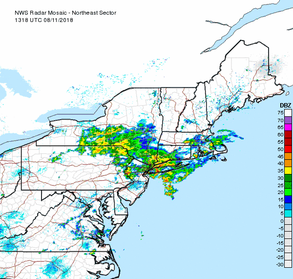
A look at the radar in the eastern US shows Isaias south of SC and moving north. You will also notice the rain in bands between where Isaias is right now and further north. This is a key point in our forecast for tonight and tomorrow.

Let’s talk wind. The above graphic shows winds gust tomorrow a 4 pm in knots. To convert to mph will be slightly higher than these numbers. This clearly shows there will be gusty winds tomorrow afternoon

I also wanted to show a graphic of wind direction for the same time tomorrow at 4pm. Notice that for many locations in western NJ our winds will be out of the N-NE. Further East they will have E or SE winds. Along the NJ coast they will have strong Southerly winds

Timeline

Tonight – look for rain showers to start mid to late evening in some areas. There is a chance for some scattered thunderstorms although this will be primarily south and east of us.

Overnight – periods of rain will gradually become heavier and steadier. Winds will also start to pick up as well.

Tuesday morning. – Periods of rain will continue to become heavier and steadier. From mid to late morning on the rain should be mostly heavy in nature. Winds will become quite gust. Avoid travel from mid morning on if possible.

Tuesday afternoon – this will be the height of the storm with bad conditions. Heavy rain and gusty winds will lead to some areas of flooding

Tuesday evening – the storm looks to start pulling away in early evening in southern locations. When the rain starts to taper off, the winds will remain gusty but slowly start to subide.

Tuesday night. The storm will continue to pull away out of our area. There could be a few rain showers early in the evening. Winds will slowly diminish.

25. July 2020 · Comments Off on Weekend Weather Briefing · Categories: Summer, weather discussion · Tags: ,

The early morning fog has lifted but the humidity remains. Look for warmer temperatures today with high temperatures near 90.

As is the case when we have warm temperatures and plenty of humidity, there is a chance of spotty afternoon showers and thundershowers. The severe risk should be minimal.

The Saturday morning satellite shows a mix of clouds and sun. Let’s root for the clouds if you dislike hot temperatures as they will help keep down the temperature a little bit

In looking at Sunday and beyond, we turn up the heat and humidity through Monday. Tuesday and Tuesday evening will be our next chance of widespread showers and thundershowers with our next cold front. That will hopefully cross out area on/before Wednesday and pave the way for more comfortable humidity and near seasonable high temperatures for the rest of the week. Fingers crossed!

16. July 2020 · Comments Off on Excessive Heat Watch Posted · Categories: Heatwave, Summer

An Excessive Heat Watch has been issued for much of the area for Sunday afternoon through Tuesday. The combination of heat and humidity may result in heat indices of 100 to 110 degrees. Stay weather aware. #pawx #njwx #dewx #mdwx

Next week, dangerous excessive heat is expected for much of the region. Heat index values above 100F are possible for at least a portion of the region from Sun through Wed, with the worst of the heat wave likely coming on Mon. #njwx #mdwx #dewx #pawx

07. July 2020 · Comments Off on Summertime Weather Pattern Continues · Categories: Summer · Tags: ,
01. July 2019 · Comments Off on Beautiful Weather Today; Triple H’s Return Tomorrow · Categories: Summer, weather discussion

Another pleasant air mass arrived yesterday and is giving us a break in the heat and especially the humidity, Overnight low temperatures this morning were in the comfortable upper 50’s.

Don’t get too used to it – it is July afterall! The humidity will return tomorrow along with temperatures in the upper 80’s. There will also be a near daily chance of summertime typical shower and thundershowers.

22. June 2019 · Comments Off on Near Perfect Summer Weekend Weather · Categories: Summer, weather discussion

Warmer weather and humidity will return next week after a great weekend weather wise. Look for typical scattered afternoon and evening thunderstorms in some spots. These should not be widespread and more scattered in nature. Tuesday looks more favorable than Monday.

Enjoy the first full weekend of Summer 2019!

11. August 2018 · Comments Off on Another Soggy Weekend · Categories: flood watch, Summer · Tags: , , , ,

Flash Flood Watch

Most sections of western New Jersey saw and heard a good amount of rain and thunderstorms in the wee hours of this morning. Stewartsville received 1.04″ of new rain as of 7:30 am today. More rain has fallen since then. All of this rain has resulted in a Flash Flood Watch for the entire area.

NE Radar Loop

As of mid-day the good news is most of the heavier rain has moved thru extreme western New Jersey and will be out of all of northern NJ soon. As you can see in the radar loop above there appears to be a break in the precipitation. How long will it last? I suspect we will see rain returning by mid to late afternoon.

Weather Outlook this weekend

Our overall forecast from 8 am this morning until Sunday morning is more heavy rains possible with flash flooding possible.

1-2 Day Precip Total forecast

The above map shows extreme western New Jersey forecast to receive about another 1.50″ of rain from Saturday morning until Monday morning. Sections further to the east could be closer to 2″

08. August 2018 · Comments Off on Slight Risk of Severe Weather Later Today · Categories: Summer, thunderstorms · Tags: , ,

SPC shows marginal risk of severe weather today

The Storm Prediction Center has our entire area in a marginal risk for severe weather later today and tonight. A weak cold front will be approaching and moving through the area later today and tonight. This will produce some scattered thunderstorms later today and tonight. At this time they don’t look to be very strong or in a squall line. Instead they look scattered. But keep in mind any thunderstorm can turn strong and deadly quickly. The old adage “when thunder roars, head indoors” is good advice.

We did have another heat wave as of yesterday. Tuesday was our third day in a row of high temperatures hitting 90 or better. Today will be close but we may stay just shy of the 90 degree mark. Even if the temperature doesn’t hit 90 the humidity will certainly make it feel that warm if not warmer.

5 Day NWS forecast

After today we should only see high temperatures in the 80’s for at least the next 5 days. Looking longer range temperatures should increase again somewhat later next week perhaps.

06. August 2018 · Comments Off on Heat Advisory Today · Categories: Heat, Summer · Tags:

Heat Advisory Issued Today

339 AM EDT Mon Aug 6 2018

...HEAT ADVISORY REMAINS IN EFFECT FROM NOON TODAY TO 7 PM EDT
THIS EVENING...

* HEAT INDEX VALUES...Between 100 and 104 due to temperatures in
  the low to mid 90s, and dewpoints in the lower 70s.

* TIMING...The highest heat index values will occur during the
  afternoon into the early evening.

* IMPACTS...The heat and humidity may cause heat stress during
  outdoor exertion or extended exposure.

PRECAUTIONARY/PREPAREDNESS ACTIONS...

A Heat Advisory means that a period of hot temperatures is
expected. The combination of hot temperatures and high humidity
will combine to create a situation in which heat illnesses are
possible. Drink plenty of fluids...stay in an air-conditioned
room...stay out of the sun...and check up on relatives and
neighbors.

Take extra precautions...if you work or spend time outside. When
possible...reschedule strenuous activities to early morning or
evening. Know the signs and symptoms of heat exhaustion and heat
stroke. Wear light weight and loose fitting clothing when
possible and drink plenty of water.

To reduce risk during outdoor work...the occupational safety and
health administration recommends scheduling frequent rest breaks
in shaded or air conditioned environments. Anyone overcome by
heat should be moved to a cool and shaded location. Heat stroke
is an emergency...call 9 1 1.
24. July 2018 · Comments Off on Rain Continues · Categories: precipitation, Summer, weather discussion · Tags:

Stewartsville rain this month

Stewartsville received 1.47″ of new rain as of 7 am this morning. Nearly 1″ of that was received yesterday morning from after 7 am until 8:30 am!

As you can see in the above chart, we’ve been getting a lot of rain recently. This is in contrast to how dry it was just 10 days ago and beyond. Be careful what you ask for!

Today, Tuesday we should see a little less in overall rain but don’t put the galoshes away just yet. Wednesday the systems looks to shift back to the east and give us more rain. Then hopefully Thursday it will relax again and then hopefully the entire system will nudge to the east on Friday via a front that may give us a half way descent weekend. But be forewarned: none of these days will be completely rain-free…

Animated Social Media Icons by Acurax Responsive Web Designing Company
Visit Us On TwitterVisit Us On FacebookVisit Us On PinterestVisit Us On YoutubeVisit Us On Instagram