20. March 2017 · Comments Off on Spring Has Arrived, But For How Long? · Categories: spring · Tags:

Western New Jersey enjoyed a very nice Sunday with light winds, sunshine and nice temperatures! As the Spring Equinox arrived at 6:30 this morning look for more of the same weather today and tomorrow.

Winter will make a brief comeback this Wednesday and Thursday with January like cold. Wednesday will only have high temperatures in the upper 30’s with breezy conditions. Wednesday night will shiver us with teens for lows with still below normal reading on Thursday. Our normal high this time of year is 50-51.

Warmer weather will arrive on Friday along with some showers.

At this point I think I can safely say we are out of the threat of any further accumulating snow. Sure we will still have some cold outbreaks now and then and still can’t rule out some frozen precipitation. To get any accumulating from this point forward you almost need perfect conditions and I don’t see that happening anymore this cold season.

17. March 2017 · Comments Off on Snow to Rain to Snow for Weekend · Categories: snow, spring · Tags:
NWS snow forecast for Saturday into Sunday morning

NWS snow forecast for Saturday into Sunday morning

After a beautiful sunny Friday afternoon clouds will increase later on as a warm front approaches western New Jersey. The warm front may give us some snow showers this evening.

Then a weak area of low pressure will form along the front early Saturday morning and move into our area. This will give us some light snow early Saturday morning. In southern sections of western New Jersey this should change to light rain showers as warmer air moves in Saturday mid day and early afternoon. Then colder air will filter back into western New Jersey and change any rain over to light snow. This light snow should continue off and on into Sunday morning.

How much are we talking about from both events? 1-3″ with lower amounts to the south and closer to 3″ (or perhaps a little more) in northern and elevated areas.

Yes technically Spring does arrive Monday morning but it certainly won’t feel or look like it. After colder weather on Sunday, there will be a brief warm up on Monday and Tuesday. But that will be followed by another very cold outbreak for Wednesday.

15. March 2017 · Comments Off on Winter Weather Advisory for Wednesday · Categories: snow · Tags:

It’s blue skies, why the weather advisory? A couple of reasons: 1) there can be some snow showers today that can leave anywhere from a coating to an inch or two and b) the strong winds of today that will cause blowing and drifting of the snow resulting in reduced visibility.

...WINTER WEATHER ADVISORY NOW IN EFFECT UNTIL 8 PM EDT THIS EVENING...

* LOCATIONS...Most of eastern Pennsylvania and northwestern New   Jersey.

* HAZARDS...Snow and blowing snow.

* ACCUMULATIONS...Up to 2 inches of new snow accumulation.

* IMPACTS...Blowing and drifting snow will lead to reduced   visibility especially in open areas. In addition, isolated snow 
  squalls today could lead to additional quick snow accumulations,   reduced visibility and exacerbating already hazardous driving conditions.

* WINDS...Northwest 15 to 25 mph with gusts up to 40 mph.

* TIMING...Blowing snow is possible through the day. Snow squalls will be possible from mid morning through early this evening.

PRECAUTIONARY/PREPAREDNESS ACTIONS...

A Winter Weather Advisory for snow and blowing snow means that visibilities will be limited due to a combination of falling and
blowing snow. Use caution when traveling, especially in open areas.
15. March 2017 · Comments Off on Blizzard Snow Totals · Categories: snow · Tags:

In the western New Jersey area, the following amounts of snow fell: Map of the entire area below.

...HUNTERDON COUNTY...
   FLEMINGTON             8.9   230 PM  3/14  TRAINED SPOTTER
   READINGTON TWP         8.7   145 PM  3/14  TRAINED SPOTTER
   WHITEHOUSE STATION     6.8   106 PM  3/14  TRAINED SPOTTER
   EAST AMWELL TWP        6.0   417 PM  3/14  TRAINED SPOTTER
   TEWKSBURY TWP          6.0   921 AM  3/14  TRAINED SPOTTER
   READINGTON             5.3   815 AM  3/14  TRAINED SPOTTER

...MORRIS COUNTY...
   LAKE HOPATCONG        15.0   345 PM  3/14  TRAINED SPOTTER
   GREEN POND            13.5   115 PM  3/14  TRAINED SPOTTER
   JEFFERSON TWP         13.0   755 PM  3/14  TRAINED SPOTTER
   BUTLER                13.0   542 PM  3/14  TRAINED SPOTTER
   KINNELON              12.8   115 PM  3/14  TRAINED SPOTTER
   2 SE BEATTYESTOWN     12.0   430 PM  3/14  TRAINED SPOTTER
   MARCELLA              11.5   211 PM  3/14  TRAINED SPOTTER
   ROCKAWAY              11.0   118 PM  3/14  SOCIAL MEDIA
   RANDOLPH TWP          11.0   200 PM  3/14  TRAINED SPOTTER
   PINE BROOK            10.0  1220 PM  3/14  SOCIAL MEDIA
   2 SSE MORRISTOWN      10.0   345 PM  3/14  SNOW AND SLEET
   DENVILLE              10.0  1129 AM  3/14  SOCIAL MEDIA
   MORRIS TWP            10.0   648 PM  3/14  TRAINED SPOTTER
   CHATHAM                9.0  1118 AM  3/14  TRAINED SPOTTER
   LAKE PARSIPPANY        8.9  1135 AM  3/14  TRAINED SPOTTER
   WHIPPANY               8.5  1105 AM  3/14  TRAINED SPOTTER
   MADISON                8.5  1214 PM  3/14  TRAINED SPOTTER

...SUSSEX COUNTY...
   VERNON                20.3   519 PM  3/14  TRAINED SPOTTER
   WANTAGE               19.8   438 PM  3/14  2.02 LIQUID
   HIGHLAND LAKES        19.5   526 PM  3/14  TRAINED SPOTTER
   5 NW WANTAGE          19.0   204 PM  3/14  TRAINED SPOTTER
   SUSSEX                17.5  1050 AM  3/14  SOCIAL MEDIA
   LAFAYETTE             17.0   357 PM  3/14  TRAINED SPOTTER
   MONTAGUE              16.5  1059 AM  3/14  TRAINED SPOTTER
   STOCKHOLM             15.0   545 PM  3/14  TRAINED SPOTTER
   NEWTON                15.0   445 PM  3/14  TRAINED SPOTTER
   2 NE NEWTON           12.0   230 PM  3/14  TRAINED SPOTTER

...WARREN COUNTY...
   HACKETTSTOWN          20.0   645 PM  3/14  PUBLIC
   BLAIRSTOWN            15.8   430 PM  3/14  TRAINED SPOTTER
   ALLAMUCHY             13.0   502 PM  3/14  SNOW MIXED WITH SLEET
   WASHINGTON             9.0   948 AM  3/14  TRAINED SPOTTER
   RIEGELSVILLE           5.0   812 AM  3/14  TRAINED SPOTTER
   STEWARTSVILLE          5.0   700 AM  3/14  SOCIAL MEDIA
PA
...NORTHAMPTON COUNTY...
   2 SSE TATAMY          15.1   330 PM  3/14  TRAINED SPOTTER
   BETHLEHEM             13.9   430 PM  3/14  TRAINED SPOTTER
   NAZARETH              12.5   945 AM  3/14  PUBLIC
   BUSHKILL TWP          11.2  1054 AM  3/14  TRAINED SPOTTER
   EASTON                10.5   121 PM  3/14  SOCIAL MEDIA
   MARTINS CREEK         10.3   117 PM  3/14  TRAINED SPOTTER
   1 NNW NORTHAMPTON HE  10.0   943 AM  3/14  PUBLIC
   HELLERTOWN             9.9   200 PM  3/14  TRAINED SPOTTER
   4 S ACKERMANVILLE      6.2   811 AM  3/14  1/4SM VIS

Blizzard of 2017 snow totals in the north east

Blizzard of 2017 snow totals in the north east

14. March 2017 · Comments Off on Tuesday Morning Blizzard Update · Categories: snow · Tags: ,
Heavy snow in Stewartsville, NJ

Heavy snow in Stewartsville, NJ

The Blizzard warning continues for all of western New Jersey. The powerful storm has formed and is impacting the area. Stewartsville has received 7.8″ of snow as of 10 am this morning. There has been more snow to our north and west.

The storm has formed further west than originally thought. This has allowed the upper atmosphere to be warmer than originally thought. This has resulted in sleet from time to time. Those areas that received a lot of sleet will see lower snow totals. All areas will change back to snow as the storm pulls away.

There has been several reports of thundersnow/sleet in NYC! This gives you an example of how powerful this storm is.

The areas in the blue hatch are where the heaviest snow will form from this storm going forward. Note this is further north and west as southern and eastern areas are getting sleet.

Winds will continue to be a factor.

The snow totals forecast has been adjusted due to all the sleet. Southern and eastern areas of western New Jersey will receive 8-12″ while further north will receive 12-24″ – higher totals in areas that do NOT change/mix with sleet

13. March 2017 · Comments Off on Blizzard Warning Means Strong Winds And Possible Power Outages · Categories: snow · Tags:

You should keep your cell phones charged and make sure your rechargeable batteries are all set to go, just in case. Also make sure you have some candles, preferably the ones with glass on the sides so it’s safe if it tips over.

The above map is predicted wind gusts by a computer model for tomorrow. As you can see we may see some good wind gusts in western New Jersey tomorrow!

13. March 2017 · Comments Off on Tuesday storm upgraded to Blizzard Warning · Categories: snow · Tags:

The National Weather Service has upgraded the Winter Storm Warning for western New Jersey to a Blizzard warning. As impressive as that sounds (and it is) the only real difference between the two is the amount of sustained wind you receive. Technically a blizzard has 3 consecutive hours of steady 35 mph winds, reduced visibility due to falling AND blowing snow.

Most of the computer model this morning has suggested the storm will be more intense. This has lead to the NWS to increase their prediction to 18-24.” At this point I’m going to do the same. We can and do get that much snow from strong storms in western New Jersey so this may be added to the list.


...Blizzard Warning in effect from 8 PM this evening to 6 PM EDT Tuesday...

The National Weather Service in Mount Holly has issued a Blizzard Warning, which is in effect from 8 PM this evening to 6 PM EDT
Tuesday. The Winter Storm Warning is no longer in effect.

* Locations...eastern Pennsylvania and much of northern New   Jersey.

* Hazard types...heavy snow and strong winds.

* Accumulations...snow accumulation of 18 to 24 inches. 

* Timing...snow begins between 10 PM and midnight from southwest   to northeast across the warning area, becoming heavy at times 
  with snowfall rates of three to four inches per hour for   several hours Tuesday morning. Snow will diminish late in the 
  day Tuesday.

* Impacts...the heavy snow will make many roads impassable and   may produce widespread power outages due to the weight of the 
  snow on tree limbs and power lines. Strong winds will lead to   blowing snow, reduced visibility, and additional power 
  outages. 

* Winds...northeast 15 to 25 mph with gusts up to 40 mph.

* Visibilities...less than one-quarter mile for several hours. 

* Temperatures...in the mid 20s.

Precautionary/preparedness actions...

A Blizzard Warning means severe winter weather conditions are expected or occurring. Falling and blowing snow with strong winds
and poor visibilities are likely. This will lead to whiteout conditions...making travel extremely dangerous. Do not travel. If
you must travel...have a winter survival kit with you. If you get stranded...stay with your vehicle.
12. March 2017 · Comments Off on Winter Storm Warnings Issued for Tuesday Storm · Categories: snow · Tags:

Based on everything I’ve seen so far today, I’m maintaining my 10-18″ forecast for snow from the Tuesday storm. There may even be some sections that see MORE than that amount in western New Jersey!

The NWS forecast is for 8-18″ which is in line with my thinking.

12. March 2017 · Comments Off on Sunday Look At Tuesday Storm · Categories: snow · Tags: ,

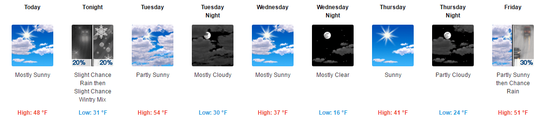
Unseasonably cold weather continues this weekend in western New Jersey. This will continue for most if not all of the week ahead.

Computer model forecasting continues to show a substantial snow storm for western New Jersey for very late Monday evening into most of Tuesday. The map above is a forecast from one of the many computer models meteorologists use as tools to forecast weather.

Tuesday storm will be composed of two factors, one storm that is now in the Pacific NW and the second a tropical low disturbance down in the gulf states. These two are predicted to interact with each other off the mid Atlantic coast up into the north east.

Of course everyone wants to know how much snow. In such a dynamic storm like this one will be almost always banding of precipitation sets up. If you are in a band for a considerable amount of time precipitation can be falling at extremely heavy rates. Meanwhile where there is no banding and only lighter precipitation is falling, it’s a much different story. You can see some examples of that in the map above. Looks at the dark blues in western New Jersey compared to the light blue in parts of eastern PA.

So in a storm that has bands of precipitation, depending on where the storm moves, also determines where the bands of precipitation set up.

Based on everything I’m seeing now I’m predicting that western New Jersey will receive 10-18″ from Tuesday’s storm. I dislike putting out such a wide range in amounts but at this time its the best call. The NWS map above agrees with this thinking and says 12-14″ is “likely” for western New Jersey.

Timing: snow doesn’t look to start in our area, at this time, until around midnight Monday night. It should be somewhat light at the beginning. But then will get heavier and steadier overnight and last into a good portion of Tuesday.

Our NWS has places western New Jersey under a Winter Storm Watch for this event. Further to the east in NE New Jersey, NYC and Long Island a Blizzard watch is in effect. So that tells us this storm will have gusty winds, especially on Tuesday.

can things change before the storm? Absolutely. If and when they do I’ll post updates here or on the Facebook page.

10. March 2017 · Comments Off on Initial Thoughts On Snow Next Week · Categories: snow · Tags: ,

By now word is spreading on social media that we are having a big snowstorm next Tuesday. And it could very well happen. I just wanted to post something today with initial thoughts on the storm. Yes it can happen. Computer models have been showing this storm now for the last several days which is a good sign of consistency. Of course that doesn’t mean it will happen. It’s still 3-4 days out. The image above is an official forecast issued by the NWS.

One computer model forecast of Tuesday outcome

One computer model forecast of Tuesday outcome

I believe there will be a storm LATE on Monday night into most of Tuesday. The details just need to be worked out. Those details won’t be known until we have a better understanding of the exact track of the storm. If it follows the track and intensity shown on several computer models today, it will be a significant storm.

As is the case with these storms there are several possibilities: 1) go further out to sea 2) go further inland and give us more mix and rain 3) be weaker than forecast and so on and so on.

So at this point, keep the potential in your plans for next week that we might have a disruptive storm on Tuesday. I’ll post more on the storm over the weekend as time permits.

Plugin for Social Media by Acurax Wordpress Design Studio
Visit Us On TwitterVisit Us On FacebookVisit Us On PinterestVisit Us On YoutubeVisit Us On Instagram