11. August 2018 · Comments Off on Another Soggy Weekend · Categories: flood watch, Summer · Tags: , , , ,

Flash Flood Watch

Most sections of western New Jersey saw and heard a good amount of rain and thunderstorms in the wee hours of this morning. Stewartsville received 1.04″ of new rain as of 7:30 am today. More rain has fallen since then. All of this rain has resulted in a Flash Flood Watch for the entire area.
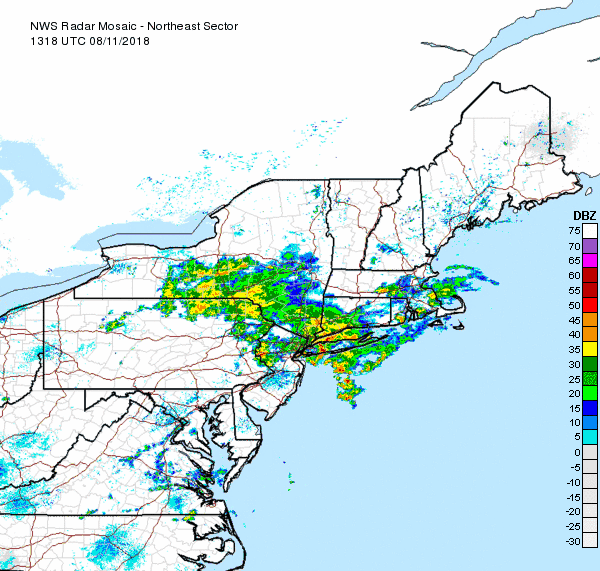
NE Radar Loop

As of mid-day the good news is most of the heavier rain has moved thru extreme western New Jersey and will be out of all of northern NJ soon. As you can see in the radar loop above there appears to be a break in the precipitation. How long will it last? I suspect we will see rain returning by mid to late afternoon.

Weather Outlook this weekend

Our overall forecast from 8 am this morning until Sunday morning is more heavy rains possible with flash flooding possible.

1-2 Day Precip Total forecast

The above map shows extreme western New Jersey forecast to receive about another 1.50″ of rain from Saturday morning until Monday morning. Sections further to the east could be closer to 2″

01. August 2018 · Comments Off on Threat for Severe Weather Later Today · Categories: thunderstorms · Tags: , ,

Threat for severe weather later today

There continues to be a slight risk of severe weather later today. It will not be an all day rain but rather spotty here and there. If the weather looks threatening, head indoors!

01. September 2015 · Comments Off on Stewartsville August 2015 Summary · Categories: Monthly Summary · Tags: , ,
Stewartsville Monthly Weather Observation Summary
Aug-15
DAY MAX MIN MEAN PRECIP COMMENTS
1 87.0 63.0 75.0 0.00
2 86.0 59.0 72.5 0.00
3 88.0 62.0 75.0 T Light rain shower in evening
4 86.0 65.0 75.5 0.46
5 85.0 59.0 72.0 0.00
6 81.0 57.0 69.0 0.00
7 84.0 58.0 71.0 0.00
8 84.0 58.0 71.0 0.00
9 85.0 61.0 73.0 0.00
10 76.0 62.0 69.0 0.00
11 80.0 67.0 73.5 1.59
12 82.0 62.0 72.0 0.00
13 81.0 58.0 69.5 0.00
14 86.0 55.0 70.5 0.00
15 90.0 62.0 76.0 0.00
16 90.0 64.0 77.0 0.00
17 92.0 66.0 79.0 0.00
18 90.0 68.0 79.0 0.00
19 88.0 72.0 80.0 0.83
20 84.0 72.0 78.0 1.47
21 84.0 65.0 74.5 0.05
22 80.0 56.0 68.0 0.00
23 80.0 55.0 67.5 0.00
24 86.0 58.0 72.0 0.00
25 85.0 62.0 73.5 0.00
26 79.0 55.0 67.0 0.00
27 76.0 58.0 67.0 0.00
28 80.0 52.0 66.0 0.00
29 84.0 53.0 68.5 0.00
30 88.0 61.0 74.5 0.00
31 90.0 68.0 79.0 0.00
4.40
Extreme High 92.0 Date: 17-Aug
Extreme Low 52.0 Date: 28-Aug
Mean Max: 84.4
Mean Low: 61.1
Mean: 72.7
dabour@att.net
SOG = Snow On Ground measured at 7 AM EST
Days >= 90 5
Days >= 85 16
19. August 2015 · Comments Off on First Official Heatwave · Categories: Summer, thunderstorms · Tags: , , , ,

Heatwave

Western New Jersey had it’s first (and hopefully last) official heat wave this summer. What’s that you ask? “Dave it’s been plenty hot this summer!” Yes it has but to have an official heatwave you need three (3) days or more of high temperatures at 90 or above. We had that pleasure Saturday thru yesterday. I don’t think (hope) we get there today so the streak will be over. Even if it’s not as hot the humidity will make up for it in the next few days

11898884_1123155291047392_4194929751883668923_n

While a scattered afternoon or evening thunderstorm is possible today in some spots, more frequent thundershowers are possible starting Thursday afternoon into Friday as a cold front approaches. The above map show the potential rain for our area through Saturday morning. We do need the rain – most areas have not received substantial rain in 7 days or more.

When the above cold front approaches our area it may not pass through right away and instead stall of the area. This will keep the humidity and chances for rain into at least Friday.

12. August 2015 · Comments Off on Improving Conditions On Wednesday · Categories: Summer · Tags: , , ,

20150811_135304

Stewartsville received a total of 1.60″ of rain in the last 24 hours ending at 7 am this morning. Most of that did come from the afternoon thunderstorm that rolled through. Not all areas of western New Jersey received that much rain but it was much needed.

Humidity is lower today but there is still room for improvement. An upper air disturbance will be moving through the area this afternoon. There will be more clouds than sun this afternoon and don’t be surprised to see a scattered shower. In one or two locations if could be a brief downpour but that will be the exception – not the rule

Overnight tonight we will have cooler temperatures and lower humidity with lows by Thursday morning in western NJ in the upper 50’s. So this will be an ideal night to view the annual Perseid’s meteor shower!

Thursday will be a great weather day. Things will start to warm up on Friday and there could be a scattered shower as the next round of warmer air approaches the region.

Customized Social Media Icons from Acurax Digital Marketing Agency
Visit Us On TwitterVisit Us On FacebookVisit Us On PinterestVisit Us On YoutubeVisit Us On Instagram