03. March 2019 · Comments Off on Here We Snow Again · Categories: snow, winter · Tags: ,

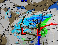
In what could be the biggest snowfall of the season will get underway later this afternoon. Today will see increasing clouds and somewhat mild temperatures, especially compared to the upcoming week, with pleasant temperatures. The temperatures may result in the precipitation starting off as some light rain or mix of rain and snow briefly. Once the precipitation starts to get heavier and nightfall approaches any mixed precipitation will go over to all snow.

NWS snow forecast

Timing: Look for snow or mixed precipitation to start around 3-4 pm from SW to NE.

Peak: Look for the heaviest snow, perhaps approaching 1″ per hour, from around 7 pm to 1 am.

End: Snow should finish before sunrise

Western New Jersey is in the bullseye of heaviest snow for this storm. Some areas just to the south and east of us may actually see some enhancement from thunderstorm or two. If you hear or see this, you will automatically know your in a bonus snow area and can add on a few inches of snow!

My forecast remains 4-8″ for most areas with locally higher amounts where the heavy snow bands setup.

NWS watches and warning

Winter Storm Warning is in place for all areas of western New Jersey.

After this storm passes, much colder and breezy weather will be in store for the new week. Look at the forecast low temperatures in the single digits Tuesday, Wednesday and Thursday mornings!

Make sure you remove any snow from areas that need to have it removed or else it will be frozen solid in place for most of the upcoming week.

Any I hope no one put away the winter coats, scarfs and boot – you will need them this week!

19. January 2019 · Comments Off on Saturday Morning Storm Update · Categories: snow, winter · Tags: , , , ,
NWS snow forecast

The trend in the past 12 hours has been a warmer one for the upcoming storm. Overnight temperatures did not go as low as originally thought. Current temperatures are at freezing and should rise into the mid to upper 30’s today. Even though winds are calm now, they will start blowing out of the warmer east direction. Winds above us are forecast to blow out of the warm southerly direction. All of these factory should result in us receiving less snow and more rain. The good news is this should minimize any icing risks for our area.

Another trend for less snow is short range computer models are showing the approaching snow this afternoon arriving to our north and west initially missing most of our area. The front-end of the storm is where I expected most of our accumulating snow. If this stays to our north, we will receive even less snow.

Look for light snow to move into our area later this afternoon. It could be mixing with some rain or sleet pellets at the beginning but should changeover to all snow. Then expect snow to start mixing with and then change to sleet around 9 pm. Then rain will mix in and we should be changed over to all rain before midnight with rain continuing heavy at times overnight. This timeline will be delayed further to the north.

Based on what I’m seeing now I’m going to forecast 1-3″ for southern and central locations and 3-6″ further to the north where the changeover will take longer and the snow will start earlier.

Even with this warmer forecast, we will still have a sharply colder and windy day on Sunday. Any early morning rain may change back briefly to snow and then end. Winds will pick up and the temperature will start to sharply fall as the day progresses. Look for temperatures to be in the teen by evening.

A winter weather advisory is in effect for Hunterdon county and points east. Winter storm warning for Warren and above.

20. March 2018 · Comments Off on Winter Storm Warnings Posted for Wednesday · Categories: snow · Tags: , , ,

Current Warnings

As expected, the Winter Storm Watch for our area has been upgraded to a Warning:

URGENT - WINTER WEATHER MESSAGE
National Weather Service Mount Holly NJ
1009 AM EDT Tue Mar 20 2018

...Major Coastal Storm to Affect the Region Through Wednesday Night...

.A pair of low pressure systems today will consolidate into one major coastal storm late tonight and Wednesday. This is expected
to bring significant impacts to our region, starting with areas of mixed precipitation today and tonight followed by significant
snowfall on Wednesday. Unnecessary travel Wednesday afternoon and evening is strongly discouraged.

NJZ001-007>010-012>015-210215-
/O.CON.KPHI.WS.W.0007.180320T2200Z-180322T0600Z/
Sussex-Warren-Morris-Hunterdon-Somerset-Middlesex-Western Monmouth-Eastern Monmouth-Mercer-
Including the cities of Newton, Washington, Morristown, Flemington, Somerville, New Brunswick, Freehold, Sandy Hook, and Trenton
1009 AM EDT Tue Mar 20 2018

...WINTER STORM WARNING REMAINS IN EFFECT FROM 6 PM THIS EVENING TO 2 AM EDT THURSDAY...

* WHAT...Heavy mixed precipitation expected. Total snow   accumulations of 11 to 15 inches are expected. Snow may mix with
  sleet and freezing rain in central New Jersey. In addition,   north to northeast winds will gust 25 to 40 mph at times.

* WHERE...Portions of central, northern and northwest New Jersey.

* WHEN...From 6 PM this evening to 2 AM EDT Thursday. Sleet and   freezing rain are most likely this evening in central New Jersey
  before snow becomes the dominant type late tonight into   Wednesday. Snow will gradually taper off from west to east late
  Wednesday evening.

* ADDITIONAL DETAILS...Travel will be very difficult to   impossible, especially Wednesday afternoon and evening. Be   prepared for significant reductions in visibility at times.
  Power outages and tree damage may occur owing to the weight of   the snow.

PRECAUTIONARY/PREPAREDNESS ACTIONS...

A Winter Storm Warning means significant amounts of snow, sleet and ice will make travel very hazardous or impossible. The latest
road conditions for the state you are calling from can be obtained by calling 5 1 1.
17. February 2018 · Comments Off on Winter Storm Warnings Issued · Categories: snow · Tags:

The NWS has upgraded the Winter Weather Advisory to Winter Storm Warning. Rightfully snow as much more snow is falling that was predicted

Sussex-Warren-Morris-Hunterdon-Somerset-Carbon-Monroe-Berks-
Lehigh-Northampton-Western Montgomery-Upper Bucks-
Including the cities of Newton, Washington, Morristown,
Flemington, Somerville, Jim Thorpe, Stroudsburg, Reading,
Allentown, Bethlehem, Easton, Collegeville, Pottstown, Chalfont,
and Perkasie
741 PM EST Sat Feb 17 2018

...WINTER STORM WARNING IN EFFECT UNTIL 4 AM EST SUNDAY...

* WHAT...Heavy snow. Total snow accumulations of around 6 inches
  are expected.

* WHERE...Portions of northern and northwest New Jersey and east
  central, northeast and southeast Pennsylvania.

* WHEN...Until 4 AM EST Sunday.

* ADDITIONAL DETAILS...Plan on difficult travel conditions. Be
  prepared for significant reductions in visibility at times. The
  snow may fall at 1 to 2 inches per hour at times in parts of the
  region, resulting in rapidly deteriorating road conditions.

PRECAUTIONARY/PREPAREDNESS ACTIONS...

A Winter Storm Warning for snow means severe winter weather
conditions will make travel very hazardous or impossible. If you
must travel, keep an extra flashlight, food and water in your
vehicle in case of an emergency. The latest road conditions for
the state you are calling from can be obtained by calling 5 1 1.
08. February 2017 · Comments Off on Storm Update Wednesday Evening · Categories: snow · Tags: ,

Radar shows snow approaching from western PA

Radar shows snow approaching from western PA

The snow in the western third of PA will continue moving to the east and should arrive in western NJ by 1- 3 am.

Short range computer model forecast

Short range computer model forecast

As we move within 24 hours of an event, meteorologists change their focus to short range computer models. These tools are updated frequently instead of 6 or 12 hours but their forecast duration is 24 hours or less.

The above model shows western New Jersey will on track for a 4-8″ snow fall.

Move of the steadiest and heaviest snow should be done by mid day. This will be a fast moving storm. The peak period will be from about 5 am until 10 am.

08. February 2017 · Comments Off on Winter Storm Warning Thursday · Categories: snow, winter · Tags:

Snow totals for Thursday

Snow totals for Thursday

As expected the NWS has changed the Watch to a Warning that is in effect from midnight tonight until 4 pm Thursday. The brunt of the storm appears to be 4 am – 10 am.

The NWS is forecasting 6-10″ of snow. At this point I’m sticking with my 4-8″ forecast. Higher amounts are certainly possible if everything comes into place. Snow should start tapering off to snow showers around mid day Thursday which will allow crews to get out and clean up.

Here are the details in the Winter Storm Warning:

URGENT - WINTER WEATHER MESSAGE
National Weather Service Mount Holly NJ
948 AM EST Wed Feb 8 2017

NJZ001-007>010-012-013-015-PAZ054-055-060>062-101>106-090300-
/O.CON.KPHI.WS.W.0002.170209T0500Z-170209T2100Z/
Sussex-Warren-Morris-Hunterdon-Somerset-Middlesex-
Western Monmouth-Mercer-Carbon-Monroe-Berks-Lehigh-Northampton-
Western Chester-Eastern Chester-Western Montgomery-
Eastern Montgomery-Upper Bucks-Lower Bucks-
Including the cities of Newton, Washington, Morristown,
Flemington, Somerville, New Brunswick, Freehold, Trenton,
Jim Thorpe, Stroudsburg, Reading, Allentown, Bethlehem, Easton,
Honey Brook, Oxford, West Chester, Kennett Square, Collegeville,
Pottstown, Norristown, Lansdale, Chalfont, Perkasie, Morrisville,
and Doylestown
948 AM EST Wed Feb 8 2017

...WINTER STORM WARNING REMAINS IN EFFECT FROM MIDNIGHT TONIGHT
TO 4 PM EST THURSDAY...

* ACCUMULATIONS...Snow accumulation of 6 to 10 inches.

* LOCATIONS...Eastern Pennsylvania and central and northern New
  Jersey.

* HAZARD TYPES...Heavy snow.

* VISIBILITIES...One quarter mile or less at times.

* TIMING...A wintry mix will overspread the area from the west
  near midnight reaching the northern New Jersey coast by 4 am.
  The event will likely begin as snow north of the I-78
  corridor. Elsewhere, rain will change over to snow from
  northwest to southeast into early Thursday morning. Sleet may
  mix in briefly during the transition from rain to snow. The
  snow likely will be heavy for a time Thursday morning before
  tapering off quickly from west to east during midday or the
  afternoon.

* IMPACTS...The heavy snow will make many roads potentially
  impassable for several hours during the worst part of the
  storm which should be 5 am to 10 am. There may be widespread
  power outages due to the weight of the snow on tree limbs and
  power lines. The threat for power outages will be less where
  temperatures are mostly below 30 degrees during the snow.

* WINDS...North 10 to 20 mph with gusts up to 30 mph.

* TEMPERATURES...falling into the 20s over most of this area
  during the snow before a slight recovery in the afternoon.

PRECAUTIONARY/PREPAREDNESS ACTIONS...

A Winter Storm Warning for heavy snow means severe winter weather
conditions are expected or occurring.  Significant amounts of
snow are forecast that will make travel dangerous. Only travel in
an emergency. If you must travel...keep an extra flashlight...
food...and water in your vehicle in case of an emergency.

Report snow and ice accumulation to the National Weather Service
by calling our trained spotter line...posting to the NWS Mount
Holly Facebook page...or using Twitter.

Snowfall and ice accumulation forecast maps in addition to
experimental probabilistic snowfall information for the latest
event are available online at www.weather.gov/phi/winter
22. January 2016 · Comments Off on Late Night Winter Storm Update · Categories: snow, winter · Tags: , ,

Surface

As of 11:30 pm 1.5″ of snow in Stewartsville, NJ. Winds are still on the light side but that will change tomorrow. Look for snow to continue overnight heavy at times, especially from 3 am on. In these heavier bands 1-3″ of snow will fall EACH HOUR!

The storm continues to over perform. Based on latest information available I’m forecasting 8-12 in northern areas and 12-18″ in central and southern sections of western New Jersey.

the coastal low pressure is starting to take over and become the primary low. The storm continues to move further north that originally thought hence the higher snow totals for our area.

mcd0056

Next update will be Saturday morning!

22. January 2016 · Comments Off on Details On Weekend Snowstorm · Categories: snow, weather discussion, weather forecast, winter · Tags: , ,


12604720_10153820409136866_17308852647168838_o

The National Weather Service has upgraded the Winter Storm watch to a Warning which was expected.

Timing: While some light snow or flurries could start before midnight tonight I expect the snow to start around midnight. If you like to look at radar on the internet, you WILL see snow on the radar BEFORE midnight. But it won’t reach the ground. The air mass we are in right now is COLD and DRY. It will take a while for it to “moisten up.”

How much: My forecast for western New Jersey continues at 6-12″ – less to the north and more to the south. Northern areas of western New Jersey could be closer to 3-6″ while southern areas closer to a foot or slightly more. You will not have to go that further south to see a nice increase in snowfall.

How long: Look for the snow to last about 24 hours so it should start to taper off around midnight or the early morning hours of Sunday morning

Winds: Will be noticeable. Closer to the shore they will be very windy with gusts 40-60 mph. In western New Jersey we could see wind gust to 30-40 mph at times. Once we have snow on the ground this will cause snow to blow and drift at times. That combined with snow falling will reduce visibility at times. We probably won’t meet the criteria for a blizzard but will be close at times.

Intensity: Snow rates will vary. There will be times when it will only be snowing lightly. Then there will be times it will be near blizzard like conditions. This storm will have snow in bands that will vary from light to heavy. there *may* even be thunder snow!

Concerns: I’m concerned with the sharp cut off of snow in northern areas. Any change to the storm track will drastically change snow amounts in all areas. We could easily change snow amounts be 6″ in either direction if the storm deviates from the expected track.

Updates: I will post updates today and throughout the weekend on the storm. Besides this blog you can also follow me on twitter: dabour

05. March 2015 · Comments Off on Thursday Mid Morning Update · Categories: snow, weather discussion, weather forecast, winter · Tags: , , ,

image

4” of new snow has already fallen in Stewartsville as of 10:20 this morning. It’s been snowing moderately to occasionally heavy most of the morning. At the very least, I think we will be at the high end of my 3-6” forecast. There will be locations (perhaps many of us) that will go over 6” before all said and done. The NWS sees this trend too and raised the Winter Weather advisory that was previously in effect for Warren county NJ to a Winter Storm Warning and forecasting 4-8” of snow. Hunterdon county was already in a Winter Storm Warning.

In looking at the radar above, most of the echo’s are moving to the ENE. The back edge of the line to the north is also moving SLOWLY to the SE. There are still plenty of areas of darker blue heading our way from eastern PA. These will give us 1”/hour snow rates at time late morning into the early afternoon.

I still think the snow will lighten up this afternoon but it doesn’t appear to be in any rush to do so…

26. January 2015 · Comments Off on Winter Storm Monday into Tuesday · Categories: weather discussion · Tags: , , ,

10923684_999790576717198_3018690728063537364_o

I’m back from my trip, somewhat well-rested and have looked at some weather data. I like the map above from the National Weather Service (NWS). For western new jersey these are my thought: 6-12”of snow from west to east. A little further to the east will be 12-18”. Further to the east, extreme northeastern NJ into NYC and Long Island into new england, 18”+

This will be a cold storm with gusty winds. In fact Long Island will see some near hurricane wind gusts during the storm, hence blizzard warnings.

For western New Jersey we are under a Winter Storm Warning. Look for occasional snow today of various intensities throughout the day. The snow should become heavier and steadier as the day wears on. The worse of it should be tonight and overnight.

I’ll have other updates throughout the day as new information becomes available and time permits

Social Network Integration by Acurax Social Media Branding Company
Visit Us On TwitterVisit Us On FacebookVisit Us On PinterestVisit Us On YoutubeVisit Us On Instagram