03. January 2018 · Comments Off on Blizzard Warning Issued for NJ Coast · Categories: snow, winter · Tags:
NWS has issued a blizzard warning for the NJ Coast

NWS has issued a blizzard warning for the NJ Coast

The NWS has increased snow forecast to 3-4"

The NWS has increased snow forecast to 3-4″

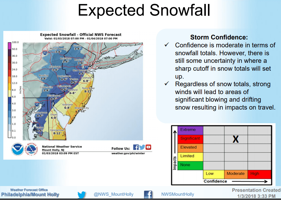
I support this forecast. The key to how much snow western New Jersey receives is 1) how close to the coast the storm is and 2) where the heavy snow bands setup. In strong storms like this one the snow falls in bands. Sometimes these bands move around so that a large area receives heavier snow. Sometimes they don’t. This is something we’ll have to watch tomorrow and I’ll have frequent updates.

09. February 2017 · Comments Off on Storm Winding Down · Categories: snow, winter · Tags:

The snow is just about ended in Stewartsville as of 9:45. 6.4″ was measured around 9:30 and I only expect a few tenths additional if any.

The light blue you still see on the radar to our west is very light snow or flurries. I’m hearing some reports of breaks in the clouds in eastern PA already so conditions should improve from this point forward.

What won’t improve too much today is the temperature and wind. I expect the temperature to level off a little but then start dropping again later today. So anything that does melt will refreeze tonight. Wind will pick up and be gusty out of the NW.

I’m pretty satisfied with my 4-8″ forecast!

09. February 2017 · Comments Off on Early Morning Update · Categories: snow · Tags:

Surprise, surprise it’s snowing out! 2.3″ was measured in Stewartsville as of 5:30 am. Moderate snow is falling as is the temperature, currently at 30.7 and falling.

Here is the radar as of 5:30 am. Notice the lighter amounts of snow near Reading. I didn’t expect to see it getting this light this early. I think we will only see the heaviest accumulating snow until 8 or 9 am. After that it will be lighter and not accumulate as much.

At this point I’m happy with my 4-8″ snow forecast for western New Jersey.

08. February 2017 · Comments Off on Storm Update Wednesday Evening · Categories: snow · Tags: ,
Radar shows snow approaching from western PA

Radar shows snow approaching from western PA

The snow in the western third of PA will continue moving to the east and should arrive in western NJ by 1- 3 am.

Short range computer model forecast

Short range computer model forecast

As we move within 24 hours of an event, meteorologists change their focus to short range computer models. These tools are updated frequently instead of 6 or 12 hours but their forecast duration is 24 hours or less.

The above model shows western New Jersey will on track for a 4-8″ snow fall.

Move of the steadiest and heaviest snow should be done by mid day. This will be a fast moving storm. The peak period will be from about 5 am until 10 am.

06. February 2017 · Comments Off on Wednesday Night-Thursday Morning Snow? · Categories: snow, winter · Tags:

After the rain on Tuesday into Wednesday morning, then we need to turn our attention for the *potential* for some snow on late Wednesday night into Thursday morning. A cold front will come through western New Jersey on Wednesday to end the rain. A storm system may form on the end of the front and move east along the front bringing western New Jersey some snow. How much and where still needs to be decided. A couple of days ago the possibility wasn’t even there but now more and more computer models are suggesting the *potential* for this. If it happens it looks like a few inches of snow for western New Jersey or a plow-able event.

04. March 2015 · Comments Off on Wednesday Evening Update on Thursday Snow · Categories: snow, weather discussion, winter · Tags: ,

14038_10155376111065122_5435027462606150488_n

I just finished looking at the latest weather data for our next snow maker. Some of it is pointing to less snow, and some of it says more. So I’m going to hold course and continue my 3-6” forecast for western New Jersey. It looks like heavier amounts of snow will fall from southern Hunterdon county on south. Specifically I-195 on south except right near the coast.

The NWS map above shows the minimum and maximum they are forecasting. There is potential for us to go over the 6” I’m forecasting. If we do it will be the single largest snowfall we’ve had this season!

image

Rain has resumed  as of 8pm. Temperatures are starting to fall from the daytime high of 44. We are now down to 38 degrees and falling:

image

I expect sleet and wet snow to start mixing in before midnight and to change over completely not to far after that.

I’ll update again in the morning.

Floating Social Media Icons by Acurax Wordpress Designers
Visit Us On TwitterVisit Us On FacebookVisit Us On PinterestVisit Us On YoutubeVisit Us On Instagram