Dangerous cold continues today into the weekend. High temperatures will be in the teens and overnight lows in the single digits near zero, if not below zero later in the week.
As we look and temperature trends into February, both the 6-10 day and 8-14 day temperature outlook are below normal. It could be worse – you could be vacationing in Florida this weekend as they will have extensive freeze warnings down there.
As we turn our attention to the weekend and beyond, there will be a strong storm that will form south of us. That is a given. The big question is how far north it will travel or will it mostly go out into the Atlantic. As seen in the above graphic, the NWS is leaning towards the next storm staying mostly to our east. But also note that it has hazardous cold from 1/30-2/1. Brrr.
Even though parts of our area received rain on August 23rd, that was nearly 2 weeks ago!
Expected rainfall tonight into Tuesday
Even though our Labor Day weather is featuring filtered sunshine this morning, look for clouds to increase an lower with increasing showers as the day wears on. The rainiest period will be overnight into Tuesday morning
It certainly won’t feel like late March today – more like January! Gusty winds, cold wind chills and perhaps even some snow showers!!
Low temperature forecast Monday morning
And the hunt for Spring 2022 continues. If you don’t like today, you’re not going to like Monday either. Overnight lows the next two nights are going to be in the upper teens and low 20’s! If you turned on your outdoor water faucets, you might want to turn them off!
Monday high temperature forecast
Monday temperatures will not get out of the teens. The gusty winds will make it feel even colder. Normal highs this time of year are the mid 50’s.
Temperatures will slowly start to recover on Tuesday with more seasonable temperatures on Thursday and beyond. With the warmer temperatures come increasing chances of rain.
Astronomical spring began at 11:33 AM today, Sunday, March 20, 2022. Hopefully, everyone took deep breaths of the unseasonably warm temperatures recently. Normal high temperatures this time of year are only in the low 50’s.
The CPC outlook above indicates below average temperatures to close out this month and begin next. #NJwx
Cooler and windy conditions this weekend and early this new week are not welcome compared to the warmer weather of last week. Winter will let us know the calendar does not turn to Spring until Saturday. We could see some light wintry mix on Tuesday. Early Tuesday morning, as well as late afternoon and evening, are the best times to see any wintry mix. Other times it will just be cold rain showers. If anything does accumulate, it will be on colder, shaded surfaces of a coating to less than 1″
Wet weather moves back in on Thursday afternoon. This has the potential to give our area the first decent rainfall in over two weeks.
Looking ahead to the weekend, the weather looks seasonable with warmer temperatures back in the forecast for next week this time
After a chilly morning, Sunday will feature sunshine. We should see some increase in clouds later in the day with our next weather system approaching.
NWS snow forecast for Monday
The Monday morning commute should be fine but looks for snow to once again fall from the skies starting late morning. There is some good news here for folks that had enough of the cold and snow this winter. The first bit of good news is this should only last for 4 hours. The second bit of good news is that most if not all of the snow accumulation should be on colder surfaces (cars, garbage cans, tree branches, etc..) – roadways should be fine. Since this will be happening during the day and we are now in late February, the higher sun angle should help to keep most roadways only in need of some salt. Monday’s snow is the result of a cold front passing through and not from a storm.
The snow forecast graphic above shows a 1-3″ snow forecast for our area. As usual, there will be less to the south and more to the north. If every snowflake that fell accumulated, I agree with the above. However, I don’t think most of us will see that much.
7 Day forecast
After Monday, warmer weather closer to normal will prevail with Wednesday looking like the nicest day!
Stewartsville Thursday morning as snow starts falling again
Another snowfall for 2021. We should all be used to this at this point. So far only a tenth of an inch at 7 am with more on the way.
NWS Snow forecast
The heavier snow bands appear to be setting up south of our area in the central-west area of NJ. As a result the NWS has shifted their forecast area of snow for 6-8″ to those areas. That is represented in the graphic above.
There is still a chance of some sleet getting mixed in or perhaps changing over to later today and this evening.
Most of the heavier snow will fall today during the day. the snow should lighten up later today and overnight. We should still see some periods of light snow and snow showers Friday morning. At this time I don’t see too much additional resulting from that.
The National Weather Service Mt Holly Office has issued a Winter Storm Watch for our next winter storm from late Wednesday into Friday afternoon.
WINTER STORM WATCH IN EFFECT FROM LATE WEDNESDAY NIGHT THROUGH FRIDAY AFTERNOON
* WHAT – Heavy mixed precipitation possible Total snow and sleet accumulations of 5 to 8 inches
* WHERE – Portions of northern and northwest New Jersey and east central, northeast and southeast Pennsylvania
Based on what I’m seeing at the moments I’m going with 4-8″ snow forecast. This could mix with or change to sleet at times, especially southern locations
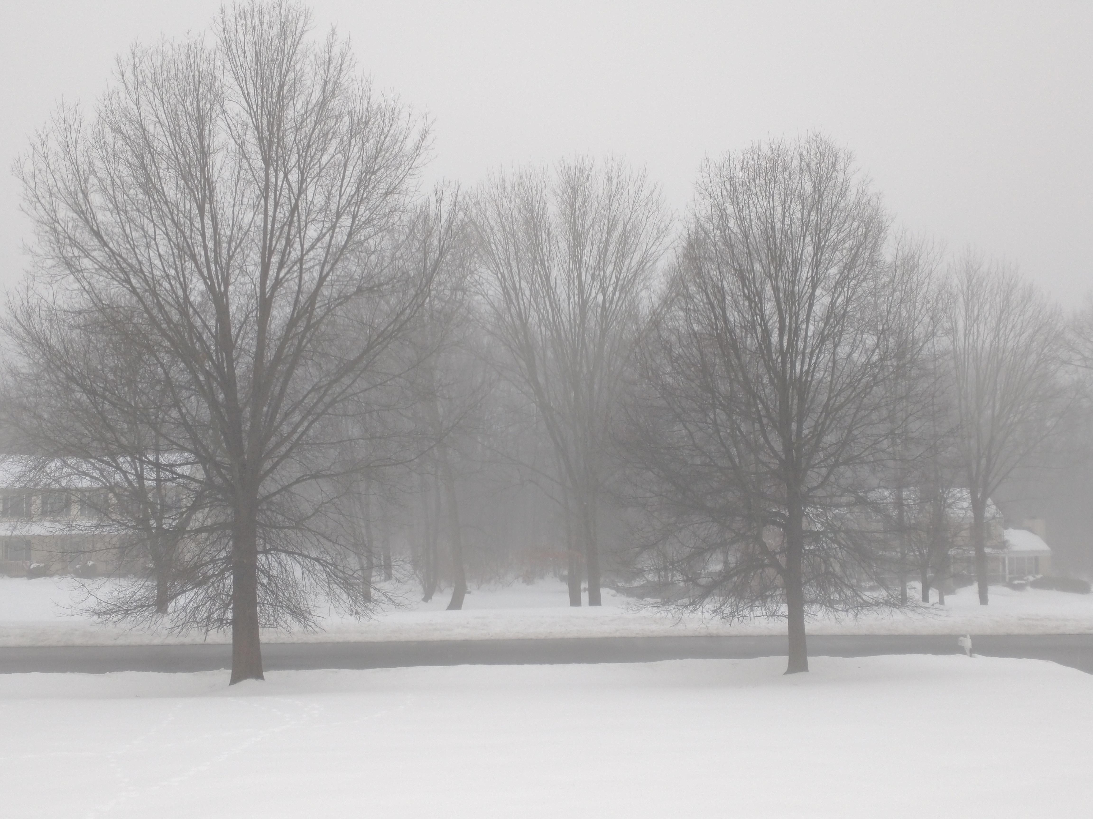
Fog in Stewartsville Tuesday morning after overnight rain
Thankfully the ice threat never materialized in southern locations overnight. Much warmer air overtook the area as the storm system passed to our west and we were on the “warm” side of the storm.
When warmer air hits the cold snow pack, it common to make fog as is seen in many areas this morning
Ice? I did not see nay in Stewartsville area overnight as the temperature was just above freezing all night. Anyone get ice? If so please let me know in the comments
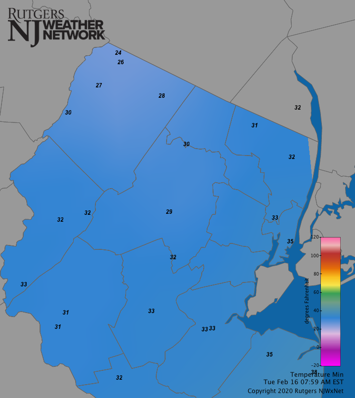
Overnight lows in northern NJ tuesday morning, Feb. 16, 2021
As shown on the above map, overnight low temperatures. I’m sure many of these were recorded just after midnight
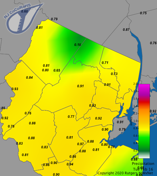
Overnight rainfall in northern NJ, Feb. 16, 2021
And then there’s the rain. Many areas received at least 3/4″ of an inch and some more. This should put a nice dent in the snowpack. But don’t worry snow lovers – reinforcements are on the way!
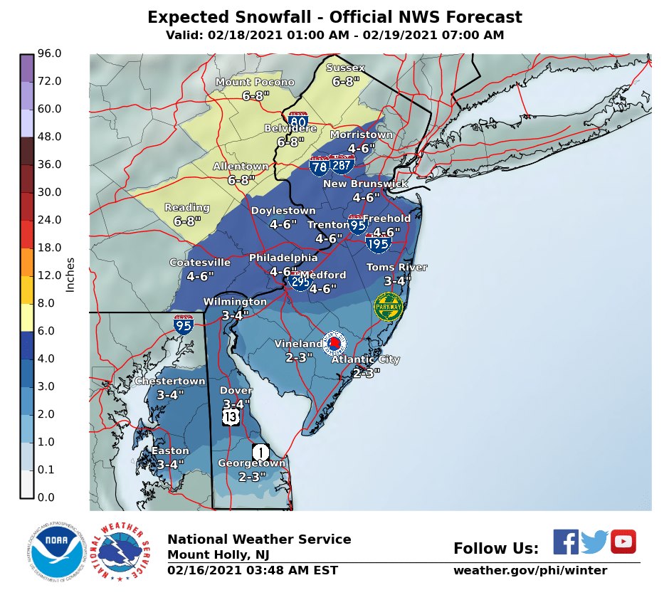
NWS snow forecast for Thursday
Speaking of snow, our next parade of storms will arrive on Thursday. At this point this storm appears to be somewhat colder and snowier than the last storm. Look for snow to arrive Thursday morning and last a good part of the day. The snow looks to be plowable and be in the 4-8″ range – more to the north and less to the south.
Warmer air looks to arrive thursday night and change many areas (especially south) to a wintry mix of first sleet and then possibly freezing rain.
We’ll keep an eye on this and update accordingly.
Some good news? After this storm the atmosphere looks to “take a break” for a little while so expect some calmer and seasonable conditions. But remember: it’s still winter and still February!
In our rapid succession of snow threats, we have two more that will visit our area. For the most part, these will remain to the south of our area. But we may still get some accumulating snow.
The first one will arrive late Wednesday night or very early Thursday morning. The second one will be almost 24 hours later.
Both of these will impact southern locations more than northern locations.
I’m expecting a coating to 2″ of snow with less to the north and more to the south.
Looking ahead, there’s another chance of wintry weather late Saturday night into SUnday morning. If this verifies, this will be the second Sunday morning in a row of wintry weather. Right now this looks relatively light but could feature some mixed precipitation.


Recent Comments