16. February 2021 · Comments Off on Ice Threat Melts; More Snow Thursday · Categories: snow, weather discussion · Tags: ,
Fog in Stewartsville Tuesday morning after overnight rain

Thankfully the ice threat never materialized in southern locations overnight. Much warmer air overtook the area as the storm system passed to our west and we were on the “warm” side of the storm.

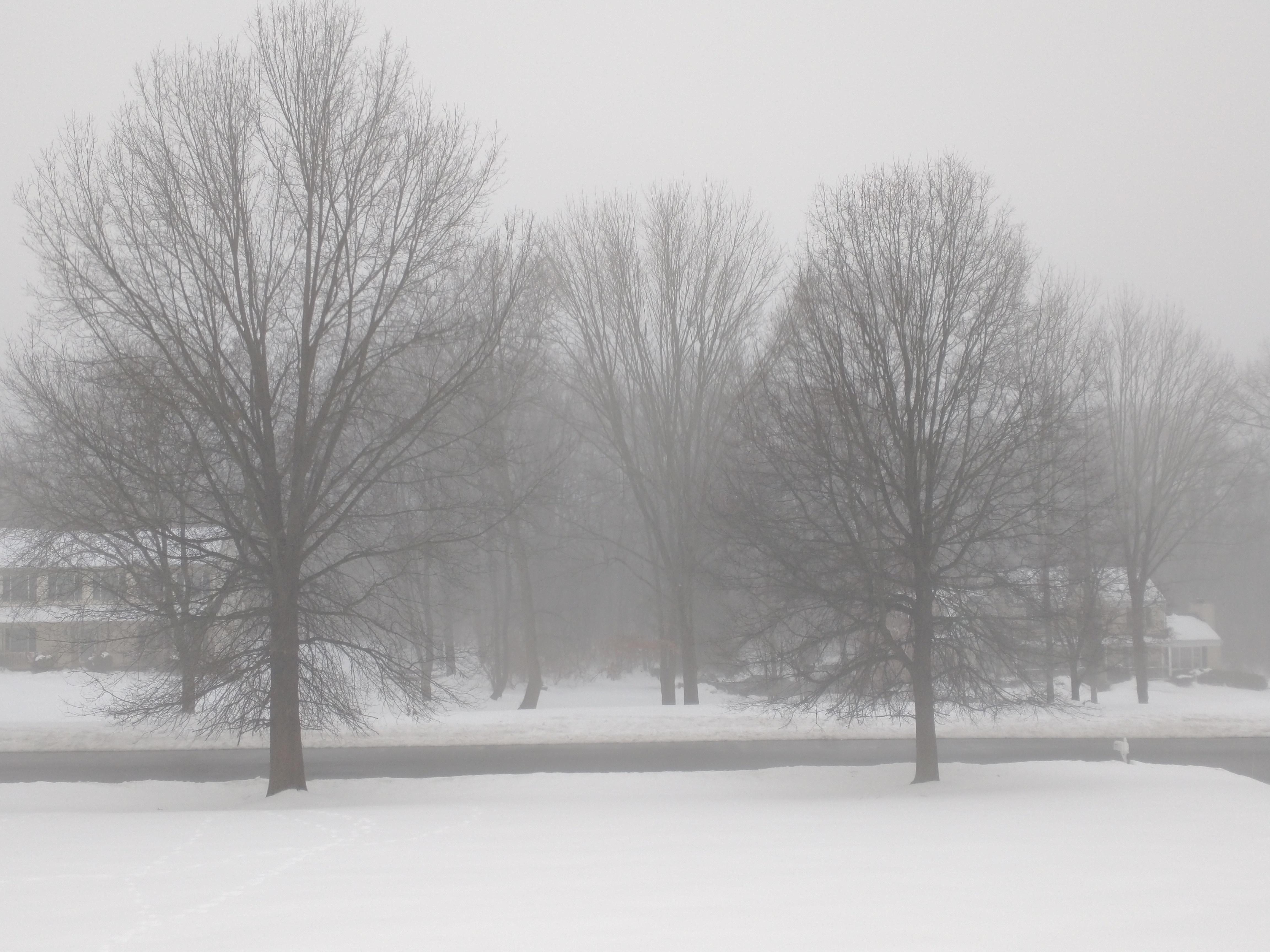
When warmer air hits the cold snow pack, it common to make fog as is seen in many areas this morning

Ice? I did not see nay in Stewartsville area overnight as the temperature was just above freezing all night. Anyone get ice? If so please let me know in the comments

Overnight lows in northern NJ tuesday morning, Feb. 16, 2021

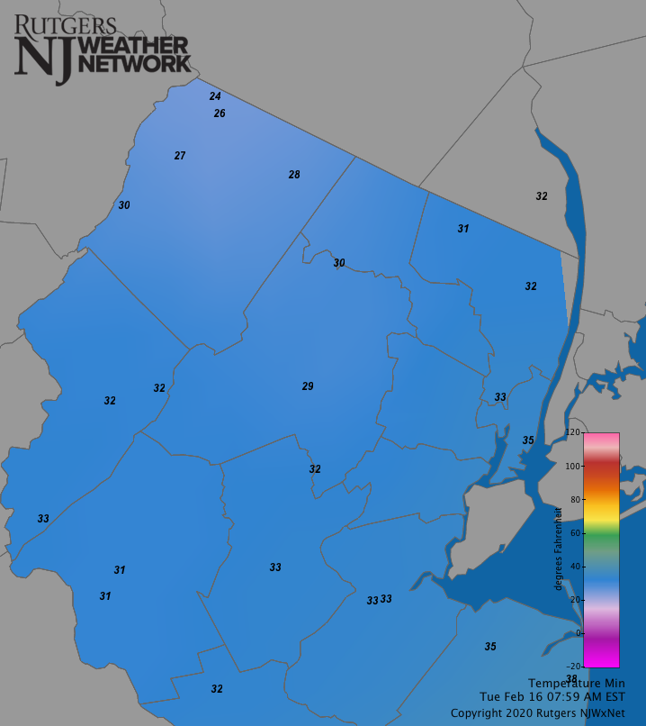
As shown on the above map, overnight low temperatures. I’m sure many of these were recorded just after midnight

Overnight rainfall in northern NJ, Feb. 16, 2021

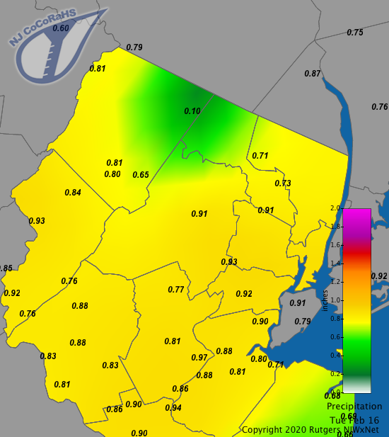
And then there’s the rain. Many areas received at least 3/4″ of an inch and some more. This should put a nice dent in the snowpack. But don’t worry snow lovers – reinforcements are on the way!

NWS snow forecast for Thursday

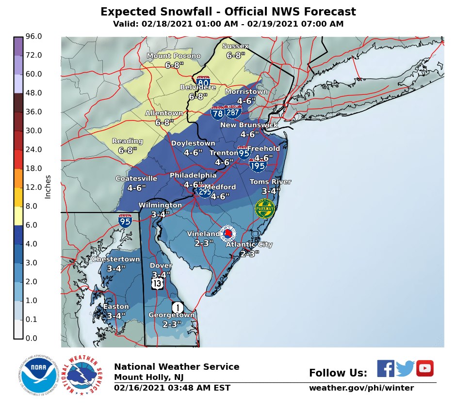
Speaking of snow, our next parade of storms will arrive on Thursday. At this point this storm appears to be somewhat colder and snowier than the last storm. Look for snow to arrive Thursday morning and last a good part of the day. The snow looks to be plowable and be in the 4-8″ range – more to the north and less to the south.

Warmer air looks to arrive thursday night and change many areas (especially south) to a wintry mix of first sleet and then possibly freezing rain.

We’ll keep an eye on this and update accordingly.

Some good news? After this storm the atmosphere looks to “take a break” for a little while so expect some calmer and seasonable conditions. But remember: it’s still winter and still February!

04. February 2020 · Comments Off on Winter Weather Advisory For Freezing Rain · Categories: winter · Tags: , , ,

A Winter Weather Advisory is up for most of western New Jersey for Wednesday night into early Thursday morning. This will primarily be at an elevation from 1000′ and above but there could also be some in the valley locations. This will eventually change over to all rain. The map above shows the potential amounts of freezing rain ending at 1 pm Thursday

18. January 2019 · Comments Off on Friday Morning Update on Weekend Storm · Categories: snow, winter · Tags: , ,
NWS forecast for snow

I wanted to post an update based on trends and data from the past 12 hours or so. I will continue to monitor for changes today and if anything significant will past later on.

The computer weather models have trended slightly colder for our area. At the same time they are also trending more warmer air above us for a longer period of time.

So what does this all mean? I think a changeover to plain rain is reduced except for possible extreme SE locations. The NWS has extended the WInter Storm Watches to also include Upper Bucks in PA and Somerset in NJ

NWS ice forecast

But warm air above us for an extended period of time will give us a lot of sleet and possibly freezing rain.

At this time I’m still predicting 4-8″ but seriously thinking of lowering to 3-6.” Most of the snow we will fall at the beginning of the storm – from when it starts until about 1 am Sunday. The snow start time looks to be late afternoon Saturday.

I’m still looking for sharply falling temperatures Sunday afternoon and night. Precipitation could end a little sooner than originally thought on Sunday. That will be something I will be looking at along with does it change back to snow. Traditionally when storms do go from snow to rain/mix back to snow very little snow falls on the backend.

Sunday night and Monday will be brutal temperature wise with well below zero wind chills and just above zero temperature. It is January after all…

08. January 2018 · Comments Off on More Sleet and Freezing Rain Than Snow · Categories: winter · Tags: ,

Sleet and freezing rain on the radar

Sleet and freezing rain on the radar

Even though its been so cold for the last 2 weeks, warmer air has worked into the air above the ground changing the snow to sleet and freezing rain as seen in the pink on the above radar.

So prepare yourself for more mixed precipitation than snow this afternoon

17. December 2016 · Comments Off on Freezing Rain Next Several Hours · Categories: winter · Tags: ,

What my car looks like only being out in freezing rain for 20 minutes

What my car looks like only being out in freezing rain for 20 minutes

All freezing rain now in Stewartsville and most central and southern areas of western New Jersey. Look for any areas that are still getting sleet to go over to freezing rain shortly.

It’s now a race between the precipitation ending or warmer air arriving to see which gets here first. Let’s hope noon time or before is the ending of either.

Roads are no good so stay in if possible

Back end of precipitation in Harrisburg as of 9am

Back end of precipitation in Harrisburg as of 9am

17. December 2016 · Comments Off on Frozen Precipitation To Taper Off By Mid Day · Categories: snow, weather forecast, winter · Tags: , ,

Snow covered streets in Stewartsville

Snow covered streets in Stewartsville

The snow has already changed over to sleet in most sections of southern western new jersey. Look for all areas to go to sleet and then even freezing rain before ending by mid day.

Stewartsville received 0.8″ of new snow/sleet so far.

NWS forecast for ice

NWS forecast for ice

Untreated roads will be icy this morning so please slow down and take your time until the temperature warms up and the roads and walkways improve

16. February 2016 · Comments Off on Heavy Rain On The Way · Categories: precipitation, winter · Tags: , ,

Snow outside encased in icy crust this morning in western New Jersey

Snow outside encased in icy crust this morning in western New Jersey

Anyone who does not have the pleasure of garaging their car will know real fast this morning that we had some freezing rain last evening. Allow extra time to scrape off the car and let it warm up.

Stewartsville received 1.4″ of snow before changing to sleet and freezing rain yesterday.


Sharp temperature rise in western New Jersey around 5 am Tuesday morning

Sharp temperature rise in western New Jersey around 5 am Tuesday morning

The temperature stayed quite cold in western New Jersey until around 5 am. Believe it or not we should top out in the mid 50’s today. Considering we were at 0 a few days ago that’s nearly a 60 degree temperature swing!

Moderate to heavy rain will be moving into western New Jersey later this morning and into the afternoon.

Moderate to heavy rain will be moving into western New Jersey later this morning and into the afternoon.

We expect to see an additional 1-2″ of rain today as all that rain on the radar above needs to pass through western New Jersey. It will remain all rain as the temperatures will be quite mild in the 50’s. Be on the lookout for localized flooding. HOpefully all the rain will melt the remaining ice on sidewalks and colder surfaces.

28. December 2015 · Comments Off on Wintry weather overnight · Categories: winter · Tags: , , , ,

StormTotalSnowWeb1

The National Weather Service (NWS) has continued their winter weather advisory for tonight into early Tuesday morning. I’m expecting precipitation to break out over western New Jersey this evening from 7 pm – 10 pm. It could start out as a cold rain in some areas. Then the rain will cool the atmosphere a little more and the rain should mix if and possibly change to sleet for a few hours. Further to the north and west (near and north of I-80), especially in elevated areas, there could be some wet snow mixed in as well.

Warmer air will eventually take over and we should see all rain by the Tuesday morning commute. The changeover will take a bit longer further to the north and west. Given how warm the ground has been recently I expect little of any accumulation. At most there could be a little slush on colder surfaces like cars.

The most important thing to keep an eye on tonight is the air temperature. As long as we remain above freezing the roads and walkways should be fine. Bit some areas further to the north and west, as well as sheltered valleys, may have pockets of colder temperatures. In these areas we might see a little bit of freezing rain after the switch-over until the warmer temperatures make it to those areas as well.

I’ll have additional updates as warranted.

03. March 2015 · Comments Off on Sleet Changed to Freezing Rain · Categories: precipitation, snow, weather discussion · Tags: , ,

image

temperature now up to 28 degrees and *slowly* climbing in western New Jersey. Hopefully by 1 am will be above freezing and can have plain rain. 0.9” total of snow and sleet.

03. March 2015 · Comments Off on Winter Precipitation Graphic · Categories: snow, winter · Tags: , , , ,

10930992_856846761025578_3255655532733196150_n

Figured tonight would be a good time to repost this graphic that explains the difference between snow, sleet and freezing rain.

And you can only get hail in thunderstorms which are typically in warmer weather. Hail and sleet are different.

So right now, even though we are well below freezing at the surface in western New Jersey (mid 20’s), there is a warmer layer above us that is melting the snow. But there is still enough cold air near the surface to re-freeze the rain and turn it into snow. Once a snow flake melts, it can’t go back to being a snow flake Sad smile

We will most likely have a period of freezing rain until all of the warmer air makes it down to the surface and gives us rain. We want that to be a short as possible. I’d rather have sleet over freezing rain…

Floating Social Media Icons by Acurax Wordpress Designers
Visit Us On TwitterVisit Us On FacebookVisit Us On PinterestVisit Us On YoutubeVisit Us On Instagram