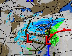
In what could be the biggest snowfall of the season will get underway later this afternoon. Today will see increasing clouds and somewhat mild temperatures, especially compared to the upcoming week, with pleasant temperatures. The temperatures may result in the precipitation starting off as some light rain or mix of rain and snow briefly. Once the precipitation starts to get heavier and nightfall approaches any mixed precipitation will go over to all snow.

Timing: Look for snow or mixed precipitation to start around 3-4 pm from SW to NE.
Peak: Look for the heaviest snow, perhaps approaching 1″ per hour, from around 7 pm to 1 am.
End: Snow should finish before sunrise
Western New Jersey is in the bullseye of heaviest snow for this storm. Some areas just to the south and east of us may actually see some enhancement from thunderstorm or two. If you hear or see this, you will automatically know your in a bonus snow area and can add on a few inches of snow!
My forecast remains 4-8″ for most areas with locally higher amounts where the heavy snow bands setup.

Winter Storm Warning is in place for all areas of western New Jersey.

After this storm passes, much colder and breezy weather will be in store for the new week. Look at the forecast low temperatures in the single digits Tuesday, Wednesday and Thursday mornings!
Make sure you remove any snow from areas that need to have it removed or else it will be frozen solid in place for most of the upcoming week.
Any I hope no one put away the winter coats, scarfs and boot – you will need them this week!


Recent Comments