This afternoon with some sunshine and thankfully no more strong winds itself makes it feel much more comfortable outside
And the trend will continue. Friday will feature high temperatures in the upper 40’s to near 50. Saturday near 60! The downside is there will be more clouds than sun, but warmth is warmth. If it’s not going to snow, let us all be comfortable at least and enjoy some outdoor activities.
Signs continue to suggest the pattern change will start the last week of the month. As of right now nothing overly cold, just more seasonal for starters.
Any early morning sunshine today will be replaced with increasing and thickening clouds. Light snow should break out in southern areas by mid to late afternoon. If the precipitation arrives early enough it could even fall as light rain initially.
As seen in the map above, most of the snowfall should be in southern locations primarily south of I-78. Snow should be over just after midnight and long gone by tomorrow’s AM rush.
Wednesday will be a blustery and chilly day as colder air gets blown into our area as the storm departs. There could even be a snow shower or two at times but nothing important. Thursday is the transition day before we start another impressive warm-up for the weekend.
Even though our weather today is closer to seasonable, the medium-range forecast turns warmer again. As seen in the above graphic, the Jan 12-18th outlook is warm for the entire Eastern seaboard.
Even the closer outlook of Jan 10-14th has much above normal temperatures in store for us.
Now that I told you about the warm temperatures, believe it or not, we could see some snowflakes this week. The first will be some brief flurries or a snow shower very early Monday morning. The best chance for this will be north and west.
The second chance is early Wednesday morning. As seen in the above map we are only expecting a coating at best.
So is there any cold, snowy air at all? The answer is yes there is. Right now most of it is out west and locked up near the north pole. There are some signs that a pattern change could start in about 2 weeks that will bring some of it back down our way. But until then, enjoy the warmth!
A winter weather advisory is posted for far northern sections including Sussex County and the Poconos for some freezing rain.
This should be limited to areas far to the north as seen in the map above
Any early morning glimpses of brightness are gone and cloudy conditions will remain for the rest of today. An early look at radar shows our rain shield approaching the western New Jersey area. I was hoping the rain would hold off until mid-afternoon but I would not be surprised to see it arriving a little sooner, unfortunately.
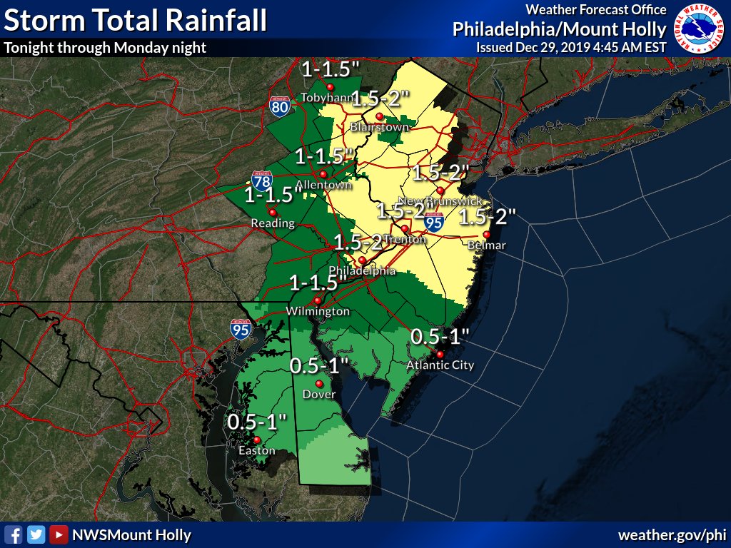
As seen in the map above the entire area should receive 3/4″ to 1.5″ of rain from later today through Monday. In fact, some showers could remain into Tuesday.
The rest of New Year’s Eve and New Year’s day looks OK but there will be a breeze but nothing too crazy.
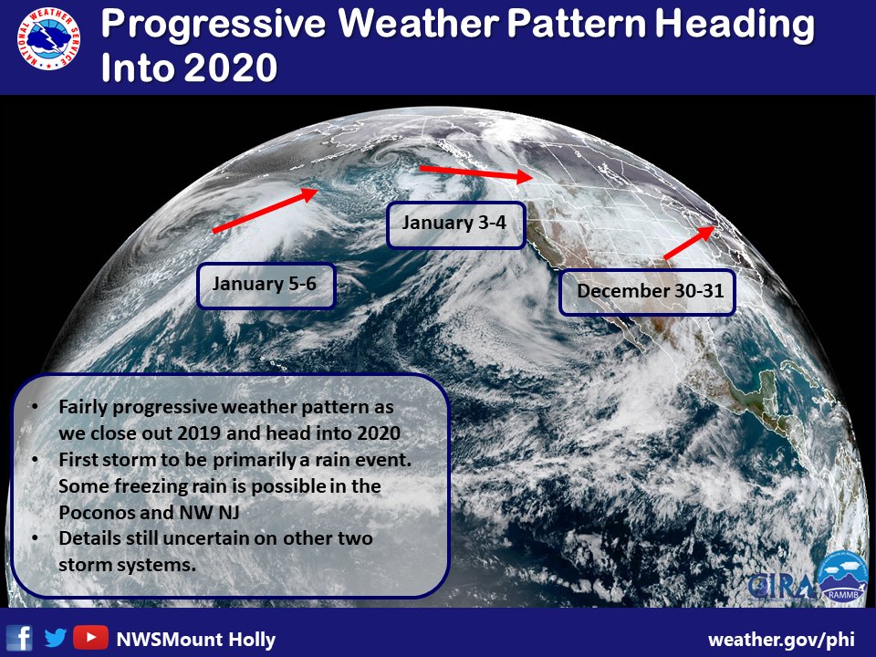
As far as January is concerned we look to be entering a more progressive pattern. Temperatures look to remain above normal into the first part of January
Rain will move into our area on Thursday. Colder temperatures will also be arriving. Usually, by the time the cold air arrives the precipitation shuts off. That will probably happen again early Friday morning but we all could see some wet snowflakes if you up early enough in the morning Friday. The best chances of seeing anything will be northern and western locations.
But the real story will be the arrival of much colder weather starting Friday and well into next week. The above map shows Friday afternoon temperatures struggling to get out of the 30’s. Combined with the wind chill it will feel much colder.
Cold weather continues right into the weekend with Saturday morning lows well down into the 20’s.
This colder than average weather looks to continue into next week. Once again we go from some days in the 70’s to winter-like conditions…
In what could be the biggest snowfall of the season will get underway later this afternoon. Today will see increasing clouds and somewhat mild temperatures, especially compared to the upcoming week, with pleasant temperatures. The temperatures may result in the precipitation starting off as some light rain or mix of rain and snow briefly. Once the precipitation starts to get heavier and nightfall approaches any mixed precipitation will go over to all snow.
NWS snow forecast
Timing: Look for snow or mixed precipitation to start around 3-4 pm from SW to NE.
Peak: Look for the heaviest snow, perhaps approaching 1″ per hour, from around 7 pm to 1 am.
End: Snow should finish before sunrise
Western New Jersey is in the bullseye of heaviest snow for this storm. Some areas just to the south and east of us may actually see some enhancement from thunderstorm or two. If you hear or see this, you will automatically know your in a bonus snow area and can add on a few inches of snow!
My forecast remains 4-8″ for most areas with locally higher amounts where the heavy snow bands setup.
NWS watches and warning
Winter Storm Warning is in place for all areas of western New Jersey.
After this storm passes, much colder and breezy weather will be in store for the new week. Look at the forecast low temperatures in the single digits Tuesday, Wednesday and Thursday mornings!
Make sure you remove any snow from areas that need to have it removed or else it will be frozen solid in place for most of the upcoming week.
Any I hope no one put away the winter coats, scarfs and boot – you will need them this week!
4.3″ of new snow fell overnight in Stewartsville and surrounding areas overnight. The snow started around midnight give or take and tapered off to flurries around 9 am.
My Spring-time flag didn’t ward off the snow
Our Winter WEather Advisory expired at 9 am this morning. But it will be soon replaced with a Winter Storm Watch that will go in effect at 1 pm Sunday afternoon.
NWS snow forecast for Sunday into Monday morning
The next storm looks to begin in our area Sunday afternoon. This storm will be the biggest and last of the series. For our area this appears to be an all snow at this time. The same areas that received the most snow today look to repeat tomorrow. The good news is the worse of the storm will be Sunday night and early Monday morning before sun-up. I anticipate schools will be closed and traveled delayed for a while Monday morning.
Based an what I’m seeing now I’m going to forecast 4-8″ of snow for the Sunday-Monday storm. The real question is will this be the biggest snow of the season for us? We received over 7″ back in November.
1 year ago today
As we are too aware, March is turning into a new extended winter season for us. The above photo was taken on this date last year. There have been several March’s in the past few years that have been cold and snowy. We certainly will have the cold part next week but I’m anticipating a return to normal and maybe even a warm up starting in around 10 days.
After a very nice recovery in temperatures yesterday (50f high in Stewartsville) today, Friday will be pleasant but not quite as warm. Clouds will be on the increase on Saturday with rain arriving in the late afternoon and early evening. The rain should start off on the light and showery side but will get heavier as the night progresses. This is the same system that will be giving a blizzard to the west of Chicago and also gave snow to the dessert Southwest. But we are on the warm side of this storm and will only see rain.
And we could see a good amount of rain too. At least 1” of rain is forecast at this point. The ground continues to be saturated from the cold weather and all the rain we have received lately. This could result in some minor flooding in the usual places.
As the storm passes the big weather story will be the strong winds that develop Sunday afternoon and evening into Monday. Wind gust will be over 40 mph.
Snow showers move into western NJ on Wednesday afternoon
Stewartsville wound up with 1.4″ of snow and sleet from the last storm. The gusty winds brought in some snow showers that sparked a snow squall warning for part of the area today.
Looking ahead nothing too out of the ordinary – no big warm ups and not arctic cold.
The the snow on Saturday afternoon holds together it should stay south of our area as it appears now. Another system will move through Sunday night. Right now this looks like some light snow. The next potential larger storm is about a week away, next Wednesday.


Recent Comments