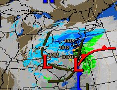
The National Weather Service has upgraded the Winter Storm watch to a Warning which was expected.
Timing: While some light snow or flurries could start before midnight tonight I expect the snow to start around midnight. If you like to look at radar on the internet, you WILL see snow on the radar BEFORE midnight. But it won’t reach the ground. The air mass we are in right now is COLD and DRY. It will take a while for it to “moisten up.”
How much: My forecast for western New Jersey continues at 6-12″ – less to the north and more to the south. Northern areas of western New Jersey could be closer to 3-6″ while southern areas closer to a foot or slightly more. You will not have to go that further south to see a nice increase in snowfall.
How long: Look for the snow to last about 24 hours so it should start to taper off around midnight or the early morning hours of Sunday morning
Winds: Will be noticeable. Closer to the shore they will be very windy with gusts 40-60 mph. In western New Jersey we could see wind gust to 30-40 mph at times. Once we have snow on the ground this will cause snow to blow and drift at times. That combined with snow falling will reduce visibility at times. We probably won’t meet the criteria for a blizzard but will be close at times.
Intensity: Snow rates will vary. There will be times when it will only be snowing lightly. Then there will be times it will be near blizzard like conditions. This storm will have snow in bands that will vary from light to heavy. there *may* even be thunder snow!
Concerns: I’m concerned with the sharp cut off of snow in northern areas. Any change to the storm track will drastically change snow amounts in all areas. We could easily change snow amounts be 6″ in either direction if the storm deviates from the expected track.
Updates: I will post updates today and throughout the weekend on the storm. Besides this blog you can also follow me on twitter: dabour
Like this:
Like Loading...


Recent Comments