22. January 2016 · Comments Off on Late Night Winter Storm Update · Categories: snow, winter · Tags: , ,

Surface

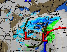
As of 11:30 pm 1.5″ of snow in Stewartsville, NJ. Winds are still on the light side but that will change tomorrow. Look for snow to continue overnight heavy at times, especially from 3 am on. In these heavier bands 1-3″ of snow will fall EACH HOUR!

The storm continues to over perform. Based on latest information available I’m forecasting 8-12 in northern areas and 12-18″ in central and southern sections of western New Jersey.

the coastal low pressure is starting to take over and become the primary low. The storm continues to move further north that originally thought hence the higher snow totals for our area.

mcd0056

Next update will be Saturday morning!

22. January 2016 · Comments Off on Blizzard Warning Issues for Hunterdon County · Categories: snow, winter · Tags: ,

HunterdonBlizzard

The National Weather Service has updated the Winter Storm Warning for Hunterdon to a Blizzard Warning. This is primarily for winds during the storm which will cause blowing and drifting of snow since the storm center will be closer to us.

Further info:

URGENT - WINTER WEATHER MESSAGE
NATIONAL WEATHER SERVICE MOUNT HOLLY NJ
329 PM EST FRI JAN 22 2016

...A MAJOR WINTER STORM WILL AFFECT THE REGION TONIGHT INTO EARLY
SUNDAY...

.STRENGTHENING LOW PRESSURE WILL TRACK TO OUR SOUTH AND EAST
TONIGHT THROUGH LATE SATURDAY NIGHT BRINGING HEAVY SNOWFALL...
STRONG WINDS AND LIKELY BLIZZARD CONDITIONS TO MUCH OF OUR AREA.

NJZ009-230930-
/O.UPG.KPHI.WS.W.0001.160123T0500Z-160124T1500Z/
/O.EXA.KPHI.BZ.W.0001.160123T0500Z-160124T1500Z/
HUNTERDON-
INCLUDING THE CITY OF...FLEMINGTON
329 PM EST FRI JAN 22 2016

...BLIZZARD WARNING IN EFFECT FROM MIDNIGHT TONIGHT TO 10 AM EST
SUNDAY...

THE NATIONAL WEATHER SERVICE IN MOUNT HOLLY HAS ISSUED A BLIZZARD
WARNING...WHICH IS IN EFFECT FROM MIDNIGHT TONIGHT TO 10 AM EST
SUNDAY. THE WINTER STORM WARNING IS NO LONGER IN EFFECT.

* HAZARD TYPES...HEAVY SNOW... GUSTY WINDS AND BLOWING SNOW
  RESULTING IN TIMES OF BLIZZARD CONDITIONS.

* SNOW ACCUMULATIONS...12 TO 18 INCHES.

* TIMING...SNOW IS EXPECTED TO BEGIN BETWEEN 9 PM AND MIDNIGHT
  ...THEN CONTINUE HEAVY AT TIMES OVERNIGHT AND SATURDAY BEFORE
  TAPERING OFF BY EARLY SUNDAY MORNING. THE STRONGEST WINDS AND
  GREATEST POTENTIAL FOR BLIZZARD CONDITIONS WILL BE DURING THE
  DAY SATURDAY.

* IMPACTS...THE COMBINATION OF HEAVY SNOWFALL AND STRONG WINDS
  WILL PRODUCE WHITEOUT CONDITIONS AND EXTREMELY DANGEROUS TRAVEL.
  THE SNOW SHOULD BECOME MORE WET FOR A TIME SATURDAY ESPECIALLY
  CLOSER TO THE COAST. SHOVELING OF HEAVY WET SNOW WILL BE
  PROBLEMATIC FOR THOSE WITH PHYSICAL AILMENTS. SNOW WILL CLING TO
  WIRES AND TREES WHICH COULD CAUSE NUMEROUS POWER OUTAGES. ROADS
  WILL BECOME IMPASSABLE DUE TO INCREASING SNOWFALL RATES OF 1 TO
  3 INCHES PER HOUR AT TIMES IN HEAVIER BANDS.

* WINDS...NORTH 15 TO 25 MPH WITH GUSTS UP TO 40 MPH.

* VISIBILITIES...ONE QUARTER MILE OR LESS AT TIMES.

* TEMPERATURES...IN THE LOWER TO MID 20S.

PRECAUTIONARY/PREPAREDNESS ACTIONS...

A WINTER STORM WARNING MEANS SIGNIFICANT AMOUNTS OF SNOW IS
EXPECTED. STRONG WINDS ARE ALSO POSSIBLE. THIS WILL MAKE TRAVEL
VERY HAZARDOUS OR IMPOSSIBLE.

PRECAUTIONARY/PREPAREDNESS ACTIONS...

A BLIZZARD WARNING MEANS SEVERE WINTER WEATHER CONDITIONS ARE
EXPECTED OR OCCURRING. FALLING AND BLOWING SNOW WITH STRONG WINDS
AND POOR VISIBILITIES ARE LIKELY. THIS WILL LEAD TO WHITEOUT
CONDITIONS...MAKING TRAVEL EXTREMELY DANGEROUS. AVOID TRAVEL IF
AT ALL POSSIBLE. IF YOU ABSOLUTELY MUST TRAVEL...HAVE A WINTER
SURVIVAL KIT WITH YOU. IF YOU GET STRANDED...STAY WITH YOUR
VEHICLE.

SNOWFALL ACCUMULATION FORECAST MAPS IN ADDITION TO EXPERIMENTAL
PROBABILISTIC SNOWFALL INFORMATION FOR THE LATEST EVENT ARE
AVAILABLE ONLINE AT WWW.WEATHER.GOV/PHI/WINTER

&&
22. January 2016 · Comments Off on Friday Afternoon Storm Updates · Categories: snow, winter · Tags:

Radar-20160122-1500

A couple of changes to the forecast:

  • The storm is progressing faster than initially thought.
  • When the snow does start, it remains light for a shorter duration than originally thought (meaning heavier snow sooner)
  • The morning computer guidance has trended a little further north which would translate to western New Jersey potentially receiving
  • NWS has added Hunterdon county to the Blizzard warning. This is mostly for blowing snow and wind

However with the above facts, our air is still very dry in western New Jersey. In fact the dryness has actually decreased a little this afternoon.

So once you start looking at radar graphics either on the internet or TV, most of what you see will not yet be reaching the ground. In the radar picture above, most of what is shown in PA is not reaching the ground. It is snowing in Washington DC area.

So with the above said, I’d like to update with the following:

Timing: looks for flurries or light snow to move into western and southern areas of western New Jersey between 9 pm and midnight.

Amounts: Southern sections (near and south of I-78) could see snow totals in the 8-14″ range if not higher. 6-12″ amounts will extend further north in our area (past I-80)

StormTotalSnowWeb1 (2)


22. January 2016 · Comments Off on Details On Weekend Snowstorm · Categories: snow, weather discussion, weather forecast, winter · Tags: , ,


12604720_10153820409136866_17308852647168838_o

The National Weather Service has upgraded the Winter Storm watch to a Warning which was expected.

Timing: While some light snow or flurries could start before midnight tonight I expect the snow to start around midnight. If you like to look at radar on the internet, you WILL see snow on the radar BEFORE midnight. But it won’t reach the ground. The air mass we are in right now is COLD and DRY. It will take a while for it to “moisten up.”

How much: My forecast for western New Jersey continues at 6-12″ – less to the north and more to the south. Northern areas of western New Jersey could be closer to 3-6″ while southern areas closer to a foot or slightly more. You will not have to go that further south to see a nice increase in snowfall.

How long: Look for the snow to last about 24 hours so it should start to taper off around midnight or the early morning hours of Sunday morning

Winds: Will be noticeable. Closer to the shore they will be very windy with gusts 40-60 mph. In western New Jersey we could see wind gust to 30-40 mph at times. Once we have snow on the ground this will cause snow to blow and drift at times. That combined with snow falling will reduce visibility at times. We probably won’t meet the criteria for a blizzard but will be close at times.

Intensity: Snow rates will vary. There will be times when it will only be snowing lightly. Then there will be times it will be near blizzard like conditions. This storm will have snow in bands that will vary from light to heavy. there *may* even be thunder snow!

Concerns: I’m concerned with the sharp cut off of snow in northern areas. Any change to the storm track will drastically change snow amounts in all areas. We could easily change snow amounts be 6″ in either direction if the storm deviates from the expected track.

Updates: I will post updates today and throughout the weekend on the storm. Besides this blog you can also follow me on twitter: dabour

21. January 2016 · Comments Off on Less Snow For Western New Jersey This Weekend? · Categories: snow, weather discussion, winter · Tags: ,

20160121-GFS-12Z

Recent computer models, which weather forecasters use as a tool to forecast weather, have been keeping northern areas of the storm with less snow while maintaining the snow bulls eye near Washington DC. This is in part due to the strong high pressure to the north that is holding its ground and has dry air. If this trend continues I will most likely lower my snow forecast for this weekend to 4-8.” There’s even a chance that is too high but let’s not jump the gun yet. It’s still going to be an impressive storm with wind. Does not look to start until early Saturday morning in western New Jersey area.

21. January 2016 · Comments Off on Blizzard Watch Issues for Central/Southern NJ · Categories: snow, weather discussion, winter · Tags: , ,

BlizxardWatch

Not a direct impact to western New Jersey but the NWS just issues a Blizzard Watch for central and southern New Jersey as seen in the green area in the map above. Note this does NOT include Hunterdon county or Morris.

I believe the NWS did this for two reasons:

  • there were already Blizzard watches in eastern NJ counties and NYC and Long Island and Washington DC and related areas. This now “connects the two areas.
  • the blizzard watch for the northern areas will be more for wind than snow amounts.

The National Weather Service defines a blizzard with more mentions of wind than snow as seen above. Also note that it needs to be maintained for a minimum of 3 hours. I believe eastern and southern sections, closer to the coast where winds will be higher and closer to the storm center, have the greater potential to see these conditions.

21. January 2016 · Comments Off on Latest Snow Forecast For Western New Jersey · Categories: snow, weather discussion, weather forecast, winter · Tags: , ,

12507292_1020773054645378_3950345578539035797_n

I’m in complete agreement with the above map from the National Weather Service in Mt Holly NJ. It shows less snow to the north and more to the south. A general 6-12″ for western New Jersey area with more to the south and less to the north.

The snow will not start until the pre-dawn hours on saturday morning. So by sun up on Saturday there may only be a coating to an inch or so on the ground. Saturday will be when the storm moves in and intensifies as it does so. It will be breezy as well with temperatures not getting above freezing in western New Jersey.

Today and Friday will be great days to prepare for the storm. Unfortunately I heard supermarkets are already busy and shovels and salt are selling like hot cakes on Sunday morning. This of course is to be expected for a January snow storm – especially the first one.

Look for the snow to not end until the early morning hours on Sunday morning. The winds will remain brisk if not full fledged windy so that will make cleanup all the harder.

You may have heard that eastern NJ and NYC has issued a blizzard watch. Why not here? That’s because they are closer to the coast and the winds will be higher. A blizzard does not mean more snow necessarily – it focuses more on reduced visibility from blowing and drifting snow over several hours. There is also blizzard watch in Washington DC area for the same reasons.

If you have any interests along the coast, there will be coastal flooding. Winds will gust to 40-60 mph. There could be some rain or sleet mixed in at times along the shore.

I will update when I have something to share during the day today and tomorrow and throughout the storm on Saturday (provided power and internet cooperate 😉

20. January 2016 · Comments Off on Winter Storm Watch Issued by NWS · Categories: snow, winter · Tags:

NWS Warnings

A quick update to mention that the National Weather Service has updated a Winter Storm Watch for this storm we’ve been disusing from late Friday night into Sunday morning.

Here are the details:

URGENT - WINTER WEATHER MESSAGE
NATIONAL WEATHER SERVICE MOUNT HOLLY NJ
321 PM EST WED JAN 20 2016

...A MAJOR STORM WILL AFFECT THE AREA FROM LATE FRIDAY INTO
SUNDAY...

NJZ007>010-012>015-PAZ061-062-105-211000-
/O.NEW.KPHI.WS.A.0001.160123T0500Z-160124T1500Z/
WARREN-MORRIS-HUNTERDON-SOMERSET-MIDDLESEX-WESTERN MONMOUTH-
EASTERN MONMOUTH-MERCER-LEHIGH-NORTHAMPTON-UPPER BUCKS-
INCLUDING THE CITIES OF...WASHINGTON...MORRISTOWN...FLEMINGTON...
SOMERVILLE...NEW BRUNSWICK...FREEHOLD...SANDY HOOK...TRENTON...
ALLENTOWN...BETHLEHEM...EASTON...CHALFONT...PERKASIE
321 PM EST WED JAN 20 2016

...WINTER STORM WATCH IN EFFECT FROM LATE FRIDAY NIGHT THROUGH
SUNDAY MORNING...

THE NATIONAL WEATHER SERVICE IN MOUNT HOLLY HAS ISSUED A WINTER
STORM WATCH...WHICH IS IN EFFECT FROM LATE FRIDAY NIGHT THROUGH
SUNDAY MORNING.

* LOCATIONS...FAR NORTHERN SUBURBS OF PHILADELPHIA...LEHIGH
  VALLEY...SOUTHERN POCONOS...AND NORTHWESTERN NEW JERSEY.

* HAZARD TYPES...HEAVY SNOW.

* SNOW ACCUMULATIONS...4 TO 8 INCHES.

* TIMING...SNOW IS EXPECTED TO BEGIN FRIDAY NIGHT...THEN CONTINUE
  HEAVY AT TIMES INTO SUNDAY MORNING.

* IMPACTS...SNOW MAY BE DRY AND PUFFY AT THE START, BUT WILL
  BECOME WETTER AND HEAVIER AS THE EVENT UNFOLDS. SHOVELING MAY BE
  PROBLEMATIC FOR THOSE WITH PHYSICAL AILMENTS. SNOW MAY CLING TO
  WIRES AND TREES WHICH MAY CAUSE POWER OUTAGES. ROADS WILL
  BECOME IMPASSABLE DUE TO INCREASING ACCUMULATION DURING THE
  EVENT.

* WINDS...NORTHEAST 15 TO 25 MPH WITH GUSTS UP TO 35 MPH.

* TEMPERATURES...MID TO UPPER 20S.

PRECAUTIONARY/PREPAREDNESS ACTIONS...

A WINTER STORM WATCH MEANS THERE IS A POTENTIAL FOR SIGNIFICANT
SNOW...SLEET...OR ICE ACCUMULATIONS THAT MAY IMPACT TRAVEL.
CONTINUE TO MONITOR THE LATEST FORECASTS.

SNOWFALL AND ICE ACCUMULATION FORECAST MAPS IN ADDITION TO
EXPERIMENTAL PROBABILISTIC SNOWFALL INFORMATION FOR THE LATEST
EVENT ARE AVAILABLE ONLINE AT WWW.WEATHER.GOV/PHI/WINTER

&&
20. January 2016 · Comments Off on French Toast Warning In Effect for Saturday · Categories: snow, weather discussion, weather forecast · Tags: , ,

NAM-20161120-AM

All the computer models are in for this morning. Confidence remains high that the area will experience a moderate snow event on Saturday.

Here are some facts for this upcoming storm:

  • There will be a sharp cut off in precipitation on the north side of the storm
  • Higher amounts will fall to the south. Northern section of western New Jersey will be aided by elevation to an extent but more moisture will be present to the south
  • Snow will not start until early Saturday morning before sun up

If I had to put an amount down for western New Jersey I’d say 6-12+ at this point. Less to the north and more to the south and perhaps south-west.

So I expect the grocery stores will start being busy on Thursday and should be crazy and Friday so if you need bread, eggs and milk, plan accordingly!

More updates on Thursday

20. January 2016 · Comments Off on Wednesday Morning Update On Snow · Categories: snow, weather forecast, winter · Tags: ,

941017_1208364745859779_2310827850707609429_n

Good Wednesday morning in western New Jersey. Today will be not as cold and windy as the last two. High should be in the 30’s and the winds should be lighter. There will be an increase in clouds and we could see some flurries or snow showers overnight. Some areas could receive a coating – others nothing

Then our attention turns to the weekend snow storm. While the morning computer runs are being created an evaluated I wanted to share the following:

  • It now looks like the snow will not start until after midnight on Friday. So Friday day and evening should be fine. In fact there may only be a couple of inches of snow on the ground Saturday morning when you wake up
  • As you can see from the precipitation map above, the bulls eye for this storm is going to be to our southwest. But even with that being said we are still looking at the potential for a good amount of precipitation
  • One of the important computer models we use as a tool to forecast the weather, did return us to a snowy solution last night. As you may recall that model moved the heavy snow south of us but now has us in a moderate snow event.

Once all of the updated models are in and analyzed (mid afternoon) I will post an update. It’s possible at that time the NWS may issue some watches of their own and I may issue a French Toast Warning!

Plugin for Social Media by Acurax Wordpress Design Studio
Visit Us On TwitterVisit Us On FacebookVisit Us On PinterestVisit Us On YoutubeVisit Us On Instagram