
URGENT - WINTER WEATHER MESSAGE
National Weather Service Mount Holly NJ
317 PM EST Wed Jan 3 2018

...High Impact Storm including the aftermath of wind driven
record cold on its way to our area...

...A rapidly intensifying coastal storm will produce significant snowfall and strong winds tonight through Thursday...

Sussex-Warren-Morris-Hunterdon-Somerset-Berks-Lehigh-Northampton-Western Chester-Western Montgomery-Upper Bucks-
Including the cities of Newton, Washington, Morristown,Flemington, Somerville, Reading, Allentown, Bethlehem, Easton,
Honey Brook, Oxford, Collegeville, Pottstown, Chalfont,and Perkasie
317 PM EST Wed Jan 3 2018

...WINTER WEATHER ADVISORY IN EFFECT FROM 9 PM THIS EVENING TO 7 PM EST THURSDAY...

* WHAT...Snow and blowing snow expected. Plan on slippery road   conditions, including during the morning commute on Thursday.
  In addition, areas of poor visibility are expected. Total snow   accumulations of 2 to 4 inches are expected.

* WHERE...Portions of northern and northwest New Jersey and east   central and southeast Pennsylvania.

* WHEN...From 9 PM this evening to 7 PM EST Thursday.

* ADDITIONAL DETAILS...Winds gusting as high as 40 mph will cause   areas of blowing and drifting snow. Scattered power outages
  could develop Thursday and Friday which would force considerable  hardship where heat would not be available.

PRECAUTIONARY/PREPAREDNESS ACTIONS...

A Winter Weather Advisory for snow and blowing snow means periods of snow and blowing snow will cause primarily travel
difficulties. Be prepared for snow covered roads and limited visibilities, and use caution while driving. The latest road
conditions for the state you are calling from can be obtained by calling 5 1 1.

NWS has issued a blizzard warning for the NJ Coast
The NWS has increased snow forecast to 3-4″
I support this forecast. The key to how much snow western New Jersey receives is 1) how close to the coast the storm is and 2) where the heavy snow bands setup. In strong storms like this one the snow falls in bands. Sometimes these bands move around so that a large area receives heavier snow. Sometimes they don’t. This is something we’ll have to watch tomorrow and I’ll have frequent updates.

Bombogenesis definition
No doubt your heard the term “bombogenesis” being thrown around tomorrows storm. Its a real weather term that refers to the rapid strengthening of a low pressure center.

NWS Snow Forecast for Thursday
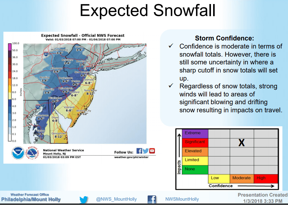
This is a brief Wednesday midday update on the Thursday snow. So far everything looks on track. As seen above the NWS has increased their snow forecast for 2-4″ of snow for western New Jersey from west to east. I think that’s a good forecast at this point.
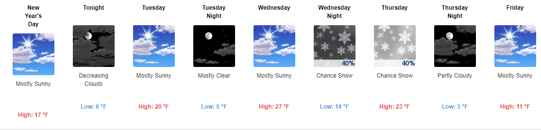
The snow should start after midnight but before sunrise. The heaviest part should be from about 6 am until noon. Then just flurries and turning windy with some strong wind gusts in the afternoon!
Then bitter, bitter cold air and wind into Sunday morning with near or slightly below zero temperatures Saturday and Sunday mornings.

NWS Winter Storm Severity Index
In case I didn’t make this clear earlier, this is going to be a powerful storm. The big question is how far west will it’s impact be. For locations along the coast and New England, this will have a major impact with not only snow, but wind, tides and cold.
Computer models so far today have trended the storm to be more west that previous. If this trend continues, we will have more impact to western New Jersey and I’ll need to adjust the forecast accordingly.
These ocean storms always have a tendency to impact inland more than the computer models indicate. That is why I’m forecasting 1-3″ at the moment which is more than the NWS has forecast at the moment. Right now the “worse case” amount of snow for us around 6″ with a foot or more near the coast. If the storm tracks further to the west these numbers will go up.
Again Thursday is the day for this storm.
Bitter Cold and Wind After The Storm
I also want to highlight that no matter how much snow we get from this storm, it will be very windy later Thursday, Friday and even Saturday somewhat. Besides the wind it WILL GET EVEN COLDER THAN IT IS NOW. We could very well co below zero for low temperatures Saturday and Sunday morning.
The only good news for warmer weather fans is it looks to turn warmer next week and hopefully we should get closer to normal which is highs in the mid 30’s!

NWS Snow forecast for Thursday
Another cold and windy day in western new jersey. Stewartsville morning low temperature of 9 as the kids return to school after winter break. Today will be a few degrees warmer than yesterday and Wednesday looks to be another few degrees warmer with less wind.
Then our attention turns to the storm for Thursday. There is no doubt that a major coastal storm will form and move up the east coast. The question is how close does it get to us. Eastern new england will get hit hard with this storm. I do believe it will snow in western New Jersey and my forecast at the moment is for 1-3″ with more south and east and less north and especially west. I will continue to track this storm and provide updates.

Happy New Year
Hope everyone had a safe and Happy New Year! The morning low temperature in Stewartsville was 2.9 degrees. It was 7 at midnight for anyone festive enough to venture outside!

NWS Snow forecast for Thursday
As we return to our regular schedules after the holiday break, besides dealing with the continued cold this week we need to keep our attention on the potential for some snow late Wednesday into Thursday. Right now the majority of the storm looks to stay off shore to our east. But some computer models have western New Jersey brushed with a little bit of snow. You can see the current National Weather Service (NWS) thinking on the storm of which I agree with.
Going forward we need to keep an eye on the computer models and look for any westward trends.
7 Day Forecast
Then even colder air arrives late week. Look at that high temperature forecast for Friday! Brrrrr! There looks to be a little light at the end of the proverbial tunnel. Not only is the amount of daylight we are receiving each day increasing slowly, our current 8-14 day outlook has normal temperatures returning to our area. Of course if we had high temperatures in the upper 30’s today with no wind everyone would be outside with tee-shirts on!

1″ of snow in Stewartsville, NJ on December 30, 2018
We’re back in the freezer after some light snowfall on Saturday. High temperatures today should be in the mid to upper teens.
Happy New Year
Anyone venturing into New York City to see the ball drop will be experiencing the second coldest NYE on record. Even if you are not going into the city today it will be very cold and breezy so bundle up and be safe!
We may “warm up” to the upper 20’s mid week then all eyes turn to a storm that will be mostly staying off shore as it looks right now. Will it trend further to the west and impact us Thursday? We’ll keep an eye on it.
Once that storm passes, it looks to usher in EVEN COLDER AIR that what we’ve experienced so far this winter!

Radar at 7:30 am
As you wake up this Saturday morning you will find light snow falling in western New Jersey with temperatures in the mid teens.

NWS Snow forecast
As seen in the radar above, the heaviest bands of snow appear to be setting up to our south. As a result those locations could see up to 3″ of snow. The rest of the area should see up to 2″ of light snow.

The NWS has issued a winter weather advisory for areas to our south.
The light snow should let up by early afternoon. Then we should see some flurries or perhaps some snow showers this afternoon. Then more bitter cold air returns after our “balmy” day today…

NWS forecast for snow on Saturday
Still cold out but at least the wind is not as strong. As of right now we’re at the high temperature for yesterday and it’s only 1:30 pm so hopefully we’ll get in the low to mid 20’s.
Periods of light snow should arrive just after daybreak on Saturday and move in from SW to NE. I still believe we are going to receive a coasting to 2″ overall in western New Jersey. Recent computer guidance is suggesting the “heaviest” band will be from NW to SE across western NJ.
Something to keep in mind is it will be in the mid to upper 20’s tomorrow during the snow so our snow ratio will be higher. This will make the snow lighter and fluffier. Usually snow like that accumulates more (but also compacts down more too)
Recent Comments