31. December 2018 · Comments Off on 2018 Ends On A Wet Note · Categories: winter · Tags: , , ,
Last sunrise of 2018 with high clouds rapidly increasing

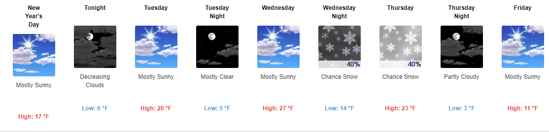
Early morning sunshine is rapidly fading away behind increasing clouds. Rain from our next system should be in our area by mid-day.

NWS rain forecast

Our area looks to receive an additional 3/4″ – 1.25″ of rain this afternoon, evening into the early morning of January 1, 2019. This rain has already made for a top 5 in precipitation for 2018 for many locations in our area. Reading, PA is the wettest ever; Allentown top 3.

7 Day NWS forecast

After this afternoon’s rain, we should see a mild day to start off 2019 but winds will pick up and become gusty in the afternoon. If you plan on enjoying the unseasonable warmth please do so in the morning if possible.

Cooler air returns for the balance of the week but it will be slightly above normal. More rain looks to return on Friday.

Happy New Year everyone!

01. January 2018 · Comments Off on 2018 Continues The Cold! · Categories: winter · Tags: ,

Happy New Year

Happy New Year

Hope everyone had a safe and Happy New Year! The morning low temperature in Stewartsville was 2.9 degrees. It was 7 at midnight for anyone festive enough to venture outside!

NWS Snow forecast for Thursday

NWS Snow forecast for Thursday

As we return to our regular schedules after the holiday break, besides dealing with the continued cold this week we need to keep our attention on the potential for some snow late Wednesday into Thursday. Right now the majority of the storm looks to stay off shore to our east. But some computer models have western New Jersey brushed with a little bit of snow. You can see the current National Weather Service (NWS) thinking on the storm of which I agree with.

Going forward we need to keep an eye on the computer models and look for any westward trends.

7 Day Forecast

7 Day Forecast

Then even colder air arrives late week. Look at that high temperature forecast for Friday! Brrrrr! There looks to be a little light at the end of the proverbial tunnel. Not only is the amount of daylight we are receiving each day increasing slowly, our current 8-14 day outlook has normal temperatures returning to our area. Of course if we had high temperatures in the upper 30’s today with no wind everyone would be outside with tee-shirts on!

31. December 2017 · Comments Off on Coldest New Year’s Eve In Decades · Categories: snow, winter · Tags:

1" of snow in Stewartsville, NJ on December 30, 2018

1″ of snow in Stewartsville, NJ on December 30, 2018

We’re back in the freezer after some light snowfall on Saturday. High temperatures today should be in the mid to upper teens.

Happy New Year

Happy New Year

Anyone venturing into New York City to see the ball drop will be experiencing the second coldest NYE on record. Even if you are not going into the city today it will be very cold and breezy so bundle up and be safe!

We may “warm up” to the upper 20’s mid week then all eyes turn to a storm that will be mostly staying off shore as it looks right now. Will it trend further to the west and impact us Thursday? We’ll keep an eye on it.

Once that storm passes, it looks to usher in EVEN COLDER AIR that what we’ve experienced so far this winter!

01. January 2016 · Comments Off on Cold Weather on the way · Categories: winter · Tags: , ,

886393_761734167295446_1681820138355773437_o

First off Happy New Year to all faithful blog readers! As you can feel in the air today, the new year and new month has brought a change in the weather. The above normal pattern appears to have finally changed. In fact while temperatures the next few days will be closer to normal for early January, they will feel much colder to us since we’re used to warmer weather.

And more is on the way for western New Jersey. Some of the coldest air of the young season will be moving into our area Monday into Tuesday. Both of those days will barely get above freezing and morning lows can be in the upper single digits or low teens’s.

Yes is is January and this type of weather isn’t all that unusual. We’ve all been spoiled by the warm start to winter. There were even a few snow flurries in sports today. As you can see in the above map there’s more to our west. The Lake Effect snow machine is on and will be giving the usual places snow.

With colder air in place we need to start watching for moisture and see if the two can coincide. There are some signs of traditional winter weather so stay tuned! And Happy New Year!

31. December 2014 · Comments Off on Year In Review: 2014 · Categories: weather discussion · Tags:

The year may not quite be over yet but I think its OK to look back at the weather of 2014 from a high level graphical point of view:

2014-2

Extremes above show a high of 91 and a low of –3. 39” of rain. All of these weather stats were recorded on my Davis VantageVUE (rooftop) and recorded and displayed via WUnderground. As such, since the rain gauge is not heated, frozen precip will be missing so the actual precip is higher.

2014-1

I love looking at the year in a line chart above. It shows nice correlation on some of the data. For instance the high wind gust in January occurred at the same time as the low pressure on the same day.

Looking ahead today, New Years Eve, will be similar to yesterday. Partly cloudy, a light breeze and chilly with highs only reaching around freezing. Tonight if you are planning on being outside at all around midnight expect temperatures in the lower 20’s so bundle up!

Similar weather on Friday and increasing clouds on Saturday with a cold rain later in the afternoon into the evening. There could be some sleet mixed in at the beginning in the normally colder sections to the north and west. Sunday could see some shower chances. Colder weather returns as we all head back to work and school.

Happy New Year!

Customized Social Media Icons from Acurax Digital Marketing Agency
Visit Us On TwitterVisit Us On FacebookVisit Us On PinterestVisit Us On YoutubeVisit Us On Instagram