
Sussex-Warren-Berks-Lehigh-Northampton-
Including the cities of Newton, Washington, Reading, Allentown,
Bethlehem, and Easton
348 PM EST Thu Jan 11 2018

...WINTER WEATHER ADVISORY IN EFFECT FROM 4 AM TO 10 AM EST
SATURDAY...

* WHAT...Freezing rain expected and maybe a little sleet. The ice
  will result in difficult travel conditions. Total ice
  accumulations of up to one tenth of an inch are expected.

* WHERE...Portions of northwest New Jersey and east central
  Pennsylvania.

* WHEN...From 4 AM to 10 AM EST Saturday.

* ADDITIONAL DETAILS...temperatures will fall sharply near 50 at
  midnight to around 30 at 7 am Saturday with icing developing
  rapidly toward daybreak Saturday on gusty north to northwest
  winds.


PRECAUTIONARY/PREPAREDNESS ACTIONS...

A Winter Weather Advisory means that periods of freezing rain
will cause travel difficulties. Be prepared for slippery roads.
Slow down and use caution while driving. The latest road
conditions for the state you are calling from can be obtained by
calling 5 1 1.

Ice forecast for Saturday morning
If the cold air arrives fast enough Saturday morning there could be some freezing rain and sleet in northern areas as seen in the map above.

5 Day Forecast
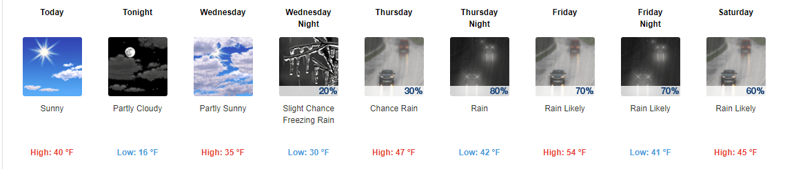
Western New Jersey will have another day with temperatures above normal with highs in the 40’s. Clouds will prevail be the rain should hold off until after midnight.
Friday will feature periods of rain that will last until early Saturday morning. We should receive 1-2″ of much needed rain. Then sharply colder air arrives on Saturday morning. There’s a slight chance some of the rain could end as a wintry mix. If this happens it will be in the morning. I’ll keep an eye on it and let you know if I see this happening.
Then back in the ice box for several days. Fear not it won’t be as long or severe as last time but it will make you remember that it’s still January

NWS 5 Day Forecast
Yesterday was a much needed break in the cold with high temperatures approaching the mid 40’s in many locations. A high of 44 in Stewartsville. While running some errands around mid day I caught myself walking into a store with my coat not even zipped up!
Today will feature increasing clouds ahead of our next system. High temperatures should be close to normal with mid to upper 30’s expected. Tonight will not be as cold as this morning. Thursday will be a cloudy day with rain arriving later in the day. The rain should continue off and on into Saturday morning. The positive sides are we need the rain and Friday should be very warm with high temperatures approaching near 60 degrees! We should also get at least 1″ of rain over the 2 day stretch. Again this is much needed rain let’s just hope it doesn’t cause too much flooding from melting snow.
Don’t put away the winter clothes just yet. We will turn sharply colder Saturday afternoon and evening and that will continue into early next week. But the cold will not be as harsh as the last outbreak nor as windy but it will remind us it still is January.
Long range later next week looks to moderate a little back to normal. There may be a fast moving clipper system Tuesday/Wednesday of next week which could give us some light snow.

Cold spell from 12/15/17 – 1/9/18
Western New Jersey received a wintry mix of precipitation on Monday as forecast. The precipitation started out as some freezing rain and sleet and eventually transitioned to some light snow that amounted to a coasting to 1″. Stewartsville received 0.4″ of new snow.
High temperatures in western New Jersey have remained below freezing since Christmas! Today will be the first day since then we will make it above the 32 degree mark! It may even feel balmy outside!
If it doesn’t feel balmy today it certainly will on Friday with high temperatures are forecast to be in the 50’s. The warmth will be accompanied by some rain. It will turn sharply colder for the second half of the weekend into early next week but it won’t be as severe as the last cold outbreak and will not last as long.

Sleet and freezing rain on the radar
Even though its been so cold for the last 2 weeks, warmer air has worked into the air above the ground changing the snow to sleet and freezing rain as seen in the pink on the above radar.
So prepare yourself for more mixed precipitation than snow this afternoon

Light snow approaching Eastern PA
Western New Jersey is still on track to see this just after lunch or about 1-3 pm start. Some sleet and freezing rain can be mixed in as well.

Winter weather advisory for Hunterdon County
409 AM EST Mon Jan 8 2018

...A WINTRY MIX IS EXPECTED THIS AFTERNOON AND EVENING...
409 AM EST Mon Jan 8 2018

...WINTER WEATHER ADVISORY REMAINS IN EFFECT FROM 1 PM THIS
AFTERNOON TO 9 PM EST THIS EVENING...

* WHAT...Freezing rain, sleet and snow expected. The ice will
  result in very slippery conditions on untreated sidewalks, roads
  and bridges. Total ice accumulations of a light glaze are
  expected, with snow and sleet accumulations of up to one half
  inch.

* WHERE...Much of eastern Pennsylvania, central and southwestern
  New Jersey, northern Delaware and far northeastern Maryland.

* WHEN...This afternoon through much of this evening.

* ADDITIONAL DETAILS...Ice will likely create hazardous conditions
  on area roads and walkways as the ground is very cold. The icy
  conditions could result in significant travel delays for the
  evening commute.

PRECAUTIONARY/PREPAREDNESS ACTIONS...

A Winter Weather Advisory means that periods of freezing rain,
sleet and snow will cause travel difficulties. Be prepared for
slippery roads. Slow down and use caution while driving. The
latest road conditions for the state you are calling from can be
obtained by calling 5 1 1.

NWS Ice Forecast

NWS Snow Forecast
Western New Jersey should see some light snow this afternoon starting from 1-3 pm. Most of this should be light snow but near the end and in southern locations it could mix with or change so sleet and freezing rain. The above is an ice forecast followed by a snow forecast from the NWS. My forecast is still for a coasting to 1″. Wintry mix should be over by early evening.

Sunday morning lows below zero!
Cold cold Sunday morning! -2 in Stewartsville and as you can see below zero in many other locations in western New Jersey.

NWS Snow forecast for Monday
With less wind on Sunday it will feel warmer but the air temperature will still be in the teens to around 20. With the warmer air comes the chance for some light precipitation Monday afternoon. Look for some light snow and even sleet to move into the area by mid afternoon Monday. Expect a coasting to 1″
Recent Comments