13. January 2020 · Comments Off on Early Thoughts On Weekend Storm · Categories: weather discussion, winter · Tags:

Gone is the weekend warmth. Believe it or not, today is still above normal temperature-wise by mid-January standards.

Computer models today continued the trend of keeping a storm to impact our area late Friday night into Saturday. Today’s trends keep cold air in our area a little longer. It still looks like snow to mix to ultimately rain event but there could be enough snow on the front end to make it notable.

The above graphic show the probability of seeing over 0.25″ of liquid equivalent between Saturday morning and Sunday morning. If all of this fell as snow, this would roughly amount to 2-4″

We’ll continue to keep an eye on this as the weekend approaches.

12. January 2020 · Comments Off on Winter Is Coming, Back · Categories: weather discussion · Tags: ,

I hope everyone got outside yesterday and enjoyed the crazy unseasonably warm weather yesterday. I took advantage and rode 20 miles on my bicycle.

When we get unusual weather in the summer or winter the first thought that comes to my mind is we’re going to pay for this somehow. Don’t worry, winter is not over, In fact, there are continued signs of the pattern change back to reality will take place late week into the weekend.

So enjoy it while it lasts. Today is still warm but windy. This time next week we will be back to seasonable temperatures with temperatures in the 30’s.

09. January 2020 · Comments Off on Warm Weekend Ahead · Categories: weather discussion, winter · Tags: ,

This afternoon with some sunshine and thankfully no more strong winds itself makes it feel much more comfortable outside

And the trend will continue. Friday will feature high temperatures in the upper 40’s to near 50. Saturday near 60! The downside is there will be more clouds than sun, but warmth is warmth. If it’s not going to snow, let us all be comfortable at least and enjoy some outdoor activities.

Signs continue to suggest the pattern change will start the last week of the month. As of right now nothing overly cold, just more seasonal for starters.

07. January 2020 · Comments Off on Light Snow Moves In Later Today · Categories: weather discussion, winter · Tags: ,

Any early morning sunshine today will be replaced with increasing and thickening clouds. Light snow should break out in southern areas by mid to late afternoon. If the precipitation arrives early enough it could even fall as light rain initially.

As seen in the map above, most of the snowfall should be in southern locations primarily south of I-78. Snow should be over just after midnight and long gone by tomorrow’s AM rush.

Wednesday will be a blustery and chilly day as colder air gets blown into our area as the storm departs. There could even be a snow shower or two at times but nothing important. Thursday is the transition day before we start another impressive warm-up for the weekend.

29. December 2019 · Comments Off on End of Year Weather · Categories: weather discussion, winter · Tags:

A winter weather advisory is posted for far northern sections including Sussex County and the Poconos for some freezing rain.

This should be limited to areas far to the north as seen in the map above

Any early morning glimpses of brightness are gone and cloudy conditions will remain for the rest of today. An early look at radar shows our rain shield approaching the western New Jersey area. I was hoping the rain would hold off until mid-afternoon but I would not be surprised to see it arriving a little sooner, unfortunately.

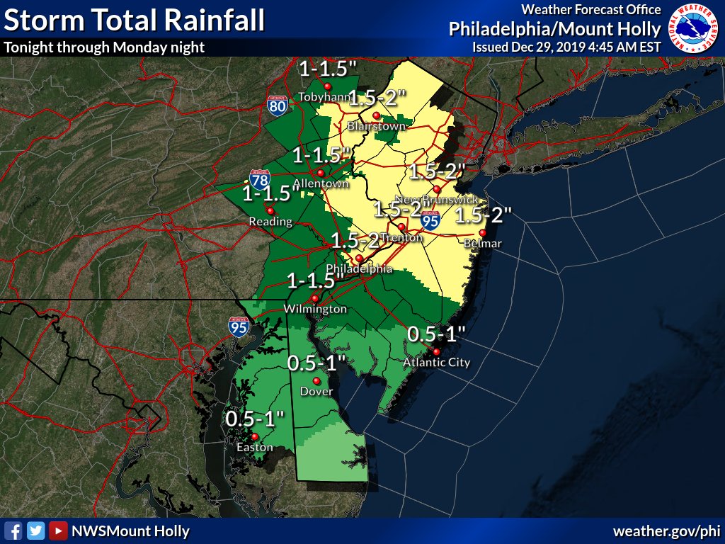
As seen in the map above the entire area should receive 3/4″ to 1.5″ of rain from later today through Monday. In fact, some showers could remain into Tuesday.

The rest of New Year’s Eve and New Year’s day looks OK but there will be a breeze but nothing too crazy.

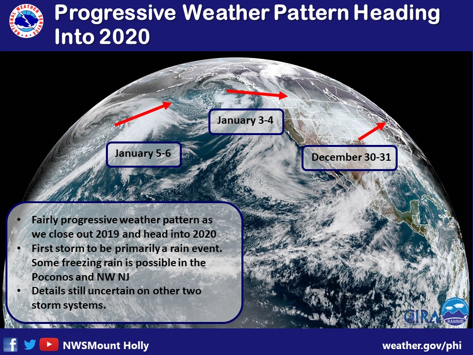
As far as January is concerned we look to be entering a more progressive pattern. Temperatures look to remain above normal into the first part of January

14. October 2019 · Comments Off on Weather This Week · Categories: Fall, weather discussion · Tags: ,

After a somewhat cloudy/foggy start early Monday morning, today will turn out to be a wonderful Columbus Day weatherwise. Mostly sunny skies and temperatures in the mid 70’s is nearly 10 degrees above normal for this time of year!

Tuesday will be very similar but a chillier start. Low temperatures Tuesday morning will be near 40. I’m sure some of the normally colder locations to the north and west could be in the upper 30’s. Afternoon temperatures will recover nicely but not be as warm as Monday with highs in the mid 60’s. We should start to see some increasing high clouds in the afternoon ahead of our next weather system.

Wednesday looks to be our next big weather system for the week. Rain showers should arrive on Wednesday morning and become heavy at times in the afternoon into the evening. Right now it looks like we could receive around 1″ of much-needed rain for western New Jersey.

Speaking of dry weather, the above map shows the latest drought monitor for New Jersey. All of western New Jersey remains in the abnormally dry, D0 rating. While not as bad as a few weeks ago, we are still on the dry side. Wednesday’s rain should be a big help as long as it doesn’t come down too fast and runoff.

End Of Week Into The Weekend

Once the Wednesday/Thursday morning storm moves away, it will usher down gusty winds and much colder temperatures. Thursday looks to be a blustery day with high temperatures not getting out of the 50’s. Friday should recover somewhat and we should get to near seasonable high temperatures. Right now we look to have another great weather-wise weekend with partly to mostly sunny skies and dry weather with seasonable temperatures.

11. September 2019 · Comments Off on Scattered Showers And Storms Possible Rest of Today · Categories: thunderstorms, weather discussion

Stewartsville has a high temperature so far of 89 today. Some sports have already reached 90.

The SPC has placed our area in a marginal risk for severe weather. It should be spotty.

Radar just after 4 pm shows some showers and thundershowers starting to develop in EPA – look for them to continue and expand a bit as they head to the east.

For areas that do receive some rain over the next 24 hours could receive 1/2 to 1″ of rain. It has been dry lately so a little rain would be nice.

05. September 2019 · Comments Off on Art and Weather · Categories: weather discussion

This looks very interesting. I may attend if my schedule permits.

Have a great day!
Gary

Gary Lessor
Assistant to the Director of Meteorological Studies and Weather Center
Meteorology Club Advisor
Meteorology Bridge Program Coordinator
Tri-State Weather Conference Organizer
Western Connecticut State University
181 White Street
Danbury, CT 06810
203 837 8552

02. September 2019 · Comments Off on Soggy Start to Labor Day · Categories: Hurricane, weather discussion · Tags: , ,

Happy Labor Day! Hopefully you were able to get outside yesterday or Saturday and enjoy some of the beautiful weather.

This morning and nice area of rain is moving into western New Jersey. It won’t last all day. This area will be done in a couple of hours. The rest of the day will have showers or perhaps even a thundershower.

Don’t be surprised if you hear a rumble of thunder today. There is a marginal risk of severe storms. I don’t expect any of those but there could be a little thunder this morning and perhaps later on today.

Major hurricane Dorian has slowed down to a crawl over the Bahamas. The forecast continues to show a move up the FL coast starting tomorrow. While the hurricane will hopefully stay offshore, intense coastal flooding along with heavy rain and winds will be felt along the eastern seaboard up to NC this week.

23. August 2019 · Comments Off on Heavy Rains Give Way To Cooler, Dryer Weekend · Categories: precipitation, weather discussion

Stewartsville and in fact all of south Warren county in western New Jersey joined in on the rain bandwagon last night. Stewartsville recorded 2.56″ in 24 hours ending at 7 am.

The front is past our area but light rain showers will persist until mid to late morning. From that point on it will get dryer and the sun should return with a refreshing north wind.

courtesy AccuWeather

Get ready for a fantastic late Summer weekend. You might even need a sweatshirt especially in the evenings. High temperatures will be in the 70’s and overnight lows in the 50’s. The A/C will get a much needed break along with your electric bills!

Customized Social Media Icons from Acurax Digital Marketing Agency
Visit Us On TwitterVisit Us On FacebookVisit Us On PinterestVisit Us On YoutubeVisit Us On Instagram