
https://www.useloom.com/share/f62670694faa4a398051067f74892242

High temperatures on Friday/early Saturday
Incredible warmth yesterday and a good amount of rain as well.

Stewartsville recorded 1.51″ of rain Friday/Saturday
Most areas of western New Jersey received 1.5-2″ of rain Friday/Saturday

5 day forecast
Their could be some scattered snow showers today but the big story will be the sharply colder temperatures and breezy conditions. It won’t be as bad as last time but stings just the same after the 60’s yesterday!
There are two chances for light snow next week. One on Tuesday and another potential one on Wednesday. I’ll keep an eye on both but for now find the winter clothing and put it back on!

Radar showing another area of rain to move into western New Jersey
Just about 1″ of rain has fallen in Stewartsville so far today. As seen in the radar image above another area of rain is about to move into western New Jersey. This should be somewhat lighter than what we received before.
Look to the far left on that map and you see pink and blue representing mixed precipitation and snow. Yes that’s right while it’s in the low 60’s here, it’s snowing in the far NW part of PA.

NWS Ice Forecast for Saturday AM
Th cold air should arrive in western New Jersey very fast between 1 am and 5 am tomorrow morning. If it’s still raining we could see that change over to some sleet or freezing rain. As such the NWS has issued a winter weather advisory for Warren county and further N&W. The threat should be over by mid morning tomorrow then sharply colder temperatures over the weekend into next week.
Next change of some wintry weather will be on Tuesday and Wednesday. More on that as it approaches.

5 Day Forecast
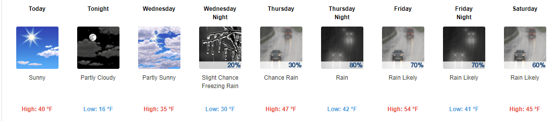
Western New Jersey will have another day with temperatures above normal with highs in the 40’s. Clouds will prevail be the rain should hold off until after midnight.
Friday will feature periods of rain that will last until early Saturday morning. We should receive 1-2″ of much needed rain. Then sharply colder air arrives on Saturday morning. There’s a slight chance some of the rain could end as a wintry mix. If this happens it will be in the morning. I’ll keep an eye on it and let you know if I see this happening.
Then back in the ice box for several days. Fear not it won’t be as long or severe as last time but it will make you remember that it’s still January

NWS 5 Day Forecast
Yesterday was a much needed break in the cold with high temperatures approaching the mid 40’s in many locations. A high of 44 in Stewartsville. While running some errands around mid day I caught myself walking into a store with my coat not even zipped up!
Today will feature increasing clouds ahead of our next system. High temperatures should be close to normal with mid to upper 30’s expected. Tonight will not be as cold as this morning. Thursday will be a cloudy day with rain arriving later in the day. The rain should continue off and on into Saturday morning. The positive sides are we need the rain and Friday should be very warm with high temperatures approaching near 60 degrees! We should also get at least 1″ of rain over the 2 day stretch. Again this is much needed rain let’s just hope it doesn’t cause too much flooding from melting snow.
Don’t put away the winter clothes just yet. We will turn sharply colder Saturday afternoon and evening and that will continue into early next week. But the cold will not be as harsh as the last outbreak nor as windy but it will remind us it still is January.
Long range later next week looks to moderate a little back to normal. There may be a fast moving clipper system Tuesday/Wednesday of next week which could give us some light snow.

Cold spell from 12/15/17 – 1/9/18
Western New Jersey received a wintry mix of precipitation on Monday as forecast. The precipitation started out as some freezing rain and sleet and eventually transitioned to some light snow that amounted to a coasting to 1″. Stewartsville received 0.4″ of new snow.
High temperatures in western New Jersey have remained below freezing since Christmas! Today will be the first day since then we will make it above the 32 degree mark! It may even feel balmy outside!
If it doesn’t feel balmy today it certainly will on Friday with high temperatures are forecast to be in the 50’s. The warmth will be accompanied by some rain. It will turn sharply colder for the second half of the weekend into early next week but it won’t be as severe as the last cold outbreak and will not last as long.

Radar shows lighter snow bands in western sections of western New Jersey

Well that was fun. I realized a while ago that “something” happened preventing me from logging onto this website/blog. But I never had the time to troubleshoot it. I finally had the time today not that the holidays are almost over. Funny thing is I started chatting with tech support on how to fix it and while I was waiting on them, I figured out how to fix it!
So that brings me to an important point. My website was up – I just could make any updates. Sooooooo if that happens again, or if you notice there haven’t been any updates in a while PLEASE go to my Facebook page the accompanies this at:
https://www.facebook.com/westernjerseywx/

Lightening strikes in Stewartsville July 21, 2017. Photo by DAVE DABOUR

The storms didn’t disappoint yesterday late afternoon/early evening. There was plenty of lightening to see and rain. Stewartsville received 0.76″ of rain from the severe thunderstorm.
First off Happy Fathers Day to all the Dad’s out there! I’m proud to be part of that group and have two great daughters!

Sunday severe weather threat for western new jersey
Weather wise today will feature more of the same of hot and humid weather with some scattered showers and thunderstorms. The heaviest and strongest storms today will stay west of western new jersey.

Monday severe weather threat for western new jersey
Tomorrow, Monday looks more interesting for severe weather. The atmosphere will be more favorable tomorrow for severe thunderstorms. This doesn’t mean they will happen – just more favorable.
The timeline today could be any part of the day. For Monday the most interesting part of the day looks to be 12-6 pm.
I’ll post more as the situation changes.
Recent Comments