18. December 2018 · Comments Off on More Heavy Rain Thursday Night Into Friday · Categories: Fall, flood watch
NWS forecast of up to 2″ rain Friday

The last thing our region needs is more rain. What I found amazing is we had a stretch of 9 days or so of no measurable rain. Then we receive an additional 1.5″ of rain and the ground is flooded just as much as it was 9 days prior. I think part of the problem is the ground was frozen so the moisture had no place to go.

Unfortunately we are going to have another windy rainy storm later Thursday into Friday. I expect this storm to be another over-producer. Right now the models are forecasting 1.5 – 2″ of new rain. I would prepare for at least 2″ of new rain if not more. And it could turn windy as well. There could be some flooding of streams and rivers. 

This is the last thing we need just before the holidays. I’ll provide more updates as they become available.

25. November 2018 · Comments Off on Impressive Rain Totals Overnight Saturday · Categories: Fall, flood watch · Tags:

Rain totals from overnight

There’s an old saying “when it rains, it pours” and that was certainly true last night. Another round of impressive overproducing rainfall that we don’t need in western New Jersey. 2.32″ was recorded in Stewartsville. Look at the map above to see some other reports.

How much did you record?

Sunday is a very pleasant day we all desperately need to not only dry out but to do any needed outdoor activities. Holiday lights might be a good idea!

More rain returns for Monday afternoon. Right now it “only” looks like another 1/2 to 3/4 of an inch. Cooler weather returns for the balance of the week after the rain

Areal flood watches remain in effect for certain streams

19. November 2018 · Comments Off on Light Rain and Snow Tonight and Tuesday · Categories: Fall, weather discussion · Tags: , ,

NWS snow forecast

A system to our north will be giving us some light rain chances today and tomorrow. Further to the north, closer to I-80 and above, there could be some slushy snow accumulations. Nothing like last time…

7 Day forecast

After that get ready for some cold turkey. Thanksgiving day (and morning and Black Friday morning) looks very cold, especially for this time of year. Luckily the cold won’t last too long…

16. November 2018 · Comments Off on Early Season Snowstorm Pulls Away · Categories: Fall, snow · Tags: ,

7.7″ of snow in Stewartsville NJ

To say yesterday’s snowstorm was an over-producer is an understatement. When you melt all the snow and sleet and freezing rain it totaled 1.67″ in Stewartsville. As you may recall in an earlier post only 1-1.25″ was forecast. So if this was all snow, we would have been clobbered even more.

The cold air hung on much longer than anticipated. And the snowfall rates were 2″ per hour for a time yesterday afternoon! We don’t see snowfall rates that impressives until the middle of winter!

The roads are a mess and many schools are closed. Today’s high temperature is already above freezing and should get into the low 40’s. Hopefully some good melting will take place but remember the ground is already saturated from all the recent rains. We should see sunshine today but the winds will pick up as the storm pulls away.

Good news is the weather look quiet into Thanksgiving week but it will remain on the cool side.

15. November 2018 · Comments Off on Early Winter Storm Update · Categories: Fall, snow, weather discussion · Tags:

The overnight temperature didn’t drop as much as I expected. The early arrival of clouds was responsible for that. Right now we are around 30 degrees in southern warren county. Other locations are in the mid to upper 20’s to the north.

Temperatures 8 am Thursday morning

Many school districts have early dismissals today.

Radar 8:30 am

The radar show the approach of the wintry precipitation. Take note that the light snow just to our SW is not yet reaching the ground. This is common in the winter time when the atmosphere is cold and dry before a storm. It takes a little bit for it to moisten up enough for the precipitation to reach the ground.

Once the snow changes to rain, we expect the total liquid from this storm to be over 1″ and possibly even 1.5″ in some spots. So a lot of the frozen precipitation on the ground will get washed away in some spots

Timing: Look for snow to arrive in western New Jersey between 10 am and 1 pm from SW to NE. Don’t be surprised to see the snow go to sleet after it starts and then back to snow. This is due to the warmer temperatures before the snow. ONce the snow starts it will cool off the temperature.

Sleet will start mixing in and even change over starting as early as 4pm to around 7 pm.

Rain will start mixing in and then changeover around dinner time in the southern areas to 10 pm further north
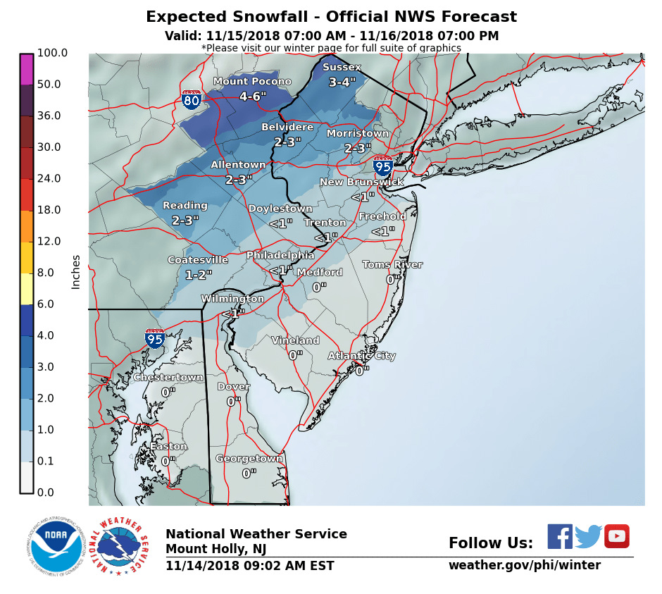
NWS snow forecast

How Much: The NWS has maintained their snow forecast of 2-3″ for most of western New Jersey with a bit more further north. My thinking is the sleet will arrive sooner and keep totals down to a coating to 2″ with more to the north.

Don’t be surprised if the rain ends as some wet snow early Friday morning as colder air comes in behind the departing storm. Quieter weather is expected for the next several days

14. November 2018 · Comments Off on Thursday Wintry Update · Categories: Fall, snow · Tags: , ,

NWS snow forecast for Thursday

Many computer models and other sources of information used to make weather forecasts have trended colder for tomorrow’s storm. The high pressure system to the north that will develop today will be stronger than originally thought. As a result today we will not see temperatures go up that much from where there are now despite sunshine. Tonight will be the coldest night of the new cold season.

As a result I’m increasing my snow forecast for tomorrow to a coating to 2″ with more to the north. The snow will still mix with and change to sleet/freezing rain and then rain my Thursday evening. The devil is in the details as they say as to when this happens. Most of the time for for I-78 corridor this happens sooner than anticipated. I’m counting on that to happen again this time hence why my snow totals are lower than the NWS map above. But of course the potential is there to receive more.

06. November 2018 · Comments Off on Election Day Rain · Categories: Fall, weather discussion · Tags:

SPC severe weather risk for Tuesday

The threat for severe weather today has shifted further to the south. This is in part mostly due to the arrival of the precipitation around midday to early afternoon. There will not be much heating of the atmosphere since we’re starting off cloudy and drizzly in spots.

Radar as of 8:30 am

The last thing we need in western New Jersey is anymore rain. It’s knocking on the doorstep of our area. Look for the worse of it around mid day to early-mid afternoon. If you haven’t voted yet I recommend doing it ASAP or later on today or tonight.

Rain total forecast

Thankfully yesterday’s rainfall forecast came up short (for a change). Stewartsville only received 0.22″ of new rain. Today we could see p to 1/2″ of additional rain. Some of it may come down quickly as a line of heavier shower and possibly a thundershower is forecast to approach from 11- 3pm

05. November 2018 · Comments Off on Rainy Monday; More Severe Weather Tomorrow? · Categories: Fall, thunderstorms, weather discussion · Tags: ,

24 hour precipitation forecast

Another rainy day is in store for western New Jersey Monday. Expect about 3/4″ of new rain ending tomorrow morning.

Severe weather risk for Tuesday

Come tomorrow the rain won’t go away. In fact as a cold front approaches, we could have a repeat of severe weather for NOvember. The Storm Prediction Center has placed all of western New Jersey in a marginal risk for severe weather. Further to the SW you can see the yellow in the map above for an increased or slight risk of severe weather. We’ll keep an eye on this and keep you posted as best we can.

7 Day NWS forecast

15. October 2018 · Comments Off on Marginal Risk for Severe Weather Later Today · Categories: Fall, thunderstorms · Tags:

Marginal risk for severe weather later today

The Storms Prediction Center has place most of our area (especially eastern sections) in a marginal risk for some severe weather later on today. We will mostly just see a period of heavier rain with perhaps a rumble or two or thunder. The timing of this looks to be from 7 – 10 pm this evening. This will be along some colder air that will move into the area and bring out high temperatures tomorrow back to the 50’s.

There’s a good chance for the first front of the season either Thursday and/or Friday morning. So if you have any sensitive plants outside, you may want to start planning…

11. October 2018 · Comments Off on Last Day of Augtober Then Fall Weather Arrives! · Categories: Fall · Tags: ,

5 day NWS forecast

Today’s rainfall for western New Jersey is from the approaching cold front and not from the remnants of former hurricane Michael. We should see anywhere from 1/2″ to 1″ in our area. Further to the south and east, where they will see some additional rainfall from Michael, amounts could be over 2″

The big story for us is autumn like weather is not only going to arrive but STAY AROUND for a while! Many people don’t realize the normal high and low temperatures this time of year are the mid 60’s and mid 40’s. We will actually be near or BELOW that for the next several days.

I think its safe to put the summer clothing away until next year unless you have a warm weather vacation in the months ahead 🙂

Social Media Integration by Acurax Wordpress Developers
Visit Us On TwitterVisit Us On FacebookVisit Us On PinterestVisit Us On YoutubeVisit Us On Instagram