17. February 2018 · Comments Off on Winter Storm Warnings Issued · Categories: snow · Tags:

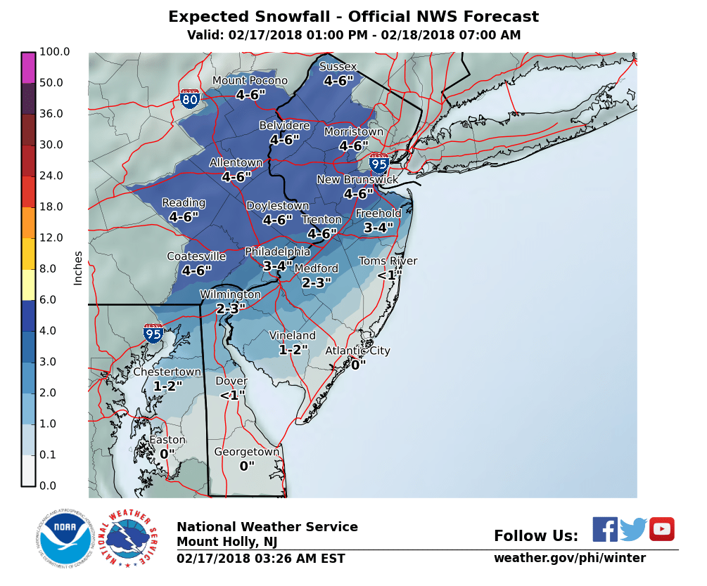
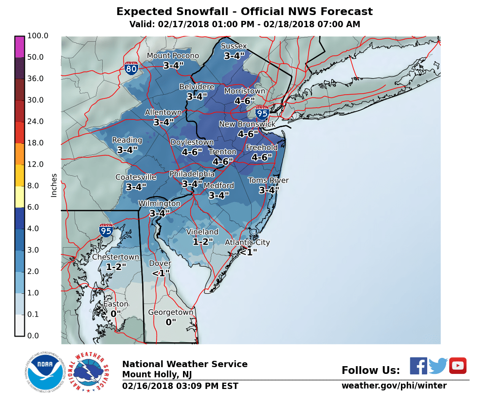
The NWS has upgraded the Winter Weather Advisory to Winter Storm Warning. Rightfully snow as much more snow is falling that was predicted

Sussex-Warren-Morris-Hunterdon-Somerset-Carbon-Monroe-Berks-
Lehigh-Northampton-Western Montgomery-Upper Bucks-
Including the cities of Newton, Washington, Morristown,
Flemington, Somerville, Jim Thorpe, Stroudsburg, Reading,
Allentown, Bethlehem, Easton, Collegeville, Pottstown, Chalfont,
and Perkasie
741 PM EST Sat Feb 17 2018

...WINTER STORM WARNING IN EFFECT UNTIL 4 AM EST SUNDAY...

* WHAT...Heavy snow. Total snow accumulations of around 6 inches
  are expected.

* WHERE...Portions of northern and northwest New Jersey and east
  central, northeast and southeast Pennsylvania.

* WHEN...Until 4 AM EST Sunday.

* ADDITIONAL DETAILS...Plan on difficult travel conditions. Be
  prepared for significant reductions in visibility at times. The
  snow may fall at 1 to 2 inches per hour at times in parts of the
  region, resulting in rapidly deteriorating road conditions.

PRECAUTIONARY/PREPAREDNESS ACTIONS...

A Winter Storm Warning for snow means severe winter weather
conditions will make travel very hazardous or impossible. If you
must travel, keep an extra flashlight, food and water in your
vehicle in case of an emergency. The latest road conditions for
the state you are calling from can be obtained by calling 5 1 1.
17. February 2018 · Comments Off on Snow Over Performing And Moving Fast · Categories: snow · Tags:

View out the window just before I got dark

I was amazed how fast the snow started coming down and how fast the temperature fell from the upper 30’s to around 32-33 degrees.

Radar as of 6:37 pm

Above is the radar showing all snow (blue) and plenty of it. The snow is moderate to heavy.

As of 6:30 pm 3″ of snow has already fallen in Stewartsville. I fear my forecast will bust on the low end. 3-6″ may have been a better forecast. The only hope for my forecast is the system is moving extremely fast. The heavy snow could be done by 10 pm!

17. February 2018 · Comments Off on Rain Mixed With Snow Initially Potential · Categories: weather discussion · Tags:

Beautiful late winter afternoon

Temperatures are in the upper 30’s and winds are out of the SE. This along with the beautiful weather outside makes it hard to believe it could be snowing in 5 hours!

Some short range computer models are suggesting that some rain could be mixed in at the beginning of the storm due to the warm temperatures and winds. Once the sun goes down and it gets colder, combined with heavier precipitation rates, should enable all snow as the evening progresses.

17. February 2018 · Comments Off on Snow Arrives Later Saturday Into Overnight · Categories: snow, winter · Tags:

NWS snow forecast

Sunny and cold Saturday morning will have increasing clouds as the day wears on. High temperatures will be in the mid to upper 30’s. Look for light snow to arrive as early as late afternoon and continue into the evening and night time hours.

My forecast remains at 2-4″ which is slightly lower than the NWS snow forecast pictured above. I think southern and eastern sections of western New Jersey will see some mixing of sleet and perhaps even rain at times especially towards the end of the storm. Temperatures will struggle to get to or below freezing tonight. This will result in a wet snow that will accumulate more on colder surfaces than treated surfaces. This will also be a very fast moving storm that could be done as early as just after midnight in western sections! There is a possibility I could be too low but I’m sticking with my gut for now.


17. February 2018 · Comments Off on Winter Weather Advisory · Categories: snow, winter · Tags:
902 AM EST Sat Feb 17 2018

NJZ001-007>010-012-015-PAZ054-055-060>062-101>106-172300-
/O.CON.KPHI.WW.Y.0008.180217T2100Z-180218T0900Z/
Sussex-Warren-Morris-Hunterdon-Somerset-Middlesex-Mercer-Carbon-
Monroe-Berks-Lehigh-Northampton-Western Chester-Eastern Chester-
Western Montgomery-Eastern Montgomery-Upper Bucks-Lower Bucks-
Including the cities of Newton, Washington, Morristown,
Flemington, Somerville, New Brunswick, Trenton, Jim Thorpe,
Stroudsburg, Reading, Allentown, Bethlehem, Easton, Honey Brook,
Oxford, West Chester, Kennett Square, Collegeville, Pottstown,
Norristown, Lansdale, Chalfont, Perkasie, Morrisville,
and Doylestown
902 AM EST Sat Feb 17 2018

...WINTER WEATHER ADVISORY REMAINS IN EFFECT FROM 4 PM THIS
AFTERNOON TO 4 AM EST SUNDAY...

* WHAT...Snow expected. Total snow accumulations of 3 to 5 inches
  are expected.

* WHERE...Most of eastern Pennsylvania and northern New Jersey.

* WHEN...Snow quickly overspreads the area from the southwest
  between around mid afternoon, becoming moderate to potentially
  heavy at times this evening. The snow should quickly by 4 AM.

* ADDITIONAL DETAILS...Plan on difficult travel conditions. Be
  prepared for reduced visibilities at times. The snow may fall at
  up to an inch per hour at times in parts of the region, which
  would result in rapid deteriorating road conditions.

PRECAUTIONARY/PREPAREDNESS ACTIONS...

A Winter Weather Advisory for snow means periods of snow will
cause primarily travel difficulties. Be prepared for snow covered
roads and limited visibilities, and use caution while driving. The
latest road conditions for the state you are calling from can be
obtained by calling 5 1 1.
16. February 2018 · Comments Off on Latest on Saturday Night Snow · Categories: snow · Tags:

NWS snow forecast for Saturday night

Computer models today have decreased and slightly shifted the snow axis to the east and south. Will continue to monitor to see if this is a trend or one off.

My forecast of 2-4″ still stands for overnight Saturday. Snow should start late afternoon/early evening and be over before sunrise Sunday. This will be a wet/heavy snow. Sunshine returns on Sunday with temperatures rising into the mid 40’s!

Winter Storm Watch still in effect for Saturday night. Look for this to go to either a warning or a Winter Weather advisory later today or early tomorrow morning.

16. February 2018 · Comments Off on Winter Storm Watch Saturday Night · Categories: snow, weather discussion, winter · Tags:

NWS Severity Index

The NWS has issued a winter storm watch for Saturday night. The map above is experimental and shows the potential impact from the next storm. For western New Jersey it’s a moderate impact.

NWS snow forecast

Above is the NWS snow forecast map. At this time my snow forecast remains the same: 2-4.” I still believe the computer models are showing too much precipitation for this fast moving storm. Plus there will be warm air not too far away and someone will be seeing mixed precipitation. Furthermore since it will be relatively warm the snow ratio will be low, perhaps not even 10:1 in southern and eastern areas.

Look for the snow to begin late afternoon and early evening Saturday and be mostly over before sunrise Sunday.

351 AM EST Fri Feb 16 2018

...WINTER STORM WATCH IN EFFECT FROM SATURDAY EVENING THROUGH
LATE SATURDAY NIGHT...

* WHAT...Heavy snow possible. Total snow accumulations of 4 to 6
  inches are possible.

* WHERE...The Lehigh Valley and Berks County, the southern Poconos
  and far northwestern New Jersey.

* WHEN...From Saturday evening into very early Sunday morning.

* ADDITIONAL DETAILS...Plan on difficult travel conditions.
  Significant reductions in visibility are possible. There remains
  some uncertainty with how much precipitation extends this far
  westward, however there is the potential for a short period of
  heavy snow Saturday night which could lead to a rapid
  deterioration in road conditions.

PRECAUTIONARY/PREPAREDNESS ACTIONS...

A Winter Storm Watch means there is potential for significant
snow, sleet or ice accumulations that may impact travel. Continue
to monitor the latest forecasts.
15. February 2018 · Comments Off on Beautiful Late Afternoon Thursday · Categories: snow, weather discussion, winter · Tags:

AccuWeather forecast Saturday Night

Simply gorgeous outside now with temperatures in the low 60’s! Get outside if you can!

Accuweather snow forecast

I’ll continue to monitor this forecast and update accordingly.

15. February 2018 · Comments Off on Early Look at Saturday Night Snow · Categories: snow, weather discussion, winter · Tags:

NWS snow forecast for Saturday night

Confidence has increased that there will be some accumulating snow Saturday night into early Sunday morning. The big questions now is how much. There’s a good chance of warmer air not being too far from western New Jersey – especially eastern and southern locations so that will have to be watched.

Early forecast based on what I’m seeing right now is 2-4″

Until then today will be quite mild. If we can get some sun out today after this fog burns off, we can easily get high temperatures in the upper 50’s to near 60 or better.

Rain will return tonight and last into Friday morning. Friday will then be a transition day starting off near 50 but dropping temperatures as the day goes on. Friday night will be quite chilly as will Saturday by recent standards. The snow should hold off until Saturday evening as it looks now.

14. February 2018 · Comments Off on Sneaky Snow Saturday? · Categories: snow, weather discussion, winter · Tags:

Storm threat late Saturday into Sunday

Keeping an eye on the potential for a sneaky fast moving snow threat for later Saturday into early Sunday morning. If the storm will be fast moving so if it does happen will not be the “big one.” It will be another nuisance snow if it happens. Saturday will be colder day compared to Friday – that is where the cold air will come from. If it does happen it should clear out for Sunday.

We’ll continue to keep an eye on this and keep you updated.

Plugin for Social Media by Acurax Wordpress Design Studio
Visit Us On TwitterVisit Us On FacebookVisit Us On PinterestVisit Us On YoutubeVisit Us On Instagram