12. February 2018 · Comments Off on Flurries Possible This Morning · Categories: weather discussion, winter · Tags:

Radar shows some light snow flurries moving in from the west

As colder air filters into western New Jersey this morning, some areas could see some light snow flurries. I don’t expect much if anything. After this passes we should hopefully see more sunshine later today.

Tonight the colder air will make its impact with low temperatures in the mid to upper teens. Shrove Tuesday will be a typical winter day with high temperatures in the mid to upper 30’s.

11. February 2018 · Comments Off on Sunday Soaker · Categories: precipitation, weather discussion · Tags:

Radar 8:30 am Sunday morning

About 3/4″ of rain has fallen so far in western New Jersey with more on the way. As seen in the radar composite above, all that rain to our SW is moving in our direction. Look for an additional 1-1.5″ of rain today lasting most of the day. The steady rain will become more periodic as the day wears on.

Temperatures are about 40 this morning but warmer air is not that far away. It will slowly push a little further north today. If it makes it to the southern sections of western New Jersey, look for temperatures to jump to near 50! I don’t think it will make it all the way up north.

Flood watch continues for Warren and Hunterdon counties

10. February 2018 · Comments Off on Flood Watch For Warren and Hunterdon · Categories: winter · Tags:

Flood watch for western New Jersey

National Weather Service Mount Holly NJ
320 AM EST Sat Feb 10 2018

DEZ001-002-MDZ008-012-015-019-020-NJZ007>010-012>027-PAZ060>062-
070-071-101>106-101800-
/O.NEW.KPHI.FA.A.0002.180210T2300Z-180212T0500Z/
/00000.0.ER.000000T0000Z.000000T0000Z.000000T0000Z.OO/
New Castle-Kent-Cecil-Kent MD-Queen Annes-Talbot-Caroline-Warren-
Morris-Hunterdon-Somerset-Middlesex-Western Monmouth-
Eastern Monmouth-Mercer-Salem-Gloucester-Camden-
Northwestern Burlington-Ocean-Cumberland-Atlantic-Cape May-
Atlantic Coastal Cape May-Coastal Atlantic-Coastal Ocean-
Southeastern Burlington-Berks-Lehigh-Northampton-Delaware-
Philadelphia-Western Chester-Eastern Chester-Western Montgomery-
Eastern Montgomery-Upper Bucks-Lower Bucks-
Including the cities of Wilmington, Dover, Elkton, Chestertown,
Centreville, Easton, Denton, Washington, Morristown, Flemington,
Somerville, New Brunswick, Freehold, Sandy Hook, Trenton,
Pennsville, Glassboro, Camden, Cherry Hill, Moorestown,
Mount Holly, Jackson, Millville, Hammonton, Cape May Court House,
Ocean City, Atlantic City, Long Beach Island,
Wharton State Forest, Reading, Allentown, Bethlehem, Media,
Philadelphia, Honey Brook, Oxford, West Chester, Kennett Square,
Collegeville, Pottstown, Norristown, Lansdale, Chalfont,
Perkasie, Morrisville, and Doylestown
320 AM EST Sat Feb 10 2018

...FLOOD WATCH IN EFFECT FROM THIS EVENING THROUGH SUNDAY
EVENING...

The National Weather Service in Mount Holly has issued a

* Flood Watch for portions of Delaware, northeast Maryland, New
  Jersey, and Pennsylvania, including the following areas, in
  Delaware, Kent and New Castle. In northeast Maryland,
  Caroline, Cecil, Kent MD, Queen Annes, and Talbot. In New
  Jersey, Atlantic, Atlantic Coastal Cape May, Camden, Cape May,
  Coastal Atlantic, Coastal Ocean, Cumberland, Eastern Monmouth,
  Gloucester, Hunterdon, Mercer, Middlesex, Morris, Northwestern
  Burlington, Ocean, Salem, Somerset, Southeastern Burlington,
  Warren, and Western Monmouth. In Pennsylvania, Berks,
  Delaware, Eastern Chester, Eastern Montgomery, Lehigh, Lower
  Bucks, Northampton, Philadelphia, Upper Bucks, Western
  Chester, and Western Montgomery.

* From this evening through Sunday evening

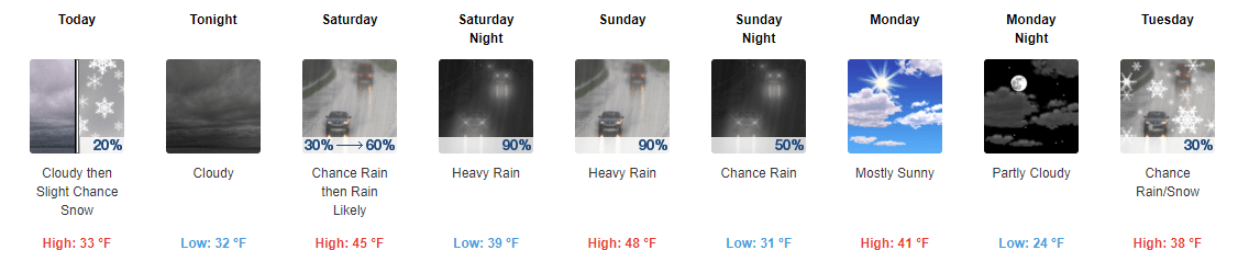
* Rain develops this afternoon, and then a prolonged period of
  heavy rain will overspread the region tonight through Sunday
  night. The axis of heaviest rain will fall along the I-95
  corridor, where between 2 and 3 inches of rain is expected to
  fall from northern Maryland and Delaware, through southeast
  Pennsylvania, and into most of New Jersey.

* Low-lying flooding is likely where the heaviest rain occurs. In
  addition, rainfall amounts may result in flooding on area
  streams, creeks, and rivers by late Sunday.

PRECAUTIONARY/PREPAREDNESS ACTIONS...

A Flood Watch means there is a potential for flooding based on
current forecasts.

You should monitor later forecasts and be alert for possible
Flood Warnings. Those living in areas prone to flooding should be
prepared to take action should flooding develop.
09. February 2018 · Comments Off on Weekend Weather Outlook · Categories: weather discussion, winter · Tags:

5 Day weather forecast

Chilly start Friday morning with temperatures in the upper teens to around 20. Today will be mostly cloudy with some flurries or even a period of light snow to the north. This could result in a coating up north.

Then let the warmth begin. Saturday will have high temperatures in the mid to upper 40’s repeated on Sunday. Unfortunately it will be rainy especially the second half. Hopefully the rain showers on Saturday will hold off until late afternoon. Then periods of rain Saturday night into Sunday. 1-2″ of rain is possible from this next system. Something to keep in mind is the ground is mostly still frozen. So if we do get a lot of rain there will not be many places for it to go except in storm drains. So there could be some low lying field flooding along with some fog in areas that still have some snow cover.

We still look to remain above normal temperatures into next week.

07. February 2018 · Comments Off on Long Range Weather Outlook: Rest of February · Categories: weather discussion · Tags:

6-10 day temperature outlook

Now that the first 7 days of February are done let’s take a longer look at the weather. After a cold night tonight  and chilly day tomorrow, we should enter a milder period the the next week. After that the above map shows we have a better than average chance for above normal temperatures for the 6-10 outlook

6-10 day precip outlook

For the same 6-10 day period of above normal temperatures looks to be an active period precipitation wise

8-14 day temp outlook

Looking a little bit further we still have a slightly above normal chance of warmer temperatures

8-14 day precip

And the 8-14 day period looks active to our north

Beyond that, for the rest of February into early March there are some questions. The bulk of the cold air over the north pole is forecast to split into two. One half is forecast to head south into the northern US. If this happens, it could not only provide cooler temperatures but setup an active storm track at the end of the month into early March. If it wasn’t for this potential, I would say we are close to being over the worse part of our winter season.

07. February 2018 · Comments Off on Freeze-up Tonight · Categories: winter · Tags:

After 1.3″ of snow fell in Stewartsville today, look for a sharp temperature drop later on tonight. It might be a good idea to remove any slush now or else it will be a bigger problem in the AM

Projected 10 pm temperatures

This computer model estimates most of western New Jersey will be below freezing at 10 pm and we should have an overnight low in the upper teens. The winds will pick up too.

07. February 2018 · Comments Off on Mostly Sleet in Southern Areas · Categories: Ice, winter · Tags:
Sleet moving into southern areas

Sleet moving into southern areas

As of 9:45 am mostly sleet is falling in Stewartsville. As seen in the map above this is approaching from the east and southwest. Let’s hope we stay more sleet than freezing rain. Freezing rain is falling in southern PA.

As of 9:45 1.3″ new snow in Stewartsville. This will probably be the total as little will accumulate further with the sleet then rain

07. February 2018 · Comments Off on Special Weather Statement · Categories: snow · Tags:
NJZ007>010-PAZ060>062-103-105-071600-
Warren-Morris-Hunterdon-Somerset-Berks-Lehigh-Northampton-
Western Montgomery-Upper Bucks-
Including the cities of Washington, Morristown, Flemington,
Somerville, Reading, Allentown, Bethlehem, Easton, Collegeville,
Pottstown, Chalfont, and Perkasie
840 AM EST Wed Feb 7 2018

...POOR TRAVEL CONDITIONS WITH A BRIEF BURST OF HEAVY SNOW
FOLLOWED BY A WINTRY MIX ACROSS THE I-78 CORRIDOR...

At 830 AM...Moderate to heavy snow has overspread the Interstate
78 corridor in central and northern New Jersey and in eastern
Pennsylvania. Snowfall rates of one inch per hour are possible in
spots during the mid morning before the snow changes to a mix of
sleet and freezing rain from south to north through 10 AM. Most of
the region should see a transition to all freezing rain between
10 and 11 AM.

Plan on poor travel conditions for the tail end of the morning
rush with poor visibility and with snow quickly accumulating on
roads in heavy snow. Icy conditions will follow into the late
morning after the changeover to sleet and freezing rain.
07. February 2018 · Comments Off on Moderate Snow Underway · Categories: snow · Tags:
Radar shows heavy snow in western New Jersey

Radar shows heavy snow in western New Jersey

Dark blues are moderate to heavy snow. Note the reds in southern Hunterdon county and points east. That is sleet and/or freezing rain. Freezing rain reported in Trenton already and Philly

07. February 2018 · Comments Off on Snow To Rain On Wednesday · Categories: snow, weather discussion, winter · Tags:
Snow overspreads into western New Jersey

Snow overspreads into western New Jersey

Snow has moved into western New Jersey as of early this Wednesday morning. Look for the snow to pick up in intensity at times. Notice the pink in the bottom of the radar map above along with the green out to the west. This is showing there is warmth moving north into this storm. I expect mixed precipitation to start in southern areas as early as late morning.

NWS snow forecast

NWS snow forecast

I’m still confident of my 1-3″ snow forecast for western New Jersey. There could be a little more further to the north and west where the changeover will occur later.

Updates throughout the day.

Plugin for Social Media by Acurax Wordpress Design Studio
Visit Us On TwitterVisit Us On FacebookVisit Us On PinterestVisit Us On YoutubeVisit Us On Instagram