05. September 2016 · Comments Off on Hermine And The Hot Week Ahead · Categories: Fall, Hurricane, Summer · Tags: ,

093741W_sm

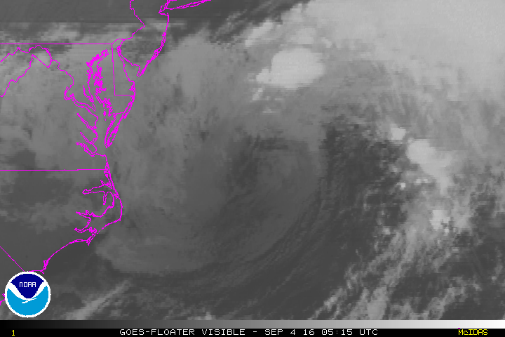
Here’s the Monday late morning update on Hermine. The storm is *finally* retrograding back to the west. But it is too far east to have any *significant* impacts to us here in western New Jersey. We will see more thin high clouds today than yesterday. There may even be more of a breeze than yesterday too. Expect high temperatures on Labor Day to be in the low 80’s. Overall great holiday weather.

Except if you at the shore. The shore will have more clouds today and it will be windy. You shouldn’t go into the warm water more than knee deep due to the rip current potential. And there will be continued beach erosion and some flooding at times of high tide. But it will be a nice enough day to get out and relax and visit shore vendors and enjoy the last day of the extended weekend.

7day

Hermine will take her time departing the area. In her wake will be a return to hot and humid weather. Just what we all wanted to see with school back in session. Expect high temperatures Tuesday-Friday in the upper 80’s the low 90’s on some days. We could start to see some scattered afternoon showers as early as Wednesday but the rain chances increase more as the week wears on. Keep in mind we are very dry and under drought conditions.

04. September 2016 · Comments Off on Hermine Sunday Morning Upgrade · Categories: Fall, Hurricane, Summer · Tags: ,

093741W_sm

At the beginning of Hermine’s landfall she was going further north and west that forecast. Yesterday she decided to stay further east and south. Perhaps it was the strong high pressure to the north. Regardless the storm is further offshore than forecast.

As you can see above, we are not completely off the hook. It is forecast to come back towards the coast a little but this will not be as close as originally thought. We will have no rain from this in western New Jersey. Today will be a partly sunny beautiful day. The Jersey shore will continue to see high waves, beach erosion and tital flooding at times of high tide.

If Hermine does turn back towards the coast, conditions will not be felt until later today in Monday.

vis-animated

03. September 2016 · Comments Off on Hermine Saturday Update · Categories: Hurricane · Tags: ,

093741W_sm

New since the last post: Hermine is forecast to become a hurricane again once it re-enters the warm waters of the Atlantic. This may not occur until later Monday into Tuesday. The storm will be very slow moving and may not be out of the area until Thursday.

At this time, we may not get very much rainfall from this system in western New Jersey. We may only see 1/2″ of rain. Some computer models don’t give us any rain. Winds will be gusty – even inland.

The most impact from this storm will be along the shore. Winds there will be much stronger and there will be coastal flooding, especially at times of high tide. There will be MANY high tide cycles with this storm since it will be around for so long!

Tropical storm warnings now up for the Jersey shore.

Today, Saturday will be a relatively nice day but we will see an increase in clouds from Hermine. We shouldn’t start to feel the impact of the storm until later Sunday.

02. September 2016 · Comments Off on Hermine Forecast To Stall · Categories: Hurricane · Tags: ,

093741W_sm

Latest forecast map from the National Hurricane Center. The forecast continues to take Hermine well to the east of us. If this track verifies, we would receive very little impact and rain from this storm in western New Jersey. Along the Jersey shore is a completely different story. It is very RARE to have a storm like this stall for several days. If it does, even if weakening, the winds and seas will continue to pound the shoreline communities causing beach erosion and possibly coastal flooding.

Same watches and warnings are posted along the eastern seaboard.

As expected, Hermine did weaken down to a tropical storm overnight. This is not unusual as a tropical system moves over land. But once it emerges over the mid Atlantic waters, these waters are unusually warm from our hot summer. Warm waters is what feed and strengthen ocean storms….

Rainfall Forecast from Hermine

Rainfall Forecast from Hermine

As of right now it doesn’t look like we will receive much rain from Hermine in western New Jersey. There will be some rain as you head further east. This doesn’t mean we will have sunny skies either. I expect more clouds than sun while our friend is in town.

01. September 2016 · Comments Off on Hermine Now A Hurricane · Categories: Hurricane · Tags: , ,

093741W_sm

Hermine is now a hurricane which is what was expected to happen.

Tropical storm warnings are now up for the east coast of FL up to NC/VA border area. Tropical storm watch is issued north of that up to near NYC which includes the New Jersey shore.

Guidance today has continued the idea of the hurricane remaining east of us when it gets this far north. The storm continues to look like it will slow down when it does get here. Look how little it moves from 1 pm Sunday to 1 pm Tuesday (last three S with circle around them. Keep in mind it probably will not be as strong then as it is now.

If the storm stays on this track, western New Jersey will see less rainfall. The shore continues to look like it will get the most impact from this including beach erosion.

01. September 2016 · Comments Off on Tropical Storm Hermine Overnight Update · Categories: Hurricane, Summer · Tags: , , ,
NHC Hermine Overnight Update

NHC Hermine Overnight Update

the overnight computer models along with the National Hurricane Center have adjusted the forecast path for Hermine back to the East. This is not surprising and we will continue to see the forecast models sway back and forth. The storm isn’t even on land yet. Once it is we will have better data to make hopefully better forecasts.

The important thing to keep in mind is the trend. For the last day or two the trend was to have the storm come further north and east. Now we see on 12 hour period that shits it further to the east. Let’s see if this continue or not.

What’s important to note, if the above track verify’s, even though its not as close as the previous track it will impact our weather with some wind and rain on Labor Day weekend.

Another important item to note is the steering currents for this storm get very weak as it gets near our area. Notice how the last two forecast locations on the map above have the circles very close to each other. There is a possibility the storm could stall or become erratic. Again, we need to keep an eye on it and see if the trend continues.

In other news Stewartsville pickup up about 1/3″ of much needed rain overnight. Look for scattered showers this morning giving way to nicer weather and a beautiful Friday!

Plugin for Social Media by Acurax Wordpress Design Studio
Visit Us On TwitterVisit Us On FacebookVisit Us On PinterestVisit Us On YoutubeVisit Us On Instagram