06. February 2017 · Comments Off on Freezing Rain Advisory Early Tuesday Morning · Categories: winter · Tags:

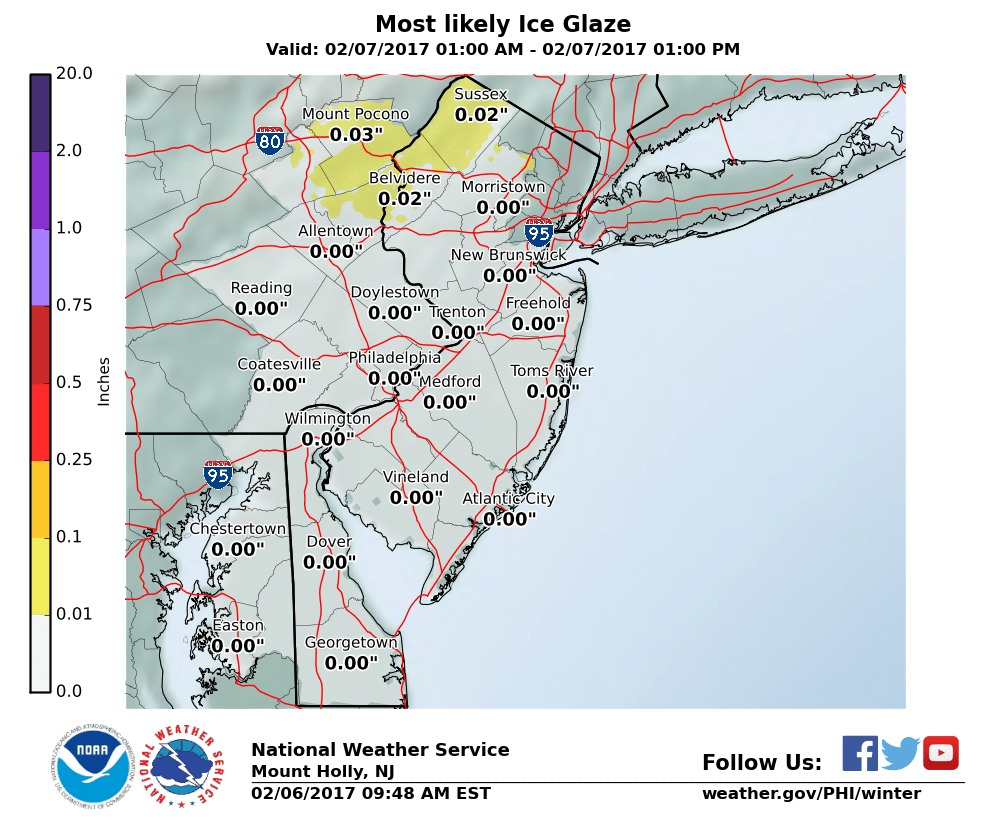
The NWS has issues a freezing rain advisory for Warren, Sussex and Northampton counties from 1 am to 10 am Tuesday. I do not expect this to be widespread and primarily a threat for northern areas.

SUSSEX-WARREN-CARBON-MONROE-NORTHAMPTON-
INCLUDING THE CITIES OF NEWTON, WASHINGTON, JIM THORPE,
STROUDSBURG, BETHLEHEM, AND EASTON
339 AM EST MON FEB 6 2017

...FREEZING RAIN ADVISORY IN EFFECT FROM 1 AM TO 10 AM EST
TUESDAY...

THE NATIONAL WEATHER SERVICE IN MOUNT HOLLY HAS ISSUED A FREEZING
RAIN ADVISORY, WHICH IS IN EFFECT FROM 1 AM TO 10 AM EST TUESDAY.

* LOCATIONS...THE SOUTHERN POCONOS, PORTIONS OF THE LEHIGH VALLEY
  AND FAR NORTHWESTERN NEW JERSEY.

* HAZARD TYPES...FREEZING RAIN.

* ICE ACCUMULATIONS...LESS THAN A TENTH OF AN INCH.

* TIMING...AREAS OF LIGHT FREEZING RAIN IS EXPECTED TO DEVELOP
  TOWARD DAYBREAK ON TUESDAY, THEN CHANGE TO PLAIN RAIN INTO
  TUESDAY AFTERNOON AS TEMPERATURES RISE.

* IMPACTS...LIGHT ICING MAY CREATE SLIPPERY CONDITIONS ON
  UNTREATED ROADS, ESPECIALLY ON BRIDGES AND OVERPASSES.

* TEMPERATURES...IN THE LOWER 30S, THEN RISING THROUGH THE 30S AND
  INTO THE 40S DURING THE MORNING AND AFTERNOON ON TUESDAY.

PRECAUTIONARY/PREPAREDNESS ACTIONS...

A FREEZING RAIN ADVISORY MEANS THAT PERIODS OF FREEZING RAIN OR
FREEZING DRIZZLE WILL CAUSE TRAVEL DIFFICULTIES. BE PREPARED FOR
SLIPPERY ROADS. SLOW DOWN AND USE CAUTION WHILE DRIVING.
26. December 2016 · Comments Off on Freezing Rain Advisory Until 11am · Categories: winter · Tags: , ,

The National Weather Service has issued a freezing rain advisory for this morning until 11 am for Warren county and further to the north. Hunterdon is not in the advisory area.

We are right around freezing and some very light rain is moving east from central PA this morning. This is response to some warmer weather that will arrive overnight into Tuesday. I do not expect this to be a big issue. If you are out and about when the rain starts, just be careful if the temperature is not yet above freezing. Then we turn more seasonable the rest of the week.

SUSSEX-WARREN-MORRIS-
INCLUDING THE CITIES OF...NEWTON...WASHINGTON...MORRISTOWN
340 AM EST MON DEC 26 2016

...FREEZING RAIN ADVISORY REMAINS IN EFFECT FROM 7 AM THIS MORNING TO 1 PM EST THIS AFTERNOON...

* LOCATIONS...FAR NORTHWESTERN NEW JERSEY.

* HAZARD TYPES...LIGHT FREEZING RAIN OR FREEZING DRIZZLE.

* ICE ACCUMULATIONS...A LIGHT GLAZE IS POSSIBLE.

* TIMING...AREAS OF FREEZING DRIZZLE OR LIGHT FREEZING RAIN SHOULD  DEVELOP THIS MORNING... THEN END BY EARLY AFTERNOON AS  TEMPERATURES
  SLOWLY RISE.

* IMPACTS...ICING MAY CREATE SLIPPERY CONDITIONS, ESPECIALLY ON  UNTREATED SURFACES.

* TEMPERATURES...IN THE LOWER 30S. TEMPERATURES RISING THROUGH THE  30S THIS AFTERNOON.

PRECAUTIONARY/PREPAREDNESS ACTIONS...

A FREEZING RAIN ADVISORY MEANS THAT PERIODS OF FREEZING RAIN OR FREEZING DRIZZLE WILL CAUSE TRAVEL DIFFICULTIES. BE PREPARED FOR
SLIPPERY ROADS. SLOW DOWN AND USE CAUTION WHILE DRIVING.


23. December 2016 · Comments Off on Freezing Rain Advisory Early Saturday Morning · Categories: weather discussion, weather forecast, winter · Tags: ,


Freezing Rain Advisory early Saturday morning

Freezing Rain Advisory early Saturday morning

The National Weather Service has issued a freezing rain advisory early Saturday morning. This is basically for the wee hours of Saturday morning starting from 1 am and should be well over by 9 am.

I don’t expect most areas in the south and central section of western New Jersey to see much if any freezing rain. In colder sections and deeper valley further to the north the rain may start out as a little freezing rain.

With many people traveling and visiting for the holidays it’s better to be safe than sorry.

We can expect rain to be over around mid day and for most areas of western New Jersey to receive about 1/4″ to 1/2″ of much needed rain. Of course no one wants to see rain on Christmas Eve but it should be well over before holiday services later in the day and evening.

Here is the advisory:

NJZ001-007>010-PAZ060>062-105-241100-
/O.NEW.KPHI.ZR.Y.0004.161224T0600Z-161224T1400Z/
SUSSEX-WARREN-MORRIS-HUNTERDON-SOMERSET-BERKS-LEHIGH-NORTHAMPTON-
UPPER BUCKS-
INCLUDING THE CITIES OF...NEWTON...WASHINGTON...MORRISTOWN...FLEMINGTON...SOMERVILLE...READING...ALLENTOWN...BETHLEHEM...
EASTON...CHALFONT...PERKASIE
315 PM EST FRI DEC 23 2016

...FREEZING RAIN ADVISORY IN EFFECT FROM 1 AM TO 9 AM EST SATURDAY...

THE NATIONAL WEATHER SERVICE IN MOUNT HOLLY HAS ISSUED A FREEZING RAIN ADVISORY...WHICH IS IN EFFECT FROM 1 AM TO 9 AM EST
SATURDAY.

* LOCATIONS...NORTHWEST NEW JERSEY AND PORTIONS OF EASTERN PENNSYLVANIA.

* HAZARD TYPES...FREEZING RAIN.

* ICE ACCUMULATIONS...LESS THAN ONE TENTH OF AN INCH.

* TIMING...LIGHT FREEZING RAIN MAY BEGIN AS EARLY AS 1 OR 2 AM, BECOMING HEAVIER BY 6 OR 7 AM. PRECIPITATION SHOULD CHANGE TO
  PLAIN RAIN EVERYWHERE BY 9 AM.

* IMPACTS...ICE ACCUMULATIONS MAY CREATE SLIPPERY ROAD CONDITIONS.

* TEMPERATURES...FALLING TO AROUND OR JUST BELOW FREEZING LATE THIS EVENING AND OVERNIGHT. TEMPERATURES EXPECTED TO RISE ABOVE
  FREEZING EVERYWHERE BY 9 AM.

PRECAUTIONARY/PREPAREDNESS ACTIONS...

A FREEZING RAIN ADVISORY MEANS THAT PERIODS OF FREEZING RAIN OR FREEZING DRIZZLE WILL CAUSE TRAVEL DIFFICULTIES. BE PREPARED FOR
SLIPPERY ROADS. SLOW DOWN AND USE CAUTION WHILE DRIVING.


26. January 2016 · Comments Off on Freezing Rain Advisory until 10 am · Categories: winter · Tags:

An area of light freezing rain has moved into eastern PA much early than anticipated. Temperatures are still well below normal now even though later today will get up to near 40 degrees. Be careful on untreated surfaces!

URGENT - WINTER WEATHER MESSAGE
NATIONAL WEATHER SERVICE MOUNT HOLLY NJ
747 AM EST TUE JAN 26 2016

...FREEZING RAIN ADVISORY...

DEZ001-MDZ008-NJZ007-009-PAZ070-071-101>106-261700-
/O.EXB.KPHI.ZR.Y.0001.000000T0000Z-160126T1700Z/
NEW CASTLE-CECIL-WARREN-HUNTERDON-DELAWARE-PHILADELPHIA-
WESTERN CHESTER-EASTERN CHESTER-WESTERN MONTGOMERY-
EASTERN MONTGOMERY-UPPER BUCKS-LOWER BUCKS-
INCLUDING THE CITIES OF...WILMINGTON...ELKTON...WASHINGTON...
FLEMINGTON...MEDIA...PHILADELPHIA...HONEY BROOK...OXFORD...
WEST CHESTER...KENNETT SQUARE...COLLEGEVILLE...POTTSTOWN...
NORRISTOWN...LANSDALE...CHALFONT...PERKASIE...MORRISVILLE...
DOYLESTOWN
747 AM EST TUE JAN 26 2016

...FREEZING RAIN ADVISORY IN EFFECT UNTIL NOON EST TODAY...

THE NATIONAL WEATHER SERVICE IN MOUNT HOLLY HAS ISSUED A FREEZING
RAIN ADVISORY...WHICH IS IN EFFECT UNTIL NOON EST TODAY.

* HAZARD TYPES...LIGHT FREEZING RAIN.

* ICE ACCUMULATIONS...TRACE AMOUNTS.

* TIMING...THROUGH NOON TODAY.

* IMPACTS...A VERY LIGHT GLAZE OF ICE WILL CAUSE UNTREATED
  ROADWAYS AND SURFACES TO BECOME SLICK.

PRECAUTIONARY/PREPAREDNESS ACTIONS...

A FREEZING RAIN ADVISORY MEANS THAT PERIODS OF FREEZING RAIN OR
FREEZING DRIZZLE WILL CAUSE TRAVEL DIFFICULTIES. BE PREPARED FOR
SLIPPERY ROADS. SLOW DOWN AND USE CAUTION WHILE DRIVING.
Floating Social Media Icons by Acurax Wordpress Designers
Visit Us On TwitterVisit Us On FacebookVisit Us On PinterestVisit Us On YoutubeVisit Us On Instagram