06. October 2016 · Comments Off on Major Hurricane Matthew Strengthens · Categories: Fall, Hurricane · Tags:

145747w_sm

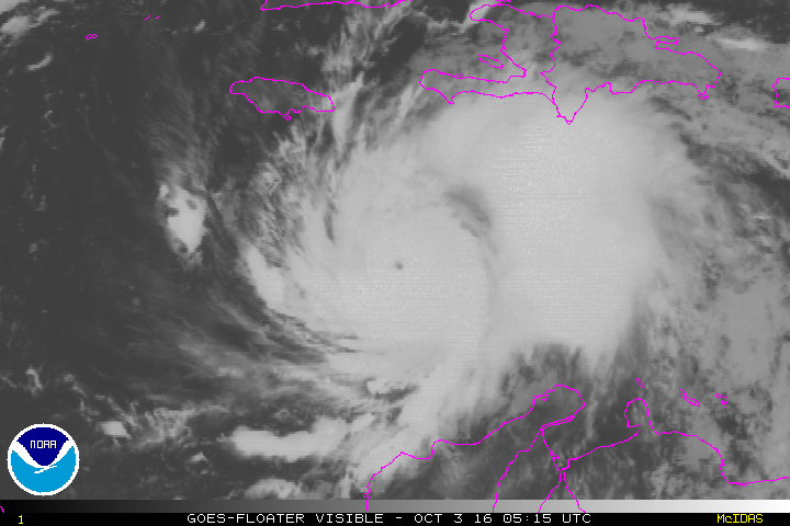
The 11 am update on major hurricane Matthew has it back at a category 4 major hurricane. This is not surprising since it’s been over the very warm waters in the Bahamas. Satellite imagery showed the storm becoming better organized after moving through the land masses of Haiti and Cuba.

Tropical storm watch and warnings are now along the west coast of Florida. Yes the winds will be tropical storm strength even on the other side of Florida! Tropical storm winds start at 39 mph and hurricane starts at 74.

The crazy thing about this storm is the future track. It could loop around and impact Florida a second time! If it does so it will be much weaker then but still it will not be good.

05. October 2016 · Comments Off on Latest on Matthew: Good for North, Bad for South · Categories: Fall, Hurricane · Tags:

145747w_sm

Matthew has weakened slightly and is now a category 3. This was expecting since it was interacting with land masses.

Hurricane warnings are now up for parts of the Florida coast. Hurricane watches have been extended further north.

The latest forecast track has Matthew tracking close to the eastern Florida coast.

There has been a trend for the last 12 hours that is now taking the hurricane out to sea once it gets up to North Carolina. This is good news for the mid-Atlantic and the Northeast US. This is something that still needs to be watched carefully and tracked. We will still see some rain later Saturday into Sunday morning. This will be from the approaching cold front and at this time does not appear to link up with Matthew.

04. October 2016 · Comments Off on Tuesday Afternoon Hurricane Matthew Update · Categories: Fall, Hurricane · Tags:

145747w_sm

As of 2 pm today, major Hurricane Matthew is through Haiti now with eastern Cuba in it’s sights. The storm is still a category 4 with 145 sustained winds with higher gusts. Still moving north but expected to start a more NW turn later on.

14l_tracks_latest

You can see from the map above, the NHC keeps Matthew east of us. That is good news. I suspect Matthew will start interacting with the approaching cold front. If that happens, we should receive health amounts of rain and wind later on Saturday into Sunday morning.

There are currently Hurricane watches up for the east coast of Florida. The Governors of FL and North Carolina have already declared state of emergencies. I also just read that mandatory evacuations have been ordered for along the immediate coast of South Carolina.

Look for Hurricane Watches to be extended further north as time goes on and even Watches into Warnings.

After Cuba, the Bahamas will be impacted Wednesday. Then Florida on Thursday, especially afternoon on.


04. October 2016 · Comments Off on Major Hurricane Matthew Makes Landfall On Haiti · Categories: Fall, Hurricane · Tags:

14606511_1200805219963062_6466437877171226555_n

Matthew is the strongest storm on earth for the moment. The people of Haiti are still recuperating from their devastating earthquake not too long ago. Prayers to anyone in it’s path.

03. October 2016 · Comments Off on Hurricane Matthew Monday Morning Update · Categories: Fall, Hurricane · Tags:

145747w_sm

Above is the latest forecast on major Hurricane Matthew as of 8 am from the National Hurricane Center. Things to note since my last posting:

  1. Matthew became a category 5 hurricane – the strongest level on a scale of 1 to 5. It has weakened slightly since then but still a major hurricane (major hurricane = 3 or higher on the scale based on wind speeds)
  2. The forecast path of Matthew has slowed down by the NHC as seen above. It will only be of the Georgia coast by 2 am Saturday. Clouds and rain will be further north. A slow moving hurricane, while it might be good for the US in this case, is not good for where the hurricane is impacting. Slower = more time for devastating winds and rains

vis-animated

Above is a current satellite loop of the hurricane. The eye is still visible.

14l_tracks_latest

Where does Matthew go from here? The official NHC track is the darker line. At this time it looks to move north towards the outer banks of North Carolina and then get pushed further to the NE from an approaching cold front later this week into the weekend. As of right now this forecast looks good. But hurricanes can have a mind of their own. As you can see above, there a few models that bring him very close to western new jersey area! Continue to stay current on the storm.

30. September 2016 · Comments Off on Matthew Becomes Major Hurricane · Categories: Fall, Hurricane · Tags:
Hurricane Matthew 11am Update

Hurricane Matthew 11am Update

Matthew is now a category 3 hurricane which is considered major. So why am I blogging about this in a western New Jersey weather blog? Well look at the map above and see which way the National Hurricane Center thinks it will be heading. It looks to move up the east coast of the US next week. The big question is how close does it get to the coast and does it curve away at any point?

My early thoughts are it will continue north to near the North Carolina coast. then a cold front which should be moving east across the country next week will act as a kicker to move it further to the east and not have an impact any further north, other than rough seas of course.

28. September 2016 · Comments Off on Tropical Storm Matthew Forms · Categories: Fall, Hurricane · Tags:

Tropical Storm Mathew

Tropical storm Matthew formed today. The storm will stay south of Puerto Rico as you see in the map above. Beyond that the track gets very interesting. As you can see the National Hurricane Center predicts the storm to turn to the north and approach Cuba.

After that things get interesting. Will the hurricane go near Florida? East Coast? Some of the extended models have it moving up the East Coast next week so we need to keep an eye on it.

New Jersey is no stranger to October Hurricanes. Let’s hope we only get some much needed rain from this and nothing more!

05. September 2016 · Comments Off on Hermine And The Hot Week Ahead · Categories: Fall, Hurricane, Summer · Tags: ,

093741W_sm

Here’s the Monday late morning update on Hermine. The storm is *finally* retrograding back to the west. But it is too far east to have any *significant* impacts to us here in western New Jersey. We will see more thin high clouds today than yesterday. There may even be more of a breeze than yesterday too. Expect high temperatures on Labor Day to be in the low 80’s. Overall great holiday weather.

Except if you at the shore. The shore will have more clouds today and it will be windy. You shouldn’t go into the warm water more than knee deep due to the rip current potential. And there will be continued beach erosion and some flooding at times of high tide. But it will be a nice enough day to get out and relax and visit shore vendors and enjoy the last day of the extended weekend.

7day

Hermine will take her time departing the area. In her wake will be a return to hot and humid weather. Just what we all wanted to see with school back in session. Expect high temperatures Tuesday-Friday in the upper 80’s the low 90’s on some days. We could start to see some scattered afternoon showers as early as Wednesday but the rain chances increase more as the week wears on. Keep in mind we are very dry and under drought conditions.

04. September 2016 · Comments Off on Hermine Sunday Morning Upgrade · Categories: Fall, Hurricane, Summer · Tags: ,

093741W_sm

At the beginning of Hermine’s landfall she was going further north and west that forecast. Yesterday she decided to stay further east and south. Perhaps it was the strong high pressure to the north. Regardless the storm is further offshore than forecast.

As you can see above, we are not completely off the hook. It is forecast to come back towards the coast a little but this will not be as close as originally thought. We will have no rain from this in western New Jersey. Today will be a partly sunny beautiful day. The Jersey shore will continue to see high waves, beach erosion and tital flooding at times of high tide.

If Hermine does turn back towards the coast, conditions will not be felt until later today in Monday.

vis-animated

03. September 2016 · Comments Off on Hermine Saturday Update · Categories: Hurricane · Tags: ,

093741W_sm

New since the last post: Hermine is forecast to become a hurricane again once it re-enters the warm waters of the Atlantic. This may not occur until later Monday into Tuesday. The storm will be very slow moving and may not be out of the area until Thursday.

At this time, we may not get very much rainfall from this system in western New Jersey. We may only see 1/2″ of rain. Some computer models don’t give us any rain. Winds will be gusty – even inland.

The most impact from this storm will be along the shore. Winds there will be much stronger and there will be coastal flooding, especially at times of high tide. There will be MANY high tide cycles with this storm since it will be around for so long!

Tropical storm warnings now up for the Jersey shore.

Today, Saturday will be a relatively nice day but we will see an increase in clouds from Hermine. We shouldn’t start to feel the impact of the storm until later Sunday.

Animated Social Media Icons by Acurax Responsive Web Designing Company
Visit Us On TwitterVisit Us On FacebookVisit Us On PinterestVisit Us On YoutubeVisit Us On Instagram