14. July 2017 · Comments Off on More Rain Today · Categories: Summer, thunderstorms · Tags: , ,

Parts of western New Jersey picked up a good amount of rain yesterday. Stewartsville received 0.83 from the late afternoon thunderstorms and an additional 0.10″ overnight.

Severe weather threat stays south of western New Jersey on Friday

Severe weather threat stays south of western New Jersey on Friday

While Friday will be cooler than the last few days, the humidity will still be very uncomfortable. The best chances for any severe weather look to be to the south of western New Jersey – but not that far away. So keep an eye to the sky.

More moderate rain heading to western New Jersey

More moderate rain heading to western New Jersey

Good news is nicer weather returns for the weekend. Then look for another warm/hot/humid spell next week. It is summer after all!

13. July 2017 · Comments Off on Thunderstorms Approaching Area · Categories: Summer, thunderstorms · Tags:
...A STRONG THUNDERSTORM WILL AFFECT WESTERN HUNTERDON...SOUTHWESTERN
WARREN...CENTRAL LEHIGH...NORTH CENTRAL BUCKS AND SOUTHERN
NORTHAMPTON COUNTIES...

AT 328 PM EDT, A STRONG THUNDERSTORM WAS LOCATED OVER COFFEETOWN, OR
NEAR ALLENTOWN, MOVING EAST AT 30 MPH.

WIND GUSTS UP TO 30 MPH AND PEA SIZE HAIL ARE POSSIBLE WITH THIS
STORM.

HEAVY RAINFALL IS ALSO OCCURRING WITH THIS STORM...AND MAY CAUSE
PONDING ON ROADWAYS AND POOR DRAINAGE AREAS. DO NOT DRIVE YOUR
VEHICLE THROUGH FLOODED ROADWAYS.

OCCASIONAL CLOUD TO GROUND LIGHTNING IS OCCURRING WITH THIS STORM.
LIGHTNING CAN STRIKE 15 MILES AWAY FROM A THUNDERSTORM. IF YOU SEE
LIGHTNING OR HEAR THUNDER SEEK A SAFE SHELTER INSIDE A BUILDING OR
VEHICLE.

LOCATIONS IMPACTED INCLUDE...
ALLENTOWN, EASTON, BETHLEHEM, FORKS, EMMAUS, NORTHAMPTON, WILSON,
HELLERTOWN, NAZARETH, BATH, HARMONY, ALPHA, WALNUTPORT, FERNDALE,
BELFAST, WEST EASTON, MILFORD, TATAMY, BLOOMSBURY AND RIEGELSVILLE.
13. July 2017 · Comments Off on Hottest Day of the Year · Categories: Summer, thunderstorms · Tags: ,
Hottest day of the summer so far today in western New Jersey

Hottest day of the summer so far today in western New Jersey

I think its safe to say that today will be the hottest day of the warm season so far. Temperatures combined with humidity levels will make it feel miserable and borderline dangerous and unhealthy in some locations.

SPC has placed all of western New Jersey in a slight risk of severe weather today

SPC has placed all of western New Jersey in a slight risk of severe weather today

With warm and humid weather comes the chance of sever weather. Look for the potential for strong storms later on today, tonight and even tomorrow.


03. July 2017 · Comments Off on Marginal Chance of Severe Weather Today · Categories: Summer, thunderstorms · Tags:
The SPC has placed all of western New Jersey in a marginal risk of severe weather this afternoon

The SPC has placed all of western New Jersey in a marginal risk of severe weather this afternoon

With warm summer-time temperatures today along with a slight trigger there is a marginal risk of severe thunderstorms later this afternoon. The greatest threat appears to be wind gust if you do receive a storm – which will be scattered. Greatest threat right now appears to be 4-6 pm or in that vicinity.

01. July 2017 · Comments Off on Strong Thunderstorms Possible This Afternoon · Categories: Summer, thunderstorms · Tags:
strong thunderstorms are possible this afternoon in western New Jersey

strong thunderstorms are possible this afternoon in western New Jersey

The Storm Prediction Center has placed all of western New Jersey in a slight risk area for thunderstorms today. The greatest threat will be this afternoon from 4-8 pm.

Those in eastern PA yesterday were treated to quite a light show last night. I was driving back home to western New Jersey around 8:30-pm and there was so much cloud to cloud lightening it was spectacular!

24. June 2017 · Comments Off on Heavy Rain Overnight · Categories: Flash Floods, precipitation, Summer · Tags:
Heavy rain overnight in Stewartsville NJ 2.68" LKC-001

Heavy rain overnight in Stewartsville NJ 2.68″ LKC-001

The first round of rain came around 5-6pm resulting in nearly 1″ Then we had another batch around 9 pm that gave us about 1/4″ The rest came overnight with probably the highest amounts in the 3-6 am time period.

Above is a graph from my station. It clearly shows the bulk came around 3-4 am!

Here are more photos from yesterday including a faint rainbow.

23. June 2017 · Comments Off on Severe Thunderstorm Watch until 10 pm · Categories: Summer, thunderstorms · Tags:

A cold front approaching combined with the remnants of Cindi will give western new jersey a chance for some rain and thundershowers for the next 12 hours!

Some storms are already giving warnings in eastern PA and they are heading towards are area.

21. June 2017 · Comments Off on Slight Chance Thundershower Wednesday · Categories: Summer · Tags: ,

First off welcome to Summer! The Summer Solstice arrive just after midnight this morning. Longest day(light) of the year today! If you like warmer weather, welcome to summer. If you don’t like warmer weather, the day(light) will slowly start getting shorter which will lead (eventually) to cooler weather!

There is a slight chance of a thundershower this afternoon. Most areas will not see anything and this will not be widespread.

Tomorrow Thursday should be a nice day with humidity increasing in the afternoon. Friday should be an active day with a cold front approaching the area. At this time Saturday look OK after a few showers in the morning potentially. This all depends on what the remnants of Tropical Storm Cindi does. She is forecast to stay south of our area as the front pushes her south.

19. June 2017 · Comments Off on Severe Thunderstorm Warning Warren and Hunterdon · Categories: thunderstorms · Tags:
THE NATIONAL WEATHER SERVICE IN MOUNT HOLLY NJ HAS ISSUED A

* SEVERE THUNDERSTORM WARNING FOR...
SOUTHWESTERN MORRIS COUNTY IN NORTHERN NEW JERSEY...
HUNTERDON COUNTY IN NORTHWESTERN NEW JERSEY...
SOUTHWESTERN WARREN COUNTY IN NORTHWESTERN NEW JERSEY...
NORTHWESTERN SOMERSET COUNTY IN NORTHERN NEW JERSEY...
NORTHWESTERN BUCKS COUNTY IN SOUTHEASTERN PENNSYLVANIA...
SOUTHEASTERN NORTHAMPTON COUNTY IN EASTERN PENNSYLVANIA...

* UNTIL 445 PM EDT

* AT 356 PM EDT, SEVERE THUNDERSTORMS WERE LOCATED ALONG A LINE
EXTENDING FROM NEAR HARMONY TO RIEGELSVILLE TO PERKASIE, MOVING
NORTHEAST AT 50 MPH.

HAZARD...60 MPH WIND GUSTS.

SOURCE...RADAR INDICATED.

IMPACT...EXPECT DAMAGE TO TREES AND POWER LINES.

* SEVERE THUNDERSTORMS WILL BE NEAR,
EASTON, ALPHA AND MILFORD AROUND 400 PM EDT.
WASHINGTON, BLOOMSBURY, PLEASANT VALLEY AND BRASS CASTLE AROUND
405 PM EDT.
BYRAM, TINICUM, CLINTON, HAMPTON AND OTTSVILLE AROUND 410 PM EDT.
HIGH BRIDGE, GLEN GARDNER, FRENCHTOWN, LEBANON, ANNANDALE AND
ERWINNA AROUND 415 PM EDT.
CALIFON, SAND BROOK, LONG VALLEY AND SERGEANTSVILLE AROUND 420 PM
EDT.
FLEMINGTON AROUND 425 PM EDT.
PEAPACK AND GLADSTONE, CHESTER, SUCCASUNNA-KENVIL AND SUCCASUNNA
AROUND 430 PM EDT.
DOVER, WHARTON, MENDHAM AND WHITE HOUSE STATION AROUND 435 PM EDT.

OTHER LOCATIONS IMPACTED BY THESE SEVERE THUNDERSTORMS INCLUDE
TELFORD, SELLERSVILLE, RARITAN, BERNARDSVILLE, RICHLANDTOWN,
PHILLIPSBURG AND SILVERDALE.

PRECAUTIONARY/PREPAREDNESS ACTIONS...

FOR YOUR PROTECTION MOVE TO AN INTERIOR ROOM ON THE LOWEST FLOOR OF A
BUILDING.

IN ADDITION TO LARGE HAIL AND DAMAGING WINDS...FREQUENT CLOUD TO
GROUND LIGHTNING IS OCCURRING WITH THIS STORM. MOVE INDOORS
IMMEDIATELY. REMEMBER...IF YOU CAN HEAR THUNDER...YOU ARE CLOSE
ENOUGH TO BE STRUCK BY LIGHTNING.

TORRENTIAL RAINFALL IS OCCURRING WITH THESE STORMS, AND MAY LEAD TO
FLASH FLOODING. DO NOT DRIVE YOUR VEHICLE THROUGH FLOODED ROADWAYS.

&&


HAIL...<.75IN
WIND...60MPH

19. June 2017 · Comments Off on Severe Thunderstorm Watch Until 8 pm Tonight · Categories: Summer, thunderstorms · Tags:

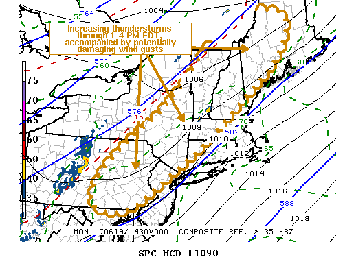
URGENT – IMMEDIATE BROADCAST REQUESTED
Severe Thunderstorm Watch Number 354
NWS Storm Prediction Center Norman OK
1115 AM EDT Mon Jun 19 2017

The NWS Storm Prediction Center has issued a

* Severe Thunderstorm Watch for portions of
Connecticut
Western and Central Massachusetts
Northern New Jersey
Eastern New York
Eastern Pennsylvania
Southern Vermont
Coastal Waters

* Effective this Monday morning and evening from 1115 AM until
800 PM EDT.

* Primary threats include…
Scattered damaging wind gusts to 70 mph likely
Scattered large hail events to 1.5 inches in diameter possible
A tornado or two possible

SUMMARY…Scattered thunderstorms are expected to intensify across
the watch area through the afternoon, with the strongest cells
capable of damaging wind gusts and some hail.

The severe thunderstorm watch area is approximately along and 75
statute miles east and west of a line from 45 miles southeast of
Harrisburg PA to 35 miles northwest of Keene NH. For a complete
depiction of the watch see the associated watch outline update
(WOUS64 KWNS WOU4).

PRECAUTIONARY/PREPAREDNESS ACTIONS…

REMEMBER…A Severe Thunderstorm Watch means conditions are
favorable for severe thunderstorms in and close to the watch area.
Persons in these areas should be on the lookout for threatening
weather conditions and listen for later statements and possible
warnings. Severe thunderstorms can and occasionally do produce
tornadoes.

&&

AVIATION…A few severe thunderstorms with hail surface and aloft to
1.5 inches. Extreme turbulence and surface wind gusts to 60 knots. A
few cumulonimbi with maximum tops to 500. Mean storm motion vector
25035.

…Hart

Floating Social Media Icons by Acurax Wordpress Designers
Visit Us On TwitterVisit Us On FacebookVisit Us On PinterestVisit Us On YoutubeVisit Us On Instagram