30. December 2017 · Comments Off on Light Snow Saturday Morning · Categories: snow, winter · Tags: , ,
Radar at 7:30 am

Radar at 7:30 am

As you wake up this Saturday morning you will find light snow falling in western New Jersey with temperatures in the mid teens.

NWS Snow forecast

NWS Snow forecast

As seen in the radar above, the heaviest bands of snow appear to be setting up to our south. As a result those locations could see up to 3″ of snow. The rest of the area should see up to 2″ of light snow.

The NWS has issued a winter weather advisory for areas to our south.

The light snow should let up by early afternoon. Then we should see some flurries or perhaps some snow showers this afternoon. Then more bitter cold air returns after our “balmy” day today…

29. December 2017 · Comments Off on Light Snow For Saturday · Categories: snow, winter · Tags:


NWS forecast for snow on Saturday

NWS forecast for snow on Saturday

Still cold out but at least the wind is not as strong. As of right now we’re at the high temperature for yesterday and it’s only 1:30 pm so hopefully we’ll get in the low to mid 20’s.

Periods of light snow should arrive just after daybreak on Saturday and move in from SW to NE. I still believe we are going to receive a coasting to 2″ overall in western New Jersey. Recent computer guidance is suggesting the “heaviest” band will be from NW to SE across western NJ.

Something to keep in mind is it will be in the mid to upper 20’s tomorrow during the snow so our snow ratio will be higher. This will make the snow lighter and fluffier. Usually snow like that accumulates more (but also compacts down more too)

28. December 2017 · Comments Off on Bitter Cold Weather Remains; Light Snow For Saturday · Categories: snow, winter · Tags:
NWS snow forecast for Saturday

NWS snow forecast for Saturday

This cold weather period has been quite impressive. Most areas of western New Jersey did not get out of the teens for high temperatures today! Furthermore the New Year Eve weather looks to be the coldest since the 1960’s!

The cold weather looks to remain at least for another week. The only positive note is there will be times when it won’t be as windy which should make it *feel* warmer at least. Tomorrow, Friday is one of those less windy days.

Saturday doesn’t look too wind either. But we should have some periods of light snow to deal with. The system doesn’t look that impressive for western New Jersey. At this time I’m thinking coating to 1-2″ max. If it wasn’t so cold I would forecast less but since it is so cold the snow will be light and fluffy.

Then back into the windy freezer on Sunday and Monday. Some of the long range computer models are hinting at a possible coastal snow storm by the middle of next week. I’m not biting yet since several days ago they showed this Saturday’s storm for us being significant of which it won’t be – for us.

Stay warm!

28. December 2017 · Comments Off on I’m Back! · Categories: weather discussion · Tags: ,

Well that was fun. I realized a while ago that “something” happened preventing me from logging onto this website/blog. But I never had the time to troubleshoot it. I finally had the time today not that the holidays are almost over. Funny thing is I started chatting with tech support on how to fix it and while I was waiting on them, I figured out how to fix it!

So that brings me to an important point. My website was up – I just could make any updates. Sooooooo if that happens again, or if you notice there haven’t been any updates in a while PLEASE go to my Facebook page the accompanies this at:

https://www.facebook.com/westernjerseywx/


26. October 2017 · Comments Off on Rain still on track for Sunday · Categories: Fall · Tags: , ,
Rain forecast for Sunday into Monday

Rain forecast for Sunday into Monday

Rain is still forecast for Sunday into Monday but amounts for western jersey are reduced per the above graphic. But 2″ would still be a much beneficial rainfall. I just hope the trend doesn’t continue and the heavier rain gets pushed to the east…

25. October 2017 · Comments Off on Closer to normal temperatures; Rain on Sunday · Categories: Fall · Tags: ,
Rainfall forecast for Sunday into Monday

Rainfall forecast for Sunday into Monday

The rainfall yesterday was on the lighter side of what was forecast. But some rain is better than no rain. Stewartsville received 0.66″ of rain.

Today will feature high temperatures in the 60’s which is above the seasonable normal of 61. Tomorrow will be slightly below normal with a high of 59. Then we moderate late week into the weekend. Saturday looks very nice but rain is forecast to move into the area on Sunday and it could be a good soaking as shown in the map above.

23. October 2017 · Comments Off on Potentially severe weather ushers in back to normal · Categories: Fall, precipitation, thunderstorms · Tags:
Severe weather threat for Tuesday

Severe weather threat for Tuesday

All good things must come to an end. The string of above normal temperatures for western jersey for late October will come to an end starting tomorrow. That change might arrive with some potentially severe weather. Right now the best time looks like late morning to mid day. This could extend later on to the east.

As you most of you know we are also very dry. We look to receive 3/4″-1″ of rain from this system.

The we return to normal and maybe a little below normal on Thursday as cooler weather returns to western new jersey. Out normal high temperature this time of year is 62 degrees.


28. September 2017 · Comments Off on Fall Arrives….. One week Late · Categories: Fall · Tags: , ,
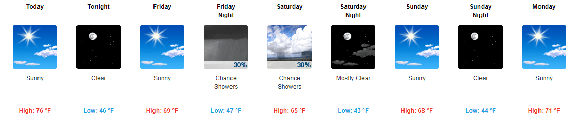
7 Day forecast for western New Jersey

7 Day forecast for western New Jersey

The early fall heat wave is over! Much more seasonable and enjoyable weather is finally here. Or back if you remember the early part of the month! Some warmer and above normal weather looks to return around the middle of next week but ti doesn’t look to be as warm as what we just had – hopefully only mid 70’s for daytime highs.

8-14 day precipitation forecast

8-14 day precipitation forecast

8-14 day temperature forecast

8-14 day temperature forecast

In looking ahead to the first half of October for western Jersey, warm and dry trend of late looks to continue. My lawn is starting to show signs of dryness – first time this warm season!

HOpefully we will still have cool nights. Fall foliage likes warm days and cool nights to bring out the best and brightest colors!

22. September 2017 · Comments Off on Autumnal Equinox · Categories: Fall · Tags: , ,

Happy first day of fall 2017! While it may not feel like fall like outside it officially begins shortly after 4 pm today.

6-10 day temperature outlook

6-10 day temperature outlook

Warmer temperatures will continue well into most of next week as well. In fact we will unfortunately flirt with the 90 degree mark Sunday and Monday!

Fall foliage report

Fall foliage report

So now that it’s fall we need to start thinking about the beautiful colors of fall. There is some colors out there already.

Post tropical storm Jose is still out there but slowly weakening and should diminish without causing any issues. Hurricane Maria should stay off-shore the eastern US after devastating Puerto Rico and other nearby islands.

Cooler weather should hopefully return by October.

19. September 2017 · Comments Off on Hurricane Jose Stays Offshore; Dangerous Hurricane Maria Approaches Puerto Rico · Categories: Hurricane · Tags: ,
Hurricane Jose forecast track

Hurricane Jose forecast track


With a Cat 1 hurricane sitting off the east coast you would think we would be a little more alarmed. Luckily Jose is behaving himself and transitioning to a nor’easter instead of a tropical system. Most of the impacts will be felt near the shore with rough surf and beach erosion.

 
Some light rain showers could move into portions of western New Jersey today, especially eastern sections. Above normal temperatures and humidity will continue for at least another week. We are 10 degrees above normal believe it or not!
 
Dangerous Cat 5 Hurricane Maria forecast track

Dangerous Cat 5 Hurricane Maria forecast track


Dangerous hurricane Maria is in the Caribbean. We will keep an eye on her after she passes over Puerto Rico. Current forecast is for her to gradually curve out to sea next week. She will continue to give us and the entire eastern seaboard rough surf conditions.
Floating Social Media Icons by Acurax Wordpress Designers
Visit Us On TwitterVisit Us On FacebookVisit Us On PinterestVisit Us On YoutubeVisit Us On Instagram