11. March 2018 · Comments Off on Monday Night Into Tuesday Storm · Categories: snow · Tags: , ,

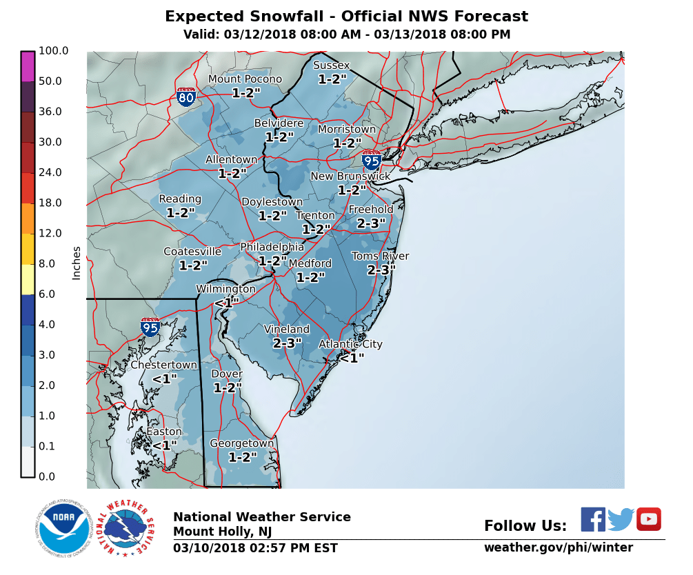
NWS snow forecast

Sunday night will be a cold night with low temperatures near 20 which is colder than the last few nights. Monday will feature increasing clouds and continued cool with night in the mid to upper 30’s. Normal high this time of year is 47. Light snow should start to move into western New Jersey from SW to NE in the evening around 8 pm give or take. Periods of light snow should continue overnight and end Tuesday morning. At this time I’m forecasting a coating to 2″ for most locations of western New Jersey. There will be more snow from this storm to the north and east. Here is a forecast map wider in scope:

10. March 2018 · Comments Off on First Thoughts On Monday Night Into Tuesday Storm · Categories: snow · Tags: ,

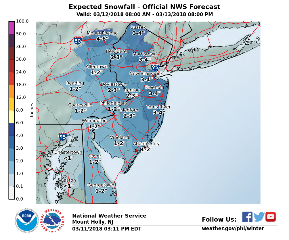
Initial NWS snow forecast for Tuesday

Let me start off by saying the next storm, which is now a Monday night into Tuesday time frame, has always been forecast to occur. For the past couple of days it’s influence looks to stay to our south and east. The past couple of computer runs are now suggesting it may travel a little closer to our area.

Even if this didn’t happen, there were indications there was going to be a little light snow with this event from an upper level low pressure system that was going to pass overhead Tuesday into Wednesday.

Right now the above map is a good starting point for any snow accumulations in our area. If we truly only get a few inches, it will primarily only accumulate on colder surfaces and not roads. Unfortunately trees are colder surfaces and many of them are weak from the last 2 storms and could result in some power outages but let’s hope that is at a minimum and some people are STILL without power from the FIRST storm.

The things to keep an eye on now is the trend. If the computer model keep the trend closer to us then we can plan accordingly.

Also note the more snow will fall further to the east and south of western New Jersey as it looks at this time.

Regardless this will be another nor’easter storm that will have big impacts to eastern New England. The pattern of strong storms does look to end with this one for now.

07. March 2018 · Comments Off on Major Winter Storm Ending · Categories: snow, winter · Tags:

6.5″ Snow in Stewartsville

I don't expect any additional snow in western sections - only further east and north.

525 PM EST Wed Mar 7 2018

...Major winter storm ending this evening...

Warren-Morris-Hunterdon-Somerset-
Including the cities of Washington, Morristown, Flemington, and Somerville
525 PM EST Wed Mar 7 2018

...WINTER STORM WARNING REMAINS IN EFFECT UNTIL 3 AM EST THURSDAY...

* WHAT...Heavy snow. Additional snow accumulations up to 2 inches   are expected.

* WHERE...Warren, Morris, Hunterdon and Somerset Counties.

* WHEN...Until 3 AM EST Thursday.

* ADDITIONAL DETAILS...Plan on difficult travel conditions,   including during the evening commute. Be prepared for
  significant reductions in visibility at times.

PRECAUTIONARY/PREPAREDNESS ACTIONS...

A Winter Storm Warning for snow means severe winter weather
conditions will make travel very hazardous or impossible. If you
must travel, keep an extra flashlight, food and water in your
vehicle in case of an emergency. The latest road conditions for
the state you are calling from can be obtained by calling 5 1 1.
07. March 2018 · Comments Off on Heavier Snow On The Way · Categories: snow · Tags:

1-2″ per hour snow rates developing soon

935 AM EST Wed Mar 7 2018

...INCREASING SNOWFALL RATES BY LATER THIS MORNING AND ESPECIALLY
THIS AFTERNOON...

Bands of very heavy snow with rates of nearly 2 inches per hour
will develop across the region by later this morning and
especially this afternoon. This will quickly turn any wet pavement
into slush and then snow covered, resulting in very hazardous or
impossible travel on all unplowed roads by late this afternoon.
Visibility will be significantly reduced at times to a quarter
mile or less and northerly winds will become gusty. This is when
tree limbs may break or some trees are uprooted, especially where
temperatures hover near 32 degrees. The result would be additional
power outages.

As snowfall rates increase to 1 inch or more per hour, accumulation
on roads will quickly become much more efficient and this will
make it difficult for road crews to keep up. Travel is not
recommended.
06. March 2018 · Comments Off on Storm Update and Timing Wednesday · Categories: snow, winter · Tags:

NWS Snow Forecast for Wednesday

I wanted to get an update out for the snow storm on Wednesday, March 6. I also want to give an idea of storm timing. IN general things are slowing down a little.

This Evening

There will be some rain or wet snow shower around starting at 8 pm or thereafter, These will be showers in nature and generally not a big deal. The temperature will be above freezing

Over night

Rain and snow showers will become periods of light wet snow. I’m expecting a coating to a couple of inches by daybreak tomorrow

Wednesday Morning

Many folks may wake up (especially early) and look out the window and say ‘this is our big storm’ and be confused/disappointed. I do not anticipate the snow getting heavy until mid to late morning. Certainly by lunch time the snow should be coming down hard at the rate of 1-2″ per hour

Wednesday Afternoon

From mid to late morning through most of the afternoon is where we will see our heaviest snow. It should come in waves/bands. Where these bands setup will determine who gets what. Look for snow at the rate of 1-2″ per hour

Wednesday Evening

The snow should start to taper down from west to east from early evening on as it looks now. There will still be periods of light snow and flurries into the overnight.

Snow Amounts

I’m pretty confident western New Jersey will receive 6-12″ of snow. There will be some locally higher amounts where the heavy snow bands setup.

03. March 2018 · Comments Off on Friday Storm Recap · Categories: snow, spring · Tags:

Snow on bulbs in Stewartsville.

I think its safe to say this storm was another over-producer. 3.1″ of very wet snow was recorded in Stewartsville. I never had to shovel most of my driveway – only the part that was in the shade of the house.

Here are some other snow totals:

...Warren County...
    Oxford                 6.0   415 PM  3/02  Social Media            
    Allamuchy              6.0   748 PM  3/02  Trained Spotter         
    Hackettstown           5.0   540 PM  3/02  Trained Spotter
...Northampton County...
    Hellertown             6.0   400 PM  3/02  Social Media            
    Bethlehem              5.6   330 PM  3/02  Trained Spotter         
    Cherry Hill            5.5  1020 PM  3/02  Trained Spotter         
    Easton                 4.3   700 PM  3/02  Social Media            
    Martins Creek          3.2   700 PM  3/02  Trained Spotter
01. March 2018 · Comments Off on Winter Weather Advisory Issued Friday into early Saturday · Categories: spring, weather discussion, winter · Tags:

NWS Snow Forecast

URGENT - WINTER WEATHER MESSAGE
National Weather Service Mount Holly NJ
341 PM EST Thu Mar 1 2018

NJZ007-008-PAZ062-020845-
/O.NEW.KPHI.WW.Y.0011.180302T1600Z-180303T0900Z/
Warren-Morris-Northampton-
Including the cities of Washington, Morristown, Bethlehem,
and Easton
341 PM EST Thu Mar 1 2018

...WINTER WEATHER ADVISORY IN EFFECT FROM 11 AM FRIDAY TO 4 AM
EST SATURDAY...

* WHAT...Wet snow expected. Total snow accumulations of 3 to 6
  inches at higher elevations above 800 feet and 2 inches or less
  in the valleys are expected.

* WHERE...In New Jersey, Warren and Morris counties. In
  Pennsylvania, Northampton county.

* WHEN...Rain will transition to snow initially along the high-
  elevation ridges around midday Friday and then closer to mid
  afternoon in the valleys. The snow will be heavy at times Friday
  afternoon and evening with snowfall rates of 1 inch per hour
  possible. The snow is expected to end from west to east
  overnight.

* ADDITIONAL DETAILS...Plan on very difficult travel conditions,
  including during the evening commute on Friday. The combination
  of strong northwest winds gusting to 50 mph and heavy snow
  could create near-blizzard conditions with visibilities below
  one-half mile at times. The heavy, wet nature of the snow and
  strong winds will likely cause damage to trees and power lines
  that will lead to scattered power outages, especially at higher
  elevations.

PRECAUTIONARY/PREPAREDNESS ACTIONS...

A Winter Weather Advisory for wet snow means periods of wet snow
will cause primarily travel difficulties. Be prepared for snow
covered roads and limited visibilities, and use caution while
driving. The latest road conditions for the state you are calling
from can be obtained by calling 5 1 1.
01. March 2018 · Comments Off on Nor’Easter Friday into Friday Night · Categories: weather discussion · Tags: , , , , ,

NWS Watches and Warnings

Whenever you see the watches and warnings map above lit up like a Christmas tree, you know something is going on. The Nor’easter that will move into western New Jersey later tonight into Friday looks to be a formidable storm. There is a Flood Watch and a High Wind Watch for western New Jersey. There is a Winter Storm Watch for Sussex county further to the north.

NWS Snow Forecast

the biggest change I want to pass along at this time is the *potential* for more wet snow on Friday. I’m increasing my forecast for 1-3″ of heavy, wet snow that will accumulate mostly on colder surfaces.

Friday is a day where rain will change to wet snow and come down heavy at times as the wind increases. But the temperature will remain above freezing and all of this will occur during the day. There are some computer models suggesting we get closer to 6″ but I don’t see that happening at this point.

Further to the north and in elevated areas, more snow will accumulate – perhaps 3-6″ or more.

Timing: rain will start after 3 pm today. Rain should be light to moderate later this afternoon and the first part of this evening. Rain will then become heavy at times later tonight. Winds will pick up after midnight as well. Rain will gradually change to a wet snow Friday morning and continue off an on all day as winds increase.

What: Heavy rain, wind and wet snow on Friday. 1-2″ of rain. Winds gusting to 50-60 mph on Friday

I’ll continue to monitor and update as things change

01. March 2018 · Comments Off on High Wind Watch for Friday · Categories: winds · Tags:

High Wind Watch for Friday

URGENT - WEATHER MESSAGE
National Weather Service Mount Holly NJ
340 AM EST Thu Mar 1 2018

...POTENTIALLY DAMAGING WINDS ARE EXPECTED FRIDAY AND FRIDAY
NIGHT...

.Low pressure will intensify near the Northeast coast on Friday.
This will bring strong to potentially damaging northwest winds to
the region Friday and Friday night.

NJZ007>010-015-PAZ060>062-070-071-101>106-012100-
/O.EXA.KPHI.HW.A.0001.180302T1200Z-180303T1200Z/
Warren-Morris-Hunterdon-Somerset-Mercer-Berks-Lehigh-Northampton-
Delaware-Philadelphia-Western Chester-Eastern Chester-
Western Montgomery-Eastern Montgomery-Upper Bucks-Lower Bucks-
Including the cities of Washington, Morristown, Flemington,
Somerville, Trenton, Reading, Allentown, Bethlehem, Easton,
Media, Philadelphia, Honey Brook, Oxford, West Chester,
Kennett Square, Collegeville, Pottstown, Norristown, Lansdale,
Chalfont, Perkasie, Morrisville, and Doylestown
340 AM EST Thu Mar 1 2018

...HIGH WIND WATCH IN EFFECT FROM FRIDAY MORNING THROUGH SATURDAY
MORNING...

The National Weather Service in Mount Holly has issued a High
Wind Watch, which is in effect from Friday morning through
Saturday morning.

* WINDS...Northwest 20 to 30 mph with gusts up to 60 mph.

* TIMING...Strong winds will develop during the morning hours
  Friday from south to north across the watch area. Winds will
  peak during the late morning through the early evening hours
  before diminishing somewhat late Friday night.

* IMPACTS...Damaging winds will blow down trees and power lines.
  Numerous power outages are possible. Additionally, rain may
  change to snow Friday and Friday evening, especially northwest
  of Philadelphia. The snow combined with the wind may produce
  localized whiteout conditions. Travel may become very difficult
  as a result.

PRECAUTIONARY/PREPAREDNESS ACTIONS...

A High Wind Watch means there is the potential for a hazardous
high wind event. Sustained winds of at least 40 mph...or gusts of
58 mph or stronger may occur. Continue to monitor the latest
forecasts.

28. February 2018 · Comments Off on Flood Watch · Categories: flood watch, spring · Tags:

Flood Watch

345 PM EST Wed Feb 28 2018

...FLOOD WATCH IN EFFECT FROM LATE THURSDAY NIGHT THROUGH LATE
FRIDAY NIGHT...

The National Weather Service in Mount Holly has issued a

* Flood Watch for portions of New Jersey and Pennsylvania,
  including the following areas, in New Jersey, Camden, Coastal
  Ocean, Eastern Monmouth, Hunterdon, Mercer, Middlesex, Morris,
  Northwestern Burlington, Ocean, Somerset, Southeastern
  Burlington, Warren, and Western Monmouth. In Pennsylvania,
  Eastern Montgomery, Lehigh, Lower Bucks, Northampton,
  Philadelphia, Upper Bucks, and Western Montgomery.

* From late Thursday night through late Friday night

* Rain is expected to develop Thursday afternoon and persists
  through all of Friday and maybe into Friday night. The heaviest
  rain is expected across the northern half of New Jersey and
  east-central Pennsylvania. This includes the Raritan and
  Passaic basins in New jersey and portions of the Delaware Basin.

* As the rain falls later on Thursday and into Friday, low-lying
  and poor drainage flooding is likely where the heaviest rain
  occurs. In addition, as this rainfall runs off into larger
  streams and rivers, flooding will also be possible Friday night
  into Saturday.

PRECAUTIONARY/PREPAREDNESS ACTIONS...

A Flood Watch means there is a potential for flooding based on
current forecasts.

You should monitor later forecasts and be alert for possible
Flood Warnings. Those living in areas prone to flooding should be
prepared to take action should flooding develop.
Floating Social Media Icons by Acurax Wordpress Designers
Visit Us On TwitterVisit Us On FacebookVisit Us On PinterestVisit Us On YoutubeVisit Us On Instagram