09. February 2015 · Comments Off on Freezing Rain, Sleet For Monday · Categories: snow, weather discussion, weather forecast, winter · Tags: , ,

20150209_072343

Monday morning update for western new jersey has most area schools closed today. Light rain started over night and transitioned to freezing rain and sleet as the temperature slowly dropped. Most untreated surfaces are slipper as seen in the above photo.

image

I was impressed with the steady rain of temperature decline since midnight. In researching this further and looking at overnight observation the colder air actually came in from the east and north. Portions of long island were colder than NJ. And now NJ is colder than portions of PA. This will all even out as the coastal storm strengthens.

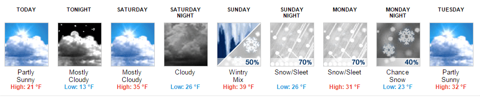
As this trend continues today, we will see more sleet than freezing rain. Then some light snow will transition in this afternoon. I still expect only a coating to perhaps 2” in most areas. Northern sections of western new jersey will experience slightly more snow as they will have cold longer.

image

After today conditions improve. Tuesday we should see temperatures back up above freezing. Then another artic front will pass through the area Wednesday night into Thursday morning with a little light snow but also the return of very cold air – perhaps the coldest of the season. Hopefully I’ll be able to stop saying that soon…

08. February 2015 · Comments Off on Winter Storm Update for Monday · Categories: snow, weather discussion, weather forecast, winter · Tags: , ,

10171244_925583107461024_6365667829035006741_n10924695_925583104127691_7670384373311748943_n

Sunday will remain mostly cloudy and rather mild in western new jersey today with high temperatures around 40. There is some light scattered rain falling but is not reaching the ground since it’s still too dry outside.

I expect light scattered rain showers to move into the area this evening and overnight. I expect our temperatures to remain above freezing until at least the early morning commute on Monday. This means that any precipitation that falls should be mainly rain. Since the colder air, which is slow to arrive is coming from the north, these locations may see a wintry mix by morning rush. Then during the day Monday I see mostly light precipitation that will be either rain and rain transitioning to a wintry mix. I do not see a lot of precipitation on Monday during the day. Then as colder air continues to come in from the north, by Monday evening we should see more in the way of a light snowfall. I’m forecasting a coating to 2” with more to the north.

The NWS has our area under a winter weather advisory from tonight thru early Tuesday morning. The maps above reflect their thinking on how much ice and snow western new jersey should receive.

Regarding school on Monday, at this point its too early to call. I certainly hope its not one of those situations where they close school and then there is only light on and off precipitation during the day with temperatures near or slightly above freezing.

07. February 2015 · Comments Off on Weekend Update · Categories: snow, weather discussion, weather forecast, winter · Tags: , ,

10959444_925065970846071_3400870715835500071_n

Saturday morning is starting off cloudy in western new jersey. Don’t be surprised if you see a few snow flurries this morning. A disturbance is passing to our north and producing some light snow. Most of this is not reaching the ground since it’s so dry outside.

Saturday will remain cloudy with highs in the mid 30’s. The weekend should remain precipitation free until later Sunday night. We then expect rain or a wintry mix to start lightly and continue into Monday. As colder air arrives on Monday, the wintry mix may change to snow and give us a light accumulation before ending. Right now that looks to be a coating to 1-2”

image

Looking down the road the rest of the week should be dry and only slightly below normal temperatures. The another artic front will push thru the area giving us once again very cold temperatures Friday into next weekend.

06. February 2015 · Comments Off on Stewartsville January 2015 Monthly Summary · Categories: Monthly Summary · Tags: , ,
Stewartsville Monthly Weather Observation Summary
Jan-15
DAY MAX MIN MEAN PRECIP SNOW SOG COMMENTS
1 40 16 28.0 0.00      
2 42 26 34.0 0.00      
3 38 21 29.5 0.76 0.5    
4 49 36 42.5 0.18      
5 45 19 32.0 T 0.4    
6 22 14 18.0 0.02 1.2 0.4  
7 23 7 15.0 T 0.1 1  
8 19 5 12.0 T 0.2 0.5  
9 32 13 22.5 0.00   0.5  
10 21 11 16.0 0.00   T  
11 38 12 25.0 T T T  
12 37 31 34.0 0.42 T T  
13 35 12 23.5 0.00   T  
14 28 11 19.5 0.00      
15 34 23 28.5 0.00   T  
16 41 17 29.0 T T T snow showers
17 32 11 21.5 0.00    
18 43 23 33.0 0.89      
19 41 32 36.5 0.00      
20 41 26 33.5 0.00      
21 33 19 26.0 0.02 0.3    
22 40 25 32.5 0.00   T  
23 39 19 29.0 0 T  
24 39 31 35.0 0.65 6.5 6.5  
25 42 29 35.5 0.00   5  
26 30 19 24.5 0.15 2.7 4.5 0.9″ new snow as of 7 am
27 32 16 24.0 0.05 0.5 6.5 3.2″ from blizzard
28 33 14 23.5 0.00      
29 31 4 17.5 0.00    
30 37 15 26.0 0.00      
31 26 9 17.5 0.00      
3.14 12.40
19.90 Season Total
Extreme High 49.0 Date: 4-Jan
Extreme Low 4.0 Date: 29-Jan
Mean Max: 34.9
Mean Low: 18.3
Mean: 26.6
06. February 2015 · Comments Off on Friday Morning Update On Sunday-Monday Storm Potential · Categories: weather discussion

10941435_602185403250324_1680741284547360711_n

We didn’t get quite as cold as I thought. There appears to have been a wind all night that stopped morning temperatures from bottoming out more. But it’s a cold morning anyway!. morning lows in western new jersey are in the mid single digits with some stations at or below zero just to our north.

image

The north trend mentioned yesterday continues and appears to be the answer for now. This will allow us to be on the warmer side of the artic front to our north initially. There could be some snow showers in the area as early as Saturday evening. But Saturday looks like a nice day with temperatures getting into the mid to perhaps upper 30’s. Then the first wave that will travel along the artic front on Sunday will track north of interstate 80. At this time Sunday doesn’t look to have as much precipitation until afternoon. Before the front slides south, we will be warm on Sunday and may approach 40 degrees if not a little warmer. So this may result in some rain showers.

On Sunday evening the artic front will push south slowly. As we turn colder, it now looks like we go from a rain to a freezing rain or sleet scenario. This looks to continue into Monday morning.

On Monday, a second wave of low pressure will push east. Since the artic front is so close to us, this disturbance will once again push warmer air aloft and give us a continued the threat of rain, freezing rain and sleet depending on temperature. Snow will fall north of I-80.

05. February 2015 · Comments Off on National Weatherperson Day · Categories: snow, weather discussion, weather forecast, winter · Tags: ,

image

Happy National Weatherperson Day! For more information on the history of national weather person’s day follow this link.

Another artic cold front moved through western new jersey this morning by sunup and dropped about 1/2” of snow in the area. Temperatures did not rise too much after than and dropped for most of the day. By the evening commute temperatures are near 20 degrees! Tonight will be possibly the coldest night of the winter so far with low temperatures approaching zero.

Friday will be another cold day similar to this past Tuesday. Friday night won’t be quite as cold as tonight and the winds should diminish making it feel nicer. Saturday will have more clouds than sun but temperatures’ should rise to the mid to upper 30’s in our area.

Here’s the synopsis of what will happen Sunday into Tuesday. The artic front that passed through the area this morning will stall south of our area. Warmer air in advance of another storm system in the upper plains will bring in some precipitation on Sunday. This could arrive as early as Saturday night – timing to be determined. Sunday will feature a mix of snow, sleet and perhaps even rain. Since warm air will still be pumped in the upper layers of the atmosphere above us, we may even see rain in southern sections for a time. Then as the storm reaches the coast and intensifies, it will bring colder air into the area Sunday evening into Monday. It’s this time period that hold the greatest potential for our area to receive snow from this system.

One thing I want to point out is the heavier amounts of precipitation (snow) will fall to our north – primarily north of interstate 80. Computer model trends have been keeping it up there and in some cases moving it north – so this will be something to keep an eye on. If the precipitation moved too far north we will be warmer and receive less snow.

The situation should become clearer tomorrow.

04. February 2015 · Comments Off on Warmer Wednesday Followed By More Cold And Snow · Categories: snow, weather discussion, weather forecast, winter · Tags: ,

10269054_1004868952876027_6818231958384490339_o

Only far northern sections of western New Jersey saw any light snow or flurries this morning as an upper air disturbance passes north of the area. Once this clears skies should turn party sunny and warmer! We may approach 40 degrees this afternoon! Enjoy it while it lasts as colder weather is on the way. Another artic front will approach the area Thursday morning and bring with it a period of light snow or snow showers that should generally leave behind a dusting to 1”. Once again more should fall to our north as seen in the map above.

image

Thursday night/Friday morning will be very cold with temperatures in the low single digits. Friday will be a very cold winter day similar to yesterday. then we moderate a bit on Saturday. Then another system approaches the area Saturday night into Sunday. There are several possibilities as what will happen with the next system so more information will be posted as we get closer. the cold and active storm pattern looks to continue easily into next week.

03. February 2015 · Comments Off on Tuesday Morning Update · Categories: snow, weather discussion, weather forecast, winter · Tags:

sfcmap

Some clouds moved into the area towards morning and stopped temperatures from dropping into the single digits. Regardless western new jersey saw morning lows in the low teens. Tuesday will be a cold and chilly day with high temperatures remaining in the 20’s. Tonight we will see an increase in clouds as a weak clipper system passes well to our north. There is a chance northern section could see some flurries or snow showers that can leave a coating of snow.

image

Wednesday is shaping up to be a nice break in winter weather with high temperatures in the mid to upper 30’s! Good chance to get out and shovel/scrap any snow that got left behind from recent storms. Then a cold front will be approaching the area on Thursday morning that will give us some light snow. At this time it looks like only a coating to perhaps 1”. Then back in the freezer on Friday. Next potential for significant winter weather will be the second half of the weekend.

02. February 2015 · Comments Off on Happy Groundhog Day · Categories: spring · Tags: ,

1911164_10152716436701716_6142430434875762538_o

well the little fella in PA did see his shadow. How that can happen on a cloudy day is beyond me (TV lights?!). But as you can see in the graphic above compiled by the NWS, he’s skills are not the best.

02. February 2015 · Comments Off on Ground Hog Day Storm Update · Categories: snow, weather discussion, weather forecase, winter · Tags: , , ,

522146_813783605335566_1419821882398367291_n

Happy ground Hog Day everyone! Western New Jersey picked up about 3-4” of snow late last night and early this morning. Some amounts in far northern Sussex county are approaching 12” as they never changed over to sleet and freezing rain/rain like most of western NJ did.

Already at this hour temperatures are starting to fall below freezing and light rain has already changed back to sleet and some light snow. This is somewhat surprising and concerning to me that this happened already. Look for this to continue into the afternoon. This is because the coastal storm is now taking over and causing colder temperature to rush back into the region. this will cause any standing water or wet snow to freeze over fast this afternoon. In fact we may see a 10-15 degree temperature drop in 1 hour later this afternoon!

image

While I do not expect a lot of sleet and snow this afternoon some section may pick up a quick coating to around 1” in any heavier snow squalls that do develop. Look for temperatures to be in the single digits by sun up Tuesday morning.

Can you believe the ground hog actually saw his shadow? It must have been from all the TV lights! Six more weeks of winter!

Floating Social Media Icons by Acurax Wordpress Designers
Visit Us On TwitterVisit Us On FacebookVisit Us On PinterestVisit Us On YoutubeVisit Us On Instagram