
04. September 2016 · Comments Off on Hermine Sunday Morning Upgrade · Categories: Fall, Hurricane, Summer · Tags: ,

093741W_sm

At the beginning of Hermine’s landfall she was going further north and west that forecast. Yesterday she decided to stay further east and south. Perhaps it was the strong high pressure to the north. Regardless the storm is further offshore than forecast.

As you can see above, we are not completely off the hook. It is forecast to come back towards the coast a little but this will not be as close as originally thought. We will have no rain from this in western New Jersey. Today will be a partly sunny beautiful day. The Jersey shore will continue to see high waves, beach erosion and tital flooding at times of high tide.

If Hermine does turn back towards the coast, conditions will not be felt until later today in Monday.
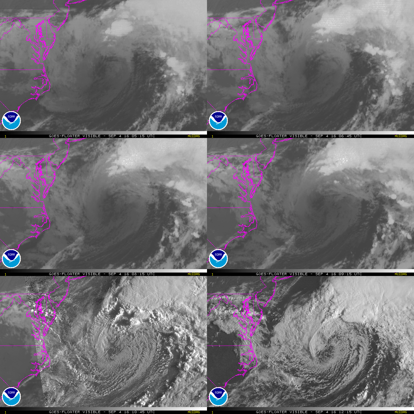
vis-animated

03. September 2016 · Comments Off on Hermine Saturday Update · Categories: Hurricane · Tags: ,

093741W_sm

New since the last post: Hermine is forecast to become a hurricane again once it re-enters the warm waters of the Atlantic. This may not occur until later Monday into Tuesday. The storm will be very slow moving and may not be out of the area until Thursday.

At this time, we may not get very much rainfall from this system in western New Jersey. We may only see 1/2″ of rain. Some computer models don’t give us any rain. Winds will be gusty – even inland.

The most impact from this storm will be along the shore. Winds there will be much stronger and there will be coastal flooding, especially at times of high tide. There will be MANY high tide cycles with this storm since it will be around for so long!

Tropical storm warnings now up for the Jersey shore.

Today, Saturday will be a relatively nice day but we will see an increase in clouds from Hermine. We shouldn’t start to feel the impact of the storm until later Sunday.

02. September 2016 · Comments Off on Hermine Forecast To Stall · Categories: Hurricane · Tags: ,

093741W_sm

Latest forecast map from the National Hurricane Center. The forecast continues to take Hermine well to the east of us. If this track verifies, we would receive very little impact and rain from this storm in western New Jersey. Along the Jersey shore is a completely different story. It is very RARE to have a storm like this stall for several days. If it does, even if weakening, the winds and seas will continue to pound the shoreline communities causing beach erosion and possibly coastal flooding.

Same watches and warnings are posted along the eastern seaboard.

As expected, Hermine did weaken down to a tropical storm overnight. This is not unusual as a tropical system moves over land. But once it emerges over the mid Atlantic waters, these waters are unusually warm from our hot summer. Warm waters is what feed and strengthen ocean storms….

Rainfall Forecast from Hermine

Rainfall Forecast from Hermine

As of right now it doesn’t look like we will receive much rain from Hermine in western New Jersey. There will be some rain as you head further east. This doesn’t mean we will have sunny skies either. I expect more clouds than sun while our friend is in town.

01. September 2016 · Comments Off on Hermine Now A Hurricane · Categories: Hurricane · Tags: , ,

093741W_sm

Hermine is now a hurricane which is what was expected to happen.

Tropical storm warnings are now up for the east coast of FL up to NC/VA border area. Tropical storm watch is issued north of that up to near NYC which includes the New Jersey shore.

Guidance today has continued the idea of the hurricane remaining east of us when it gets this far north. The storm continues to look like it will slow down when it does get here. Look how little it moves from 1 pm Sunday to 1 pm Tuesday (last three S with circle around them. Keep in mind it probably will not be as strong then as it is now.

If the storm stays on this track, western New Jersey will see less rainfall. The shore continues to look like it will get the most impact from this including beach erosion.

01. September 2016 · Comments Off on Tropical Storm Hermine Overnight Update · Categories: Hurricane, Summer · Tags: , , ,
NHC Hermine Overnight Update

NHC Hermine Overnight Update

the overnight computer models along with the National Hurricane Center have adjusted the forecast path for Hermine back to the East. This is not surprising and we will continue to see the forecast models sway back and forth. The storm isn’t even on land yet. Once it is we will have better data to make hopefully better forecasts.

The important thing to keep in mind is the trend. For the last day or two the trend was to have the storm come further north and east. Now we see on 12 hour period that shits it further to the east. Let’s see if this continue or not.

What’s important to note, if the above track verify’s, even though its not as close as the previous track it will impact our weather with some wind and rain on Labor Day weekend.

Another important item to note is the steering currents for this storm get very weak as it gets near our area. Notice how the last two forecast locations on the map above have the circles very close to each other. There is a possibility the storm could stall or become erratic. Again, we need to keep an eye on it and see if the trend continues.

In other news Stewartsville pickup up about 1/3″ of much needed rain overnight. Look for scattered showers this morning giving way to nicer weather and a beautiful Friday!

31. August 2016 · Comments Off on Tropical Storm Hermine Forms And Heading Our Way · Categories: Hurricane · Tags: ,
NHC Forecast Map for TS Hermine

NHC Forecast Map for TS Hermine

TD ( turning into TS Hermine today. The storm continues to move further north and west than originally thought. The revised NHC track has the storm approaching our neck of the woods just in time for a beautiful Labor Day weekend.

As of right now, if this continues on this track, windy rains could move into our area as soon as Saturday night.

I’ll continue to keep an eye on this and provide updates.

30. August 2016 · Comments Off on Tropical Update; Long Range Temperature Outlook · Categories: Fall, Summer · Tags: ,
East Coast Tropical Update

East Coast Tropical Update

Tropical depression 8 continue to look like it will move northeast and not impact our area.

Today will feature warm temperatures and low humidity. That changes on Wednesday as a strong cold front approaches the area on Wednesday. Tomorrow should be warm and humid. But then we get another brief taste of autumn with a few comfortable and cool days. Unfortunately we look to only receive about 1/4″ or rain as the cold front does not look to be too wet. This is unfortunate since it hasn’t rained since last Sunday and western New Jersey has returned to dry conditions.

8-14 Temperature Outlook

8-14 Temperature Outlook

After a nice comfortable start to the Labor Day weekend, above normal temperatures look to return into the first half of September. This trend looks to continue beyond this…

27. August 2016 · Comments Off on Tropical Update · Categories: Hurricane, Summer · Tags:
Tropical Update August 27, 2016

Tropical Update August 27, 2016

It’s that time of year again when we need to start paying attention to the tropics. Nothing major on the horizon. Area #1 in the map above, which was investigation area 99L, may re-energize as it heads into the Gulf of Mexico next week.

Another interesting area is #3 as that may impact the Carolina coast. None of these look significant at this point. But if you’re on a beach vacation in those areas, it’s significant!

16. August 2016 · Comments Off on More Storms Later? · Categories: Summer, thunderstorms · Tags: ,
Wide view of the radar shows additional showers in western PA that will move into western NJ overnight

Wide view of the radar shows additional showers in western PA that will move into western NJ overnight

First round of thunderstorms moved through western New Jersey this afternoon and early evening. The cold front is still to our west in western PA. As you can see in the radar above there are still some additional showers and thundershowers that will move though our area later tonight into the overnight. The big question is how strong will they be. With the sunset some of the energy will be taken away from these storms. But we all know how warm and humid the air is. This warm and humid air contains a lot of moisture and energy so if the right conditions come together there could be some heavier thundershowers.

The severe thunderstorm watch issued earlier is no longer in effect. I do not anticipate another watch being issued with the weather to our west.


16. August 2016 · Comments Off on Severe Thunderstorm Watch until 11 pm · Categories: Summer, thunderstorms · Tags:
Severe thunderstorm watch for western NJ

Severe thunderstorm watch for western NJ

The NWS Storm Prediction Center has issued a

* Severe Thunderstorm Watch for portions of 
  District of Columbia
  northern Delaware
  much of Maryland
  New Jersey
  eastern Pennsylvania
  northern Virginia
  coastal waters

* effective this Tuesday afternoon and evening from 320 PM until
  1100 PM EDT.

* Primary threats include...
  isolated damaging wind gusts to 70 mph possible
  isolated large hail events to 1.5 inches in diameter possible

Summary...north-south squall line is gradually intensifying over
central Pennsylvania into western Maryland.  Damaging winds can be
expected with this line of convection as it spreads toward New
Jersey.

The Severe Thunderstorm Watch area is approximately along and 70
statute miles east and west of a line from 25 miles south
southwest of Baltimore Maryland to 40 miles north of Allentown
Pennsylvania.  For a complete depiction of the watch see the
associated watch outline update (wous64 kwns wou7).

Precautionary/preparedness actions...

Remember...a Severe Thunderstorm Watch means conditions are
favorable for severe thunderstorms in and close to the watch
area. Persons in these areas should be on the lookout for
threatening weather conditions and listen for later statements
and possible warnings. Severe thunderstorms can and occasionally
do produce tornadoes.


Aviation...a few severe thunderstorms with hail surface and aloft
to 1.5 inches. Extreme turbulence and surface wind gusts to 60
knots. A few cumulonimbi with maximum tops to 500. Mean storm
motion vector 25030.
Floating Social Media Icons by Acurax Wordpress Designers
Visit Us On TwitterVisit Us On FacebookVisit Us On PinterestVisit Us On YoutubeVisit Us On Instagram