13. December 2016 · Comments Off on Calm Before The Cold · Categories: snow, weather discussion, winter · Tags: , ,
Light snow approaching from the SW

Light snow approaching from the SW

If you have any outdoor chores to do today is the day. There is some very light snow or flurries approaching from the SW. Look for them to arrive late afternoon into the early evening. It shouldn’t amount to too much but some areas may receive a dusting.

Wednesday will be a transition day as the next front will move through later in the day and into the evening ushering in the coldest air of the season. More details on that tomorrow…

12. December 2016 · Comments Off on The Week Ahead · Categories: snow, weather discussion, weather forecast, winter · Tags:
Snow Sunday falls on a Christmas Wreath For Sale

Snow Sunday falls on a Christmas Wreath For Sale

The storm from yesterday into this morning behaved pretty much as I expected. Stewartsville received about 2/10″ yesterday late afternoon and early evening and another 2/10″ overnight before changing to rain. I’ve seen reports of a few inches further to the north.

Roads were quite slippery late yesterday afternoon and early evening before crews could get to treat them.

Today will be the warmest day by far with high temperatures expected in the mid 40’s. So if you have anything outside to do, I recommend doing it today. There could be some snow showers late in the day or evening on Tuesday but the bulk of this should stay to our south.

Then the coldest air of the season arrives later Wednesday to make Thursday and Friday feel downright frigid. Temperatures those days will not not get out of the 20’s and overnight lows could fall into the single digits!

But don’t fret too much. It doesn’t look like this colder and colder pattern should continue. There are signs of a little moderation around the week before Christmas that could last until the new year. But that’s a way off so until then find your winter jacket!

11. December 2016 · Comments Off on Storm Analysis Tonight Into Monday Morning · Categories: precipitation, snow, weather discussion, weather forecast, winter · Tags:

Well it finally looks and feels like December! Here are some reasons this will NOT be a big snow producer for western New Jersey:

1. A warm front is approaching the area. This means once the front passes, we will get warm and the frozen precipitation will turn to rain eventually
2. The main storm system is going to go to our north and west, meaning we will be on the “warm” side of the storm
3. There is no cold high pressure to our north pumping in colder air

NWS expected snow fall

NWS expected snow fall

With the above in mind this is what will happen in western New Jersey. Periods of light snow will overspread the area this afternoon. This could start as early as mid day in some part of the area but most of that should stay to our west. We could see a coating on the ground from this.

Then there will be a break in the precipitation until the storm get closer to our area. The precipitation should resume mid to late evening and continue overnight.

I expect light snow to mix with sleet and freezing rain before eventually changing to plain rain by Monday morning. This transition will happen faster in southern and lower elevation areas. Areas further north and more elevated areas will see the transition take longer.

In southern warren county, central and southern hunterdon counties I expect a coating to 1″ of snow before changing over to mix then rain. North of that area up to and perhaps just a little bit further north of I-80 I can see 1-3″ of light snow. North of that has the potential for 3-6″ before the changeover.

There could be some light ice buildup during the changeover period so be aware of that.

The Monday morning commute will need some extra travel time so please allow for it.

The National Weather Service has issued a Winter Weather advisory starting at 1 pm today lasting into tomorrow.

08. December 2016 · Comments Off on Coldest Air of the Season (so far) On the Way · Categories: winter · Tags:

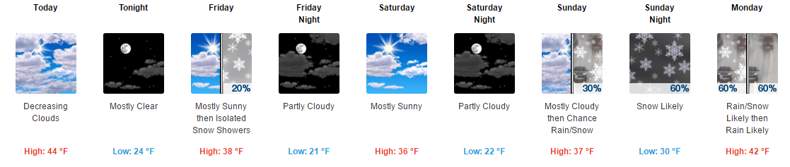
An arctic cold front will cross western New Jersey later today and usher in the coldest air of the new cold season so far. High temperatures will not get out of the 30’s Friday through the weekend. It will be blustery with low wind chill readings. There’s even the possibility of a snow shower or two here and there.

The our attention turns to later in the day Sunday into Monday morning. A low pressure system will be arriving from the northwest. Depending on where it does we could have some wintry weather Sunday night into Monday morning. More details as we get closer.

Stay warm and make sure the holiday decorations are secured as we could get some wind gusts in the 30’s.

05. December 2016 · Comments Off on More Rain and Snow For Tuesday · Categories: Fall, snow, winter · Tags: , , ,

stormtotalsnowweb

Look for sun to give way to increasing clouds on Tuesday in western New Jersey. Precipitation should arrive before the evening rush hour. I expect this system to be primarily a rain event along the I-78 corridor. Further to the north, there will be colder air and there could be some sleet and wet snow mixed in at the beginning of the storm.

The above snow forecast map from the Nation Weather Service, only has measurable snow around and north of I-80.

We need to keep an eye on how much cold air get drawn into this system. There are some computer models that are suggesting more wintry weather may happen for a little while further to the south, especially in the beginning. I’ll keep an eye on this tomorrow and will post updates as appropriate.

05. December 2016 · Comments Off on First Snow of December · Categories: Fall, snow · Tags: , , ,

20161205_074057

The first snow of December is in the books. This is our second snowfall of the fall. 1/2″ was recorded in Stewartsville, NJ. I’ve seen reports of as much as 1.5″ in High Point NJ.

Take a picture if you like snow on the ground becasue it won’t last long. Rain returns later Tuesday into Wednesday morning. Then colder air arrives later in the week.

04. December 2016 · Comments Off on Light Snow Potential Monday Morning · Categories: snow · Tags: , , ,

stormtotalsnowweb1

A relatively weak system will be moving into the western New Jersey area later Sunday evening into the overnight hours and Monday morning. Initially temperatures may be warm enough to produce some cold rain showers. As the precipitation picks up a little and the atmosphere cools down, we should see this change over to light wet snow.

How much? Right now it looks like a coating to 1″ in most of the area. Further to the north and in elevated areas (> 1000′) you may see 1-2″ of snow.

namsnow-2-900x400

Certainly not a crippling event BUT it will be the first event of the season and Monday morning commutes are stressful enough as it is.

But it is December and will be seeing more of this potential in the weeks ahead. The rest of the mid week will feature on and off light chances of rain. Then the coldest air of the season arrives late Thursday into next weekend. The weather pattern looks to turn active! Who’s happy about that?

30. November 2016 · Comments Off on Much Needed Rain Received; More On The Way · Categories: Fall, precipitation · Tags: , ,
Much needed rain received in past 24 hours and forecast for more

Much needed rain received in past 24 hours and forecast for more

Stewartsville received just over 1.5″ of rain in the past 24 hours with more on the way! The top left graphic shows how much rain fell in the past 24 hours. The lower left shows the forecast for today into tonight. In general it looks like western New Jersey will receive 1/2 – 1″ of additional rain.

Rainfall received in the area in the past 24 hours

Rainfall received in the area in the past 24 hours

24. October 2016 · Comments Off on Freeze Watch For Wednesday Morning · Categories: Fall · Tags:
Last October in western New Jersey. Photo by Dave Dabour

Last October in western New Jersey. Photo by Dave Dabour

Well this week it will finally feel like late October. It’s been looking like late October, just not feeling like it.

We have a freeze watch in effect for late Tuesday night and early Wednesday morning. If there’s anything growing outside that you care about, last call.

...Freeze watch in effect from late Tuesday night through
Wednesday morning...

The National Weather Service in Mount Holly has issued a freeze
watch...which is in effect from late Tuesday night through Wednesday
morning.

* Locations...much of eastern Pennsylvania, portions of New Jersey
  into parts of both northeast Maryland and far northern Delaware.
  This freeze watch does not include the urban centers near
  Philadelphia.

* Temperatures...lows are expected to range within several degrees
  of 30 early Wednesday morning over the Countryside. Frost or
  freezing temperatures are forecast within the watch area. 

* Timing...coldest temperatures should occur between 6 am and 730
  am Wednesday, with frost or freezing temperatures possibly
  beginning as early as midnight in the normally colder sheltered
  valleys. 

* Impacts...the upcoming seasonably cold frost or freeze event
  will probably end the growing season in parts of this area,
  especially near and north of Interstate 78 inclusive of the
  Lehigh Valley. If and when warnings or advisories are issued,
  protective action should be considered for sensitive outdoor
  plants.

Precautionary/preparedness actions...

A freeze watch means sub-freezing temperatures are possible.
These conditions could kill crops and other sensitive vegetation.
19. October 2016 · Comments Off on How Long Will July In October Last? · Categories: Fall · Tags:

20161016_081004

I hope everyone that enjoys warmer weather is taking advantage of this crazy July in October weather. To put this in perspective, our overnight lows are what our daytime highs should be!!

7day

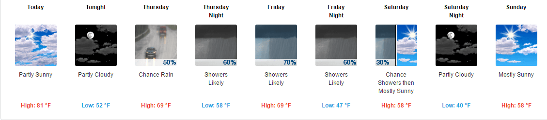
We should be able to turn off the A/C tonight as overnight lows will fall into the still above normal lower 50’s. By this weekend the warm temperatures will only be a distant memory as we struggle to get out of the 50’s for daytime highs!

Floating Social Media Icons by Acurax Wordpress Designers
Visit Us On TwitterVisit Us On FacebookVisit Us On PinterestVisit Us On YoutubeVisit Us On Instagram