
Event cancelled. Areal Flood Advisory from 8/13/2018 11:22 AM to 2:45 PM EDT for Northampton County. More information at inws.ncep.noaa.gov/a/a.php?i=24945249
New event. Areal Flood Warning from 8/13/2018 11:21 AM to 3:15 PM EDT for Northampton County. More information at inws.ncep.noaa.gov/a/a.php?i=24945178
New event. Areal Flood Advisory from 8/13/2018 10:40 AM to 2:45 PM EDT for Northampton County. More information at inws.ncep.noaa.gov/a/a.php?i=24944160

Flash Flood Watch
Most sections of western New Jersey saw and heard a good amount of rain and thunderstorms in the wee hours of this morning. Stewartsville received 1.04″ of new rain as of 7:30 am today. More rain has fallen since then. All of this rain has resulted in a Flash Flood Watch for the entire area.
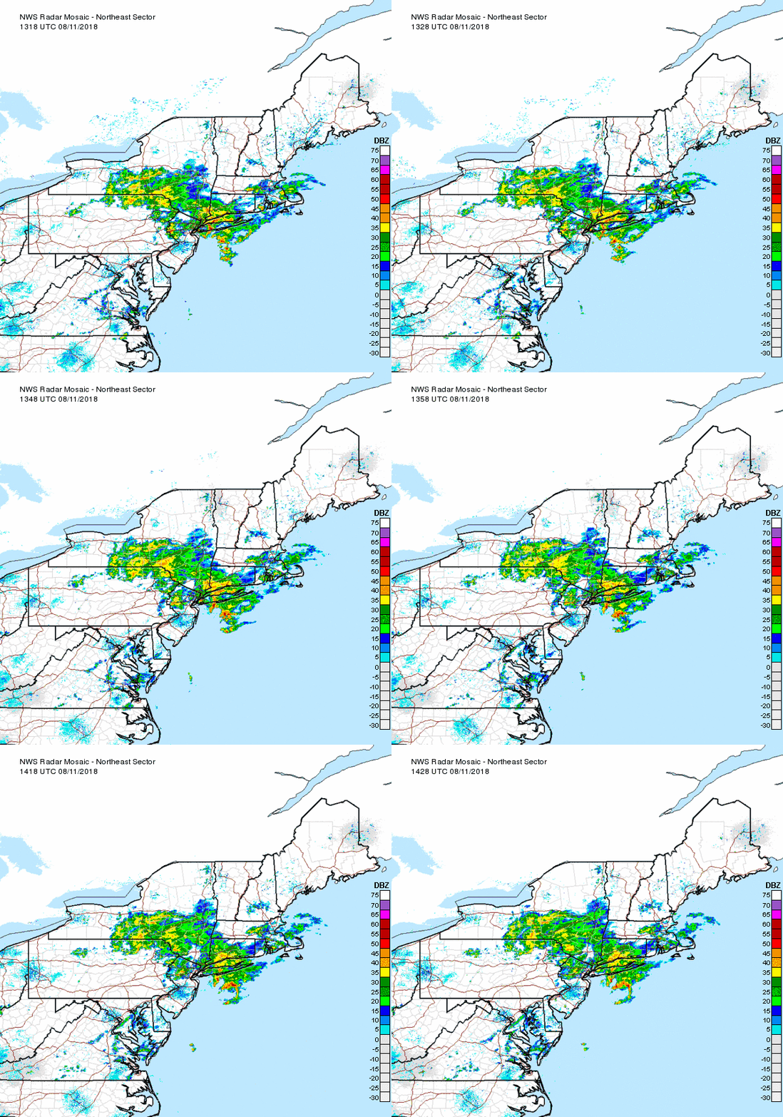
NE Radar Loop
As of mid-day the good news is most of the heavier rain has moved thru extreme western New Jersey and will be out of all of northern NJ soon. As you can see in the radar loop above there appears to be a break in the precipitation. How long will it last? I suspect we will see rain returning by mid to late afternoon.

Weather Outlook this weekend
Our overall forecast from 8 am this morning until Sunday morning is more heavy rains possible with flash flooding possible.

1-2 Day Precip Total forecast
The above map shows extreme western New Jersey forecast to receive about another 1.50″ of rain from Saturday morning until Monday morning. Sections further to the east could be closer to 2″

SPC shows marginal risk of severe weather today
The Storm Prediction Center has our entire area in a marginal risk for severe weather later today and tonight. A weak cold front will be approaching and moving through the area later today and tonight. This will produce some scattered thunderstorms later today and tonight. At this time they don’t look to be very strong or in a squall line. Instead they look scattered. But keep in mind any thunderstorm can turn strong and deadly quickly. The old adage “when thunder roars, head indoors” is good advice.
We did have another heat wave as of yesterday. Tuesday was our third day in a row of high temperatures hitting 90 or better. Today will be close but we may stay just shy of the 90 degree mark. Even if the temperature doesn’t hit 90 the humidity will certainly make it feel that warm if not warmer.

5 Day NWS forecast
After today we should only see high temperatures in the 80’s for at least the next 5 days. Looking longer range temperatures should increase again somewhat later next week perhaps.

Thunderstorm damage on Warren Glenn Rd evening of August 7, 2018. Photo by DAVE DABOUR
As small but strong gusty thunderstorm moved across southern areas of western New Jersey last evening. Stewartsville picked up almost 2/3″ of rain and a wind gust to 38 mph.

Thunderstorm damage on Warren Glenn Rd evenining of August 7, 2018. Photo by DAVE DABOUR
There were numerous small branches and leaves down in the area. Not too far away was a transformer fire on a utility pole due to the storm.
I didn’t get to experience the storm in person as I was just north of the storm photographing a family. We heard the thunder and got to see some impressive cloud formations! There was even a nice rainbow after the storm that was a complete arc across the sky.

Heat Advisory Issued Today
339 AM EDT Mon Aug 6 2018

...HEAT ADVISORY REMAINS IN EFFECT FROM NOON TODAY TO 7 PM EDT
THIS EVENING...

* HEAT INDEX VALUES...Between 100 and 104 due to temperatures in
  the low to mid 90s, and dewpoints in the lower 70s.

* TIMING...The highest heat index values will occur during the
  afternoon into the early evening.

* IMPACTS...The heat and humidity may cause heat stress during
  outdoor exertion or extended exposure.

PRECAUTIONARY/PREPAREDNESS ACTIONS...

A Heat Advisory means that a period of hot temperatures is
expected. The combination of hot temperatures and high humidity
will combine to create a situation in which heat illnesses are
possible. Drink plenty of fluids...stay in an air-conditioned
room...stay out of the sun...and check up on relatives and
neighbors.

Take extra precautions...if you work or spend time outside. When
possible...reschedule strenuous activities to early morning or
evening. Know the signs and symptoms of heat exhaustion and heat
stroke. Wear light weight and loose fitting clothing when
possible and drink plenty of water.

To reduce risk during outdoor work...the occupational safety and
health administration recommends scheduling frequent rest breaks
in shaded or air conditioned environments. Anyone overcome by
heat should be moved to a cool and shaded location. Heat stroke
is an emergency...call 9 1 1.
The National Weather Service in Mount Holly NJ has extended the
* Flood Warning for…
Sussex County in northwestern New Jersey…
Warren County in northwestern New Jersey…
* Until 400 PM EDT.

Flood Warning until 4 pm Saturday
No arguing a lot of rain in the last 24 hours! 2.85″ in Stewartsville from 7 am Friday until same time Saturday morning. More rain in other areas. Smaller rivers near/at flood levels.

Threat for severe weather later today
There continues to be a slight risk of severe weather later today. It will not be an all day rain but rather spotty here and there. If the weather looks threatening, head indoors!

SPC severe weather outlook for Wednesday
I’ve mentioned in previous posts that we will be seeing more humidity and rain this week. So far it has held off. There were some sprinkles yesterday with some heavier rain in isolated sports to out south.
Wednesday looks to increase the chances of more rain and humidity. In the map above, the SPC has place EPA and extreme western New Jersey in a slight risk for severe weather. Some of the computer models are suggesting a line of thunderstorms tomorrow evening around 9 pm or so. We’ll keep an eye on these storms tomorrow.

Excessive rain outlook for Wednesday
As seen in the above map, there is a slight chance of rainfall reaching flash flood guidance Wednesday in central PA – exactly the place that doesn’t need more rain!

Excessive rain outlook for Thursday
Unfortunately it doesn’t get any better on Thursday. As seen in the map above that area shifts closer and even touches western New Jersey

1-5 day rain total

1-3 day rain total
As seen in the above maps, we have the potential to receive 1 to perhaps 3″ of rain in the next several days. We can thank the moist pattern we are once again in bringing humid air from the tropics right into out own backyeards


Recent Comments