
New event. Winter Weather Advisory from 11/15/2018 10:00 AM to 11/16/2018 7:00 AM EST for Warren County, Northampton County. More information.
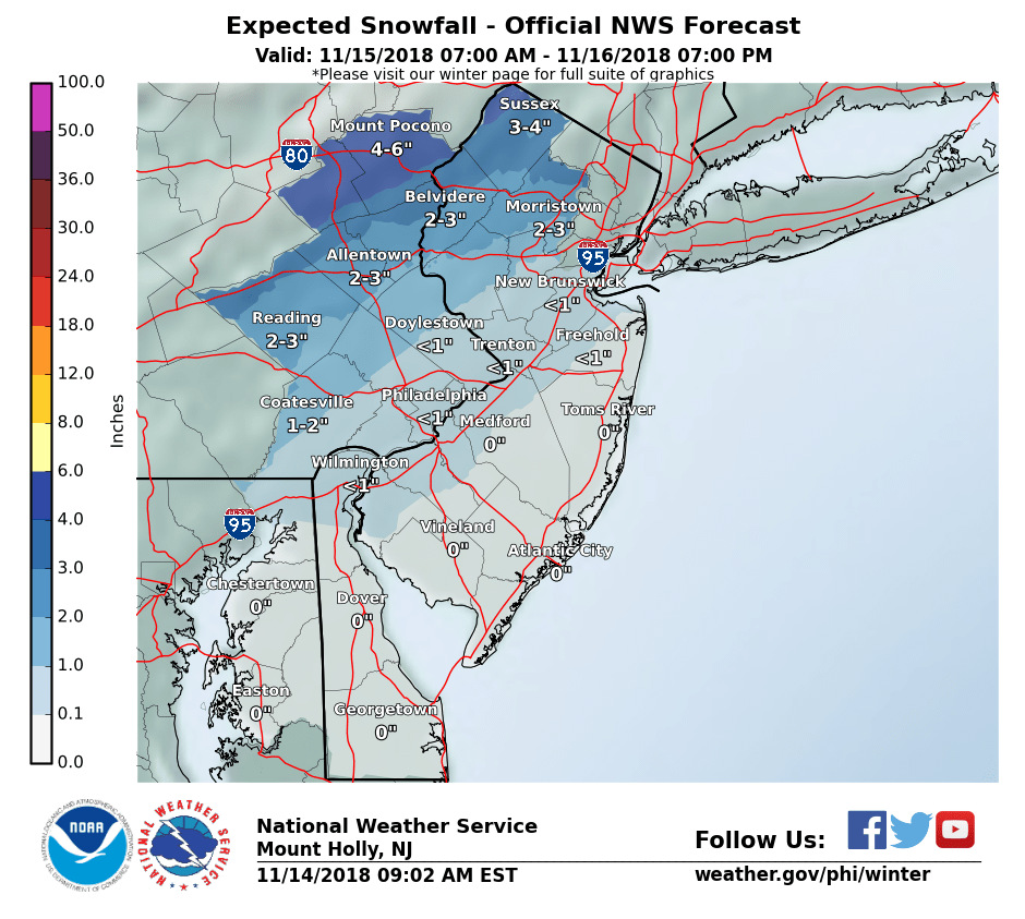
NWS snow forecast for Thursday
Many computer models and other sources of information used to make weather forecasts have trended colder for tomorrow’s storm. The high pressure system to the north that will develop today will be stronger than originally thought. As a result today we will not see temperatures go up that much from where there are now despite sunshine. Tonight will be the coldest night of the new cold season.
As a result I’m increasing my snow forecast for tomorrow to a coating to 2″ with more to the north. The snow will still mix with and change to sleet/freezing rain and then rain my Thursday evening. The devil is in the details as they say as to when this happens. Most of the time for for I-78 corridor this happens sooner than anticipated. I’m counting on that to happen again this time hence why my snow totals are lower than the NWS map above. But of course the potential is there to receive more.

Thursday forecast
Colder air is arriving today to dry out the overnight rain. Winds will pick up and be clustery at times. We should see more tomorrow on Wednesday. There’s even a good chance we could see some snow flurries on Wednesday or even possibly a snow squall as some colder air arrives.
The we turn our attention to Thursday. A coastal storm will be approaching our area. We will start off cold but warmer air will slowly make it way into our area. We should start off as some wet snow that will mix with sleet and then eventually changeover to a cold rain. When the precipitation arrives will help determine how much, if any accumulation we receive.

NWS 5 day forecast
There’s a of of thing we need to keep in mind in determining if we will receive any accumulation of snow on Thursday:
- This is the first event of the season. Yes its been cold out recently but not very cold. The ground is warm
- Most of the precipitation on Thursday will be falling during the day. To get snow to accumulate during the day, especially in early and late season, you need it to snow very hard
- As the heavier precipitation approaches later in the day, so will the warmer air that will eventually change us over to rain.
My initial thoughts are we will see a wintry mix during the day on Thursday. I think the roads will be fine. There may be some whitening on untreated surfaces. On those surfaces we could see a coating to perhaps 1″. More accumulate further to the north and west (up near I-80)
I’ll provide updates as they become available.
Event cancelled. Areal Flood Watch from 11/9/2018 8:21 PM to 11/10/2018 6:00 AM EST for Hunterdon County, Warren County. More information.
New event. Areal Flood Advisory from 11/9/2018 4:42 PM to 8:45 PM EST for Hunterdon County. More information.
New event. Areal Flood Watch from 11/9/2018 6:00 PM to 11/10/2018 6:00 AM EST for Hunterdon County, Warren County. More information.
SPSPHI from 11/6/2018 7:02 PM to 10:15 PM EST for Northampton County. More information.

SPC severe weather risk for Tuesday
The threat for severe weather today has shifted further to the south. This is in part mostly due to the arrival of the precipitation around midday to early afternoon. There will not be much heating of the atmosphere since we’re starting off cloudy and drizzly in spots.

Radar as of 8:30 am
The last thing we need in western New Jersey is anymore rain. It’s knocking on the doorstep of our area. Look for the worse of it around mid day to early-mid afternoon. If you haven’t voted yet I recommend doing it ASAP or later on today or tonight.

Rain total forecast
Thankfully yesterday’s rainfall forecast came up short (for a change). Stewartsville only received 0.22″ of new rain. Today we could see p to 1/2″ of additional rain. Some of it may come down quickly as a line of heavier shower and possibly a thundershower is forecast to approach from 11- 3pm
SPSPHI from 11/6/2018 5:46 AM to 9:00 AM EST for Hunterdon County, Warren County, Northampton County: Areas of fog this morning. More information.

24 hour precipitation forecast
Another rainy day is in store for western New Jersey Monday. Expect about 3/4″ of new rain ending tomorrow morning.

Severe weather risk for Tuesday
Come tomorrow the rain won’t go away. In fact as a cold front approaches, we could have a repeat of severe weather for NOvember. The Storm Prediction Center has placed all of western New Jersey in a marginal risk for severe weather. Further to the SW you can see the yellow in the map above for an increased or slight risk of severe weather. We’ll keep an eye on this and keep you posted as best we can.

7 Day NWS forecast


Recent Comments