27. September 2018 · Comments Off on Flood Watch Tonight into Friday Morning · Categories: Fall, flood watch · Tags:

Flood Watch

Boy when it rains it pours around here. Stewartsville only received 0.06″ of rain yesterday at my station but I was attending a meeting on the other end of town and I could hear the rain pounding down on the roof. Not sure how much fell there but LVI airport was under the same cell and received 0.65″ of rain.

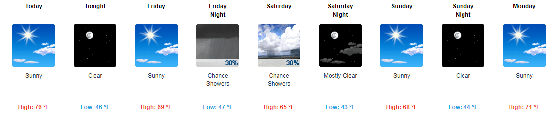
A wave of low pressure has formed on the cold front that pushed through last night as was responsible for all the rain. Look for a chance of shower later today and this evening. The steadiest and heaviest rain will be overnight into Friday morning. We are only expecting about 1/2″ of new rain but with the ground being so saturated it won’t take much to cause problems in some areas hence the Flood Watch.

Friday afternoon the weather will greatly improve. We should be OK for Friday NIght Lights and a b-e-a-utiful Fall weekend!

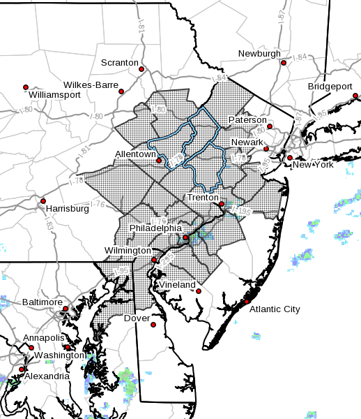
…FLOOD WATCH IN EFFECT FROM THIS EVENING THROUGH LATE TONIGHT…

The National Weather Service in Mount Holly has issued a

* Flood Watch for portions of eastern Pennsylvania, portions of northern, central and southwestern New Jersey, northern Delaware, and northeastern Maryland.

* From this evening through late tonight.

* An area of heavy rain is forecast to lift northeastward across the region tonight. Rainfall totals up to an inch or two are expected with some locally higher amounts possible.

* The heaviest of the rain is expected to fall over only a few hours. As a result, localized flooding is anticipated on roadways and in areas of poor drainage. Small streams and creeks are already running high and some minor flooding may occur.

PRECAUTIONARY/PREPAREDNESS ACTIONS…

A Flood Watch means there is the potential for flooding based on the current forecast.

If you live in a location that is prone to flooding, please monitor the forecast through the day and be alert for possible Flood Warnings tonight.

26. September 2018 · Comments Off on Severe Weather Threat Later Today · Categories: Fall, thunderstorms, weather discussion · Tags: ,

SPC severe weather threat for today

The Storm Prediction Center has placed all of western New Jersey in a slight risk of severe weather today. The best chances for this will be late afternoon into the evening. This area has shifted slightly to the west over the past 24 hours. These storms will be the result of the unseasonably warm and humid weather we will see in the area today. Some areas could see 80 degrees and humidity will get to levels seldom seen in September.

Rain totals Tuesday

Yesterday’s forecast lived up to its potential and gave our area another good rainfall. Stewartsville received 1.41″ just since 7am Tuesday alone. This combined with what fell overnight Monday gave us 1.62″ of not needed rain. The above map shows more totals in northern NJ. Map courtesy of Rutgers NJWxNet.

Right now it looks like a nice fall weekend!

24. September 2018 · Comments Off on Brief Return To Summer with Rain and Thunder · Categories: Fall, thunderstorms · Tags: ,

Total rain forecast thru Wednesday

Our taste of fall and some dry weather takes a break on Tuesday and especially Wednesday. A soaking rain is on the way overnight into early Tuesday morning. MOst areas of western New Jersey look to receive 1-1.50″ of rain. The steadiest rain should be later Monday night into Tuesday morning. Then the rain should become more showery and intermittent.

SPC Wednesday Outlook

Then much warmer and unstable air move in on Wednesday before a cold front move thru later at night and brinks back the cooler temperatures. The SPC has placed our entire area in a slight risk of severe weather Wednesday. Right now the afternoon and evening looks to be the time frame.

26. October 2017 · Comments Off on Rain still on track for Sunday · Categories: Fall · Tags: , ,
Rain forecast for Sunday into Monday

Rain forecast for Sunday into Monday

Rain is still forecast for Sunday into Monday but amounts for western jersey are reduced per the above graphic. But 2″ would still be a much beneficial rainfall. I just hope the trend doesn’t continue and the heavier rain gets pushed to the east…

25. October 2017 · Comments Off on Closer to normal temperatures; Rain on Sunday · Categories: Fall · Tags: ,
Rainfall forecast for Sunday into Monday

Rainfall forecast for Sunday into Monday

The rainfall yesterday was on the lighter side of what was forecast. But some rain is better than no rain. Stewartsville received 0.66″ of rain.

Today will feature high temperatures in the 60’s which is above the seasonable normal of 61. Tomorrow will be slightly below normal with a high of 59. Then we moderate late week into the weekend. Saturday looks very nice but rain is forecast to move into the area on Sunday and it could be a good soaking as shown in the map above.

23. October 2017 · Comments Off on Potentially severe weather ushers in back to normal · Categories: Fall, precipitation, thunderstorms · Tags:
Severe weather threat for Tuesday

Severe weather threat for Tuesday

All good things must come to an end. The string of above normal temperatures for western jersey for late October will come to an end starting tomorrow. That change might arrive with some potentially severe weather. Right now the best time looks like late morning to mid day. This could extend later on to the east.

As you most of you know we are also very dry. We look to receive 3/4″-1″ of rain from this system.

The we return to normal and maybe a little below normal on Thursday as cooler weather returns to western new jersey. Out normal high temperature this time of year is 62 degrees.


28. September 2017 · Comments Off on Fall Arrives….. One week Late · Categories: Fall · Tags: , ,
7 Day forecast for western New Jersey

7 Day forecast for western New Jersey

The early fall heat wave is over! Much more seasonable and enjoyable weather is finally here. Or back if you remember the early part of the month! Some warmer and above normal weather looks to return around the middle of next week but ti doesn’t look to be as warm as what we just had – hopefully only mid 70’s for daytime highs.

8-14 day precipitation forecast

8-14 day precipitation forecast

8-14 day temperature forecast

8-14 day temperature forecast

In looking ahead to the first half of October for western Jersey, warm and dry trend of late looks to continue. My lawn is starting to show signs of dryness – first time this warm season!

HOpefully we will still have cool nights. Fall foliage likes warm days and cool nights to bring out the best and brightest colors!

22. September 2017 · Comments Off on Autumnal Equinox · Categories: Fall · Tags: , ,

Happy first day of fall 2017! While it may not feel like fall like outside it officially begins shortly after 4 pm today.

6-10 day temperature outlook

6-10 day temperature outlook

Warmer temperatures will continue well into most of next week as well. In fact we will unfortunately flirt with the 90 degree mark Sunday and Monday!

Fall foliage report

Fall foliage report

So now that it’s fall we need to start thinking about the beautiful colors of fall. There is some colors out there already.

Post tropical storm Jose is still out there but slowly weakening and should diminish without causing any issues. Hurricane Maria should stay off-shore the eastern US after devastating Puerto Rico and other nearby islands.

Cooler weather should hopefully return by October.

15. September 2017 · Comments Off on No Way Jose! · Categories: Fall, Hurricane · Tags:

NHC Jose Forecast

Even though Jose is downgraded to a tropical storm, a little bit of strengthening is forecast to bring it back to a cat 1 hurricane in the days ahead. As you can see in the map above, the National Hurricane Center is forecasting it to ride up the east coast next week with the greatest threat to Cap Cod and New England.

What’s important here is the trend. The computer models have been trending further and further to the west with most of their runs. If this continues it could have more impact to the east coast.

At this point it doesn’t look like it will strengthen to a major hurricane but could cause issues none the less with beach erosion and flooding of low lying places. The american model had the storm much closer to coast!

05. December 2016 · Comments Off on More Rain and Snow For Tuesday · Categories: Fall, snow, winter · Tags: , , ,

stormtotalsnowweb

Look for sun to give way to increasing clouds on Tuesday in western New Jersey. Precipitation should arrive before the evening rush hour. I expect this system to be primarily a rain event along the I-78 corridor. Further to the north, there will be colder air and there could be some sleet and wet snow mixed in at the beginning of the storm.

The above snow forecast map from the Nation Weather Service, only has measurable snow around and north of I-80.

We need to keep an eye on how much cold air get drawn into this system. There are some computer models that are suggesting more wintry weather may happen for a little while further to the south, especially in the beginning. I’ll keep an eye on this tomorrow and will post updates as appropriate.

Social Media Integration by Acurax Wordpress Developers
Visit Us On TwitterVisit Us On FacebookVisit Us On PinterestVisit Us On YoutubeVisit Us On Instagram